Sold2022[PACIFIC NORTHWEST]. Two pictorial maps of Oregon and Washi...[PACIFIC NORTHWEST]. Two pictorial maps of Oregon and Washington. Including: -- PETRUCCELLI, Antonio (1907-1994). Pictorial map of Washington and Oregon. 1940. Art Deco style map of the Pacific NorthwSee Sold Price
Sold2023[AVIATION]. Two pictorial maps. Includes: CHEESEMAN, F.E. A...[AVIATION]. Two pictorial maps. Includes: CHEESEMAN, F.E. Aviation Panorama. 1943. Milwaukee: Albert Richard Company. Colorful pictorial map in “Tribute to the Pioneer Spirit, the Inventive GeniSee Sold Price
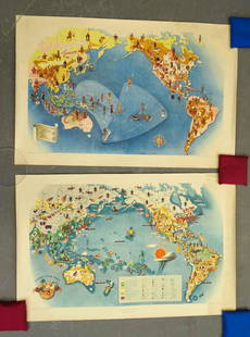
Sold2023CHASE, Ernest Dudley (1878-1966). Two pictorial maps of Ame...CHASE, Ernest Dudley (1878-1966). Two pictorial maps of America. Includes: America the Wonderland / A Pictorial Map of the United States. 1954. Philadelphia: The Inquirer Colorama. Color pictorial mapSee Sold Price
Sold2023[PICTORIAL MAPS]. Two maps. Includes: JANNOT, J.B. (“Jan Lo...[PICTORIAL MAPS]. Two maps. Includes: JANNOT, J.B. (“Jan Loup”). Grand Circuit Des Capitales. France: Agence Francaise de Propagande. Promotional map of Europe and Asia for Menier chocolatSee Sold Price
Sold2022Fun Map of New Zealand. Wellington, ca. 1940. Pictorial map...Fun Map of New Zealand. Wellington, ca. 1940. Pictorial map of New Zealand, designed by the Charles Haines Advertising Agency of Wellington, and published by the New Zealand Government Tourist DepartmSee Sold Price
Sold2021Covarrubias Pacific Asia Pictorial Maps (2)Maps of the Pacific, Golden Gate International Exposition. NY, 1942. Miguel Covarrubias (1904-1957). 2 Maps: Peoples and Economy. Australia, Hawaii, Asia, Americas. .See Sold Price
Sold20191940 Cheeseman Pictorial Map of the US Relating toTitle/Content of Map: 1940 Cheeseman Pictorial Map of the US Relating to College Football -- Albert Richard Football Map Date: 1940 MilwaukeeCartographer: F Cheeseman Size: 19 x 26 in. This is a verySee Sold Price
Sold20181944 Western Pacific Railroad Pictorial Map of WesternTitle/Content of Map: 1944 Western Pacific Railroad Pictorial Map of Western US with Illustrations -- From San Francisco along the line of Western Pacific Railroad to Salt Lake City Date: 1944, DenverSee Sold Price
Sold2021[NATIONAL PARKS] LINDGREN, Jolly. Hysterical Map of[NATIONAL PARKS] LINDGREN, Jolly. Hysterical Map of Bryce Canyon National Park. Spokane, WA, 1940. Comical pictorial map of the national park in Utah, with all sorts of amusing jokes and puns about thSee Sold Price
Sold2023ASSORTED EUROPEAN / AFRICAN PICTORIAL MAPS, LOT OF TWOASSORTED EUROPEAN / AFRICAN PICTORIAL MAPS, LOT OF TWO, engraving on paper, comprising a bird's-eye view of the siege of the town Oost Ende (Ostend), a Flemish town, during The Eighty Years' WSee Sold Price
Sold2018Pictorial Map of the American Continent, 1940Title/Content of Map: Pictorial Map of the American Continent Date Printed: c1940 Cartographer: GENERAL DRAFTING CO. Size: 23.6X17.25 Interesting map showing principal products of each country in theSee Sold Price
Sold2018Northern Pacific RR Yellowstone Booklet Map, 1940Title/Content of Map: 1940 Northern Pacific RR Yellowstone Booklet -- Astonishing Yellowstone; Northern Pacific Railroad Promotional Brouchure Date Printed: 1,940 Cartographer: Northern Pacific RailroSee Sold Price
Sold2021(PICTORIAL MAPS.) Miguel Covarrubias. Pageant of the(PICTORIAL MAPS.) Miguel Covarrubias. Pageant of the Pacific. Set of 6 large offset color lithographed maps. 25x38 and 19x25 inches each sheet size; without portfolio or descriptive pamphlet; soft verSee Sold Price
Sold2021San Diego with pictorial recreation map 1935Heading: (California - San Diego) Author: Title: Map of San Diego California City and County - with two maps, one a pictorial bird's-eye map Place Published: [San Diego] Publisher:Lowell E. Jones <See Sold Price
Sold2018Fire Fountains and Other Volumes on Hawaii.[Hawaii] Fire Fountains and Other Volumes on Hawaii. Including Fire Fountains (Edinburgh, 1883) by Cumming, two vols. original pictorial cloth, frontispieces, two maps, plates, mild lean; The HawaiianSee Sold Price
Sold2022DESIGNER UNKNOWN. SUN VALLEY IDAHO / UNION PACIFICDESIGNER UNKNOWN SUN VALLEY IDAHO / UNION PACIFIC RAILROAD. Two posters. Circa 1940. 26x36 inches, 66x91½ cm. Condition varies, generally B+: darkening, time-staining and creases in margins; smalSee Sold Price
Sold2022(PICTORIAL MAPS.) D.E. Bates. Cunard R.M.S. Caronia / Great African Cruise 1950.(PICTORIAL MAPS.) D.E. Bates. Cunard R.M.S. Caronia / Great African Cruise 1950. Color offset-printed pictorial map advertising the Caronia's route on a two-and-a-half-month's-long affair: departing NSee Sold Price
Sold2022(PICTORIAL MAPS -- INTOXICATION INFATUATION.) H.J. (Heinie) Lawrence. Map Showing Isle of Pleasure,(PICTORIAL MAPS -- INTOXICATION INFATUATION.) H.J. (Heinie) Lawrence. Map Showing Isle of Pleasure, Scale Two Fingers to the Drink. Offset color-printed map of an alcohol-obsessed land loaded with allSee Sold Price
Sold2021Ruth Taylor White Hawaii Pictorial Maps (4)Island of Hawaii. Maui. Oahu. Kauai. Set of 4 Cartographs. Printed by The Paradise of the Pacific for the Hawaii Tourist Bureau, Honolulu. C. 1935. Ex library..See Sold Price
Sold2019Two Maps by the Hydrographic Office U. S. Navy,Two Maps by the Hydrographic Office U. S. Navy, consisting of "South Pacific Ocean, Anchorages in the Fiji Islands, 1925, H. - 23 3/8 in., W. - 33 1/2 in.; together with "South Pacific Ocean, Plans inSee Sold Price
Sold2022PAIGE, Paul. A Map of Cape Cod. East Brewster, MA, ca. 1940...PAIGE, Paul. A Map of Cape Cod. East Brewster, MA, ca. 1940s. Pictorial map showing towns, forests, bridges, lighthouses, and landmarks, marking vacation and tourist attractions, including a key to goSee Sold Price
Sold2023Michigan / Upper Peninsula. 1940. [Published by the State o...Michigan / Upper Peninsula. 1940. [Published by the State of Michigan]. Pictorial map of Michigan, by an anonymous Regionalist artist, with an inset letter from Governor Luren D. Dickinson, in part, &See Sold Price
Sold2020Trails of Early Idaho by Anderson 1940Trails of Early Idaho - The Pioneer Life of George W. Goodhart by Abraham C. Anderson. Caxton Printers, Caldwell, Idaho. 1940 with dust jacket unclipped. Illustrated. Pictorial map on endsheets. CreamSee Sold Price
Jun 13Swann Auction Galleries(PICTORIAL MAPS.) Two early twentieth-century pictorial maps of Santa Barbara, California.$450
Jun 13Swann Auction Galleries(PICTORIAL MAPS.) John Held, Jr. Motor Routes to "Real New England Inns".$600
Jun 27Rail & Road Auctions52 Pieces of Union Pacific Railroad Ephemera - Pocket Calendars, Maps, Aluminum Coins, etc$30
BonhamsJoseph Davey Cunningham, A History of the Sikhs, from the Origin of the Nation to the Battles of...£1,200
BonhamsHARLEQUINADE - MANUSCRIPT FLAP-BOOK A seventeenth century manuscript pictorial flap-book 'Painte...£1,800
Jun 27Rail & Road AuctionsUnion Pacific Railroad Silver Salt & Pepper Shaker Set and Desert Flower China Bowls$50
Jun 13Swann Auction Galleries(ART DECO.) Two early twentieth-century French albums of pochoir plates.$1,500
Jun 13Swann Auction Galleries(PHOTOGRAPHY -- STEREOVIEWS.) Carleton Watkins, J.J. Reilly, and others. Group of approximately 80$750
Jun 13Swann Auction Galleries(MIDDLE EAST.) David Roberts. The Holy Land, Syria, Idumea, Arabia, Egypt & Nubia.$1,500
BonhamsPOTTER (BEATRIX) The Tale of Timmy Tiptoes, 1911; The Tale of Pigling Bland, 1913, FIRST EDITION...£300
3 days LeftLeon GalleryVincenzo Maria Coronelli (1650-1718) - Asia Divisa Nelle sue Parti Secondo lo Stato Presente₱220,000
Jun 28Rail & Road AuctionsGroup of Fourteen Railroad Stock Certificates - Illinois Central, Denver & Rio Grande Western,$30
BonhamsTWO PICTORIAL PINCHBECK PAPERWEIGHTS, England, mid-19th century, both on turned wood base, an or...$100
Jun 13Swann Auction Galleries(PICTORIAL MAPS.) Arthur Kelly David Healy. Dartmouth College Campus.$375


![[PACIFIC NORTHWEST]. Two pictorial maps of Oregon and Washi...: [PACIFIC NORTHWEST]. Two pictorial maps of Oregon and Washington. Including: -- PETRUCCELLI, Antonio (1907-1994). Pictorial map of Washington and Oregon. 1940. Art Deco style map of the Pacific Northw](https://p1.liveauctioneers.com/928/255324/132836177_1_x.jpg?height=310&quality=70&version=1658268357)


![[AVIATION]. Two pictorial maps. Includes: CHEESEMAN, F.E. A...: [AVIATION]. Two pictorial maps. Includes: CHEESEMAN, F.E. Aviation Panorama. 1943. Milwaukee: Albert Richard Company. Colorful pictorial map in “Tribute to the Pioneer Spirit, the Inventive Geni](https://p1.liveauctioneers.com/928/305275/163151863_1_x.jpg?height=310&quality=70&version=1697054833)

![[PICTORIAL MAPS]. Two maps. Includes: JANNOT, J.B. (“Jan Lo...: [PICTORIAL MAPS]. Two maps. Includes: JANNOT, J.B. (“Jan Loup”). Grand Circuit Des Capitales. France: Agence Francaise de Propagande. Promotional map of Europe and Asia for Menier chocolat](https://p1.liveauctioneers.com/928/305275/163151899_1_x.jpg?height=310&quality=70&version=1697054833)


![[NATIONAL PARKS] LINDGREN, Jolly. Hysterical Map of: [NATIONAL PARKS] LINDGREN, Jolly. Hysterical Map of Bryce Canyon National Park. Spokane, WA, 1940. Comical pictorial map of the national park in Utah, with all sorts of amusing jokes and puns about th](https://p1.liveauctioneers.com/928/200564/101543210_1_x.jpg?height=310&quality=70&version=1618323144)


![San Diego with pictorial recreation map 1935: Heading: (California - San Diego) Author: Title: Map of San Diego California City and County - with two maps, one a pictorial bird's-eye map Place Published: [San Diego] Publisher:Lowell E. Jones <](https://p1.liveauctioneers.com/642/218849/112379283_1_x.jpg?height=310&quality=70&version=1631923877)
![Fire Fountains and Other Volumes on Hawaii.: [Hawaii] Fire Fountains and Other Volumes on Hawaii. Including Fire Fountains (Edinburgh, 1883) by Cumming, two vols. original pictorial cloth, frontispieces, two maps, plates, mild lean; The Hawaiian](https://p1.liveauctioneers.com/928/124137/63148761_1_x.jpg?height=310&quality=70&version=1530051387)


![Michigan / Upper Peninsula. 1940. [Published by the State o...: Michigan / Upper Peninsula. 1940. [Published by the State of Michigan]. Pictorial map of Michigan, by an anonymous Regionalist artist, with an inset letter from Governor Luren D. Dickinson, in part, &](https://p1.liveauctioneers.com/928/278628/146581081_1_x.jpg?height=310&quality=70&version=1676317651)


