Sold2022[PACIFIC NORTHWEST]. Two pictorial maps of Oregon and Washi...[PACIFIC NORTHWEST]. Two pictorial maps of Oregon and Washington. Including: -- PETRUCCELLI, Antonio (1907-1994). Pictorial map of Washington and Oregon. 1940. Art Deco style map of the Pacific NorthwSee Sold Price
Sold2023[AVIATION]. Two pictorial maps. Includes: CHEESEMAN, F.E. A...[AVIATION]. Two pictorial maps. Includes: CHEESEMAN, F.E. Aviation Panorama. 1943. Milwaukee: Albert Richard Company. Colorful pictorial map in “Tribute to the Pioneer Spirit, the Inventive GeniSee Sold Price
Sold2023CHASE, Ernest Dudley (1878-1966). Two pictorial maps of Ame...CHASE, Ernest Dudley (1878-1966). Two pictorial maps of America. Includes: America the Wonderland / A Pictorial Map of the United States. 1954. Philadelphia: The Inquirer Colorama. Color pictorial mapSee Sold Price
Sold2023[PICTORIAL MAPS]. Two maps. Includes: JANNOT, J.B. (“Jan Lo...[PICTORIAL MAPS]. Two maps. Includes: JANNOT, J.B. (“Jan Loup”). Grand Circuit Des Capitales. France: Agence Francaise de Propagande. Promotional map of Europe and Asia for Menier chocolatSee Sold Price
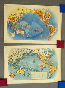
Sold2021Covarrubias Pacific Asia Pictorial Maps (2)Maps of the Pacific, Golden Gate International Exposition. NY, 1942. Miguel Covarrubias (1904-1957). 2 Maps: Peoples and Economy. Australia, Hawaii, Asia, Americas. .See Sold Price
Sold20181944 Western Pacific Railroad Pictorial Map of WesternTitle/Content of Map: 1944 Western Pacific Railroad Pictorial Map of Western US with Illustrations -- From San Francisco along the line of Western Pacific Railroad to Salt Lake City Date: 1944, DenverSee Sold Price
Sold2023ASSORTED EUROPEAN / AFRICAN PICTORIAL MAPS, LOT OF TWOASSORTED EUROPEAN / AFRICAN PICTORIAL MAPS, LOT OF TWO, engraving on paper, comprising a bird's-eye view of the siege of the town Oost Ende (Ostend), a Flemish town, during The Eighty Years' WSee Sold Price
Sold2021(PICTORIAL MAPS.) Miguel Covarrubias. Pageant of the(PICTORIAL MAPS.) Miguel Covarrubias. Pageant of the Pacific. Set of 6 large offset color lithographed maps. 25x38 and 19x25 inches each sheet size; without portfolio or descriptive pamphlet; soft verSee Sold Price
Sold2021San Diego with pictorial recreation map 1935Heading: (California - San Diego) Author: Title: Map of San Diego California City and County - with two maps, one a pictorial bird's-eye map Place Published: [San Diego] Publisher:Lowell E. Jones <See Sold Price
Sold2018Fire Fountains and Other Volumes on Hawaii.[Hawaii] Fire Fountains and Other Volumes on Hawaii. Including Fire Fountains (Edinburgh, 1883) by Cumming, two vols. original pictorial cloth, frontispieces, two maps, plates, mild lean; The HawaiianSee Sold Price
Sold2022(PICTORIAL MAPS.) D.E. Bates. Cunard R.M.S. Caronia / Great African Cruise 1950.(PICTORIAL MAPS.) D.E. Bates. Cunard R.M.S. Caronia / Great African Cruise 1950. Color offset-printed pictorial map advertising the Caronia's route on a two-and-a-half-month's-long affair: departing NSee Sold Price
Sold2022(PICTORIAL MAPS -- INTOXICATION INFATUATION.) H.J. (Heinie) Lawrence. Map Showing Isle of Pleasure,(PICTORIAL MAPS -- INTOXICATION INFATUATION.) H.J. (Heinie) Lawrence. Map Showing Isle of Pleasure, Scale Two Fingers to the Drink. Offset color-printed map of an alcohol-obsessed land loaded with allSee Sold Price
Sold2021Ruth Taylor White Hawaii Pictorial Maps (4)Island of Hawaii. Maui. Oahu. Kauai. Set of 4 Cartographs. Printed by The Paradise of the Pacific for the Hawaii Tourist Bureau, Honolulu. C. 1935. Ex library..See Sold Price
Sold2019Two Maps by the Hydrographic Office U. S. Navy,Two Maps by the Hydrographic Office U. S. Navy, consisting of "South Pacific Ocean, Anchorages in the Fiji Islands, 1925, H. - 23 3/8 in., W. - 33 1/2 in.; together with "South Pacific Ocean, Plans inSee Sold Price
Sold2021Lewis and Clark Journals 1962 Limited Ed. ClubLewis and Clark Journals 1962 with maps. This is a two volume set with slipcase. The Limited Editions Club New York. Numbered '757' of 1500. 772 pp. Many color illustrations. Pictorial map covers. ExSee Sold Price
Sold2020Mora, Jo (1876–1947). Yosemite. 1931 (1949Mora, Jo (1876–1947). Yosemite. 1931 (1949 reissue). Colorful pictorial map of Yosemite National Park. This is the second color printing, with two men running from a skunk in place of the CoulteSee Sold Price
Sold2023Cowrie ShellsTwo Map Cowrie shells; Largest measures approximately 90mm; From the private collection of a U.S. military officer stationed in the Pacific, circa 1960-1980;See photosSee Sold Price
Sold2017Sheridan's Personal Memoirs 1888Philip H. Sheridan. Personal Memoirs. NY: Webster, 1888. Large 8vo. Two volumes. Title page and adjacent pages in volume I loose. Numerous folding and other maps. Pictorial gilt binding has surface weSee Sold Price
Sold20222-Union Oil & 1-Pacific Coast Highway Road Mapsrated 6 to 8, 9"x4" or less in size, Pacific Coast map is in good condition, other two have light wear and soiling.See Sold Price
Sold20182 MAPS FRAMED, SCOTLAND OF OLD, IRELAND, BULLOCK MAPSTwo framed maps, Scotland of Old and Ireland. Windowbox style frames. 1969 Bullock Pictorial Historical Map of Ireland - This is a delightful 1969 L.G. Bullock pictorial historical map of Ireland. BulSee Sold Price
Sold2022WWII Factual Chart of WWII World War Two Asiatic-Pacific Operations MapFACTUAL CHART OF WORLD WAR II Asiatic-Pacific Operations folder and chart / poster with Generals and Admirals. The folder is 14 x 15 inches tall. The folding map poster itself is 38 x 57 inches. 1st eSee Sold Price
Sold2023Hornaday (2) 19TH C. Hunting Books SIGNEDTwo (2) William Hornaday inscribed and signed illustrated books. Includes: 1) Two Years in the Jungle. 1886. Charles Scribner's Sons. 512 pp. with fold out map. Cloth pictorial covers. 2) The Man WhoSee Sold Price
Sold2020(JAPAN -- FAN MAPS.) Dai Nihon Zenkoku Saiken Dochu Ki.(JAPAN -- FAN MAPS.) Dai Nihon Zenkoku Saiken Dochu Ki. Woodblock map of Japan with decorative pictorial vignettes and distance tables in two parts. Approximately 6x20 inches each sheet size; originalSee Sold Price
Sold2020New Tracks In North America 1stNew Tracks In North America A Journal of Travel and Adventure Engraved in the Survey for a Southern Railroad to the Pacific Ocean During 1867 - 1868. Two volume set. NumerSee Sold Price
Jun 13Swann Auction Galleries(PICTORIAL MAPS.) Two early twentieth-century pictorial maps of Santa Barbara, California.$450
Jun 13Swann Auction Galleries(PICTORIAL MAPS.) John Held, Jr. Motor Routes to "Real New England Inns".$600
Jun 27Rail & Road Auctions52 Pieces of Union Pacific Railroad Ephemera - Pocket Calendars, Maps, Aluminum Coins, etc$30
BonhamsHARLEQUINADE - MANUSCRIPT FLAP-BOOK A seventeenth century manuscript pictorial flap-book 'Painte...£1,800
Jun 13Swann Auction Galleries(ART DECO.) Two early twentieth-century French albums of pochoir plates.$1,500
Jun 13Swann Auction Galleries(PHOTOGRAPHY -- STEREOVIEWS.) Carleton Watkins, J.J. Reilly, and others. Group of approximately 80$750
Jun 13Swann Auction Galleries(MIDDLE EAST.) David Roberts. The Holy Land, Syria, Idumea, Arabia, Egypt & Nubia.$1,500
BonhamsPOTTER (BEATRIX) The Tale of Timmy Tiptoes, 1911; The Tale of Pigling Bland, 1913, FIRST EDITION...£300
3 days LeftLeon GalleryVincenzo Maria Coronelli (1650-1718) - Asia Divisa Nelle sue Parti Secondo lo Stato Presente₱220,000
Jun 28Rail & Road AuctionsGroup of Fourteen Railroad Stock Certificates - Illinois Central, Denver & Rio Grande Western,$30
Jun 13Swann Auction Galleries(PICTORIAL MAPS.) Arthur Kelly David Healy. Dartmouth College Campus.$375
BonhamsTWO PICTORIAL PINCHBECK PAPERWEIGHTS, England, mid-19th century, both on turned wood base, an or...$100
Jun 13Swann Auction Galleries(PICTORIAL MAPS.) Amy Drevenstedt. The Flight of Charles A Lindbergh from New York to Paris$750
Jun 13Swann Auction Galleries(PICTORIAL MAPS.) Annie Olmstead Peet; and Roscoe W. Smith. Orange County Before 1810.$300
Jun 12Jasper52Cambridge "This immense & glorious work…" Kerry Lee folding pictorial map 1948$440


![[PACIFIC NORTHWEST]. Two pictorial maps of Oregon and Washi...: [PACIFIC NORTHWEST]. Two pictorial maps of Oregon and Washington. Including: -- PETRUCCELLI, Antonio (1907-1994). Pictorial map of Washington and Oregon. 1940. Art Deco style map of the Pacific Northw](https://p1.liveauctioneers.com/928/255324/132836177_1_x.jpg?height=310&quality=70&version=1658268357)


![[AVIATION]. Two pictorial maps. Includes: CHEESEMAN, F.E. A...: [AVIATION]. Two pictorial maps. Includes: CHEESEMAN, F.E. Aviation Panorama. 1943. Milwaukee: Albert Richard Company. Colorful pictorial map in “Tribute to the Pioneer Spirit, the Inventive Geni](https://p1.liveauctioneers.com/928/305275/163151863_1_x.jpg?height=310&quality=70&version=1697054833)

![[PICTORIAL MAPS]. Two maps. Includes: JANNOT, J.B. (“Jan Lo...: [PICTORIAL MAPS]. Two maps. Includes: JANNOT, J.B. (“Jan Loup”). Grand Circuit Des Capitales. France: Agence Francaise de Propagande. Promotional map of Europe and Asia for Menier chocolat](https://p1.liveauctioneers.com/928/305275/163151899_1_x.jpg?height=310&quality=70&version=1697054833)


![San Diego with pictorial recreation map 1935: Heading: (California - San Diego) Author: Title: Map of San Diego California City and County - with two maps, one a pictorial bird's-eye map Place Published: [San Diego] Publisher:Lowell E. Jones <](https://p1.liveauctioneers.com/642/218849/112379283_1_x.jpg?height=310&quality=70&version=1631923877)
![Fire Fountains and Other Volumes on Hawaii.: [Hawaii] Fire Fountains and Other Volumes on Hawaii. Including Fire Fountains (Edinburgh, 1883) by Cumming, two vols. original pictorial cloth, frontispieces, two maps, plates, mild lean; The Hawaiian](https://p1.liveauctioneers.com/928/124137/63148761_1_x.jpg?height=310&quality=70&version=1530051387)