Sold2023RARE WWII British Cloth Escape Maps European Theater 1943 Series #43 C/D.WWII British Cloth Escape Maps European Theater 1943 Series #43 C/D. This Silk map is in Excellent Condition as pictured. Side C has maps of Holland, Belgium, France and Germany while Side D has mapsSee Sold Price
Sold2024Prewar Antique Silk Double Sided Map of Europe Germany France Belgium HollandPrewar Antique Silk Double Sided Map of Europe Germany France Belgium Holland. Measurements in inches: 29 x 28 1/2 Condition:Has browning along one edge on both sides of map Shipping:We offer in-houseSee Sold Price
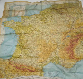
Sold20162 maps on silk2 maps on silk including Holland-Belgium-France-Germany; & Zones of France second edition. Stains; Measures 19 1/2 inches x 21 1/2 inches; & 29 inches x 27 1/2 inches.See Sold Price
Sold2021Pilot's Silk map, double sidedTitle: Pilot's Silk map, double sided Date: 1940's Medium: Silk Description: Pilot's Silk map, two sided depicting France, Belgium, Holland, the Pyrenees, Spain and German-Swiss frontier Genre: WorldSee Sold Price
Sold2017Homann: Antique Map of Belgium Holland Germany FranceTitle: Map of Belgium, Holland, Germany, and France by Homann Date: c 1747 Medium: Hand Colored Copper Plate Engraving Dimensions (in.): 22.5 x 20 No Reserve: This lot starts at $1 and has no reserveSee Sold Price
Sold20181944 British Air Force Escape Map (C & D) of France,Reserve Reduced! Title/Content of Map:1944 British Air Force Escape Map (C & D) of France, Benelux, Switzerland and Germany -- Sheet C Holland, Belgium, France (Northeast), Germany (West & Central) [vSee Sold Price
Sold2021Barclay, James C1835 Lot of 4 Hand Col Europe MapsGermany, Holland/Belgium, France and Spain/Portugal. Hand Colored Steel Engraved Maps Published C1835, London for "A Complete and Universal English Dictionary" by the Rev. James Barclay et al. EngraveSee Sold Price
Sold2023WWII Well-Traveled USO Related Baseball - Inscribed J. Roy StocktonOf both baseball and WWII interest. Inscribed, "Baseball flew the… twice with the USO and was in France, Belgium, Holland, Luxembourgh, and Germany. J. Roy Stockton". Official 1930's-40's NationSee Sold Price
Sold2024Central Europe roads canals railways Germany, Holland & Belgium. HUGHES 1854 mapCAPTION PRINTED BELOW PICTURE: 'Map of Central Europe, embracing Germany, Holland, Belgium, with parts of France & Switzerland; showing the roads, canals and railways' DATE PRINTED: 1854 IMAGE SIZE: ASee Sold Price
Sold2022WWII 1945 87th Infantry Division Framed Battle Operations MapWWII 1945 87th Infantry Division Framed Battle Operations Map. Route of the Golden Acorn Division: France, Luxembourg, Belgium, Germany, and Czechoslovakia. Approximate size is 19 x 29 inches. NicelySee Sold Price
Sold2022Universal Atlas 1893 Lot of 22 Maps of EuropeIncl Ireland, Ethnographic, France, Belgium/Luxemburg, Holland, Denmark, Germany, Austria/Hungary, Greece, Italy, Scandinavia, Norway/Sweden, Bohemia, Sicily/Sardinia etc. Lithograph Maps Published 18See Sold Price
Sold2021Tallis, John (Pub) 1852 Lot of 12 European MapsIncl Northern Italy, Southern Italy, Brussels, Germany, Spain and Portugal, Prussia, Europe Continent, Greece, Denmark, Belgium, Holland and France. Steel Engraved Maps with Original Outline Hand ColoSee Sold Price
Sold2020Bartholomew, John 1922 - 6 Maps. France Belgium HollandLarge Lithograph Maps Published 1922 by The Times, London for "The Times Survey Atlas of the World" Maps by John George Bartholomew of the Edinburgh Geographical Institute. Centre fold as issued. PapeSee Sold Price
Sold2017Malte-Brun: Map of North France Belgium & Holland, 1812Map: 1812 Malte-Brun Map of Northern France, Belgium and Holland -- Partie Septentrionale de l'Empire Francis Cartographer: M Malte-Brun Year / Place: 1812, Paris Dimensions: 8.7 X 11.7 in. Condition:See Sold Price
Sold2023WWII U.S MILITARY WAR MAPS OF FRANCE/BELGIUM - (9)171281 WWII U.S MILITARY WAR MAPS OF FRANCE/BELGIUM - (9) WWII U.S. military war maps of France/Belgium to include one sheet 79 Defenses Vierville-Sur-Mer France (12500) war map, two sheet 31/18 S.E.See Sold Price
Sold2020European stamp collection on approx 50 loose sheets.European stamp collection on approx 50 loose sheets. Mostly over 70 years old. Includes Austria, Belgium, France, Germany, Holland, Italy, Spain, Switzerland. We combine postage on multiple winning loSee Sold Price
Sold2023Barclay & Findlay 1834 Lot of 3 Maps. Holland, France and GermanySteel Engraved Map Published 1834 by Thomas Kelly, London for "A New and Universal English Dictionary" by the Rev. James Barclay. Maps Drawn & Engraved by Alexander Findlay. Paper Size: 10.5 x 8 inchSee Sold Price
Sold2019Bryce, James 1881 Mixed Lot of European MapsIncl Europe Continent, Britain under Saxons/Romans, Russia, Italy, Spain/Portugal, Swtizerland, Holland/Belgium, and France. Lithograph Maps Published 1881, London for ""The International Atlas and GeSee Sold Price
Sold2024Johnson's France, Holland & Belgium. 2 maps on one sheet. Benelux 1861 oldCAPTION PRINTED BELOW PICTURE: 'Johnson's France // Johnson's Holland and Belgium' DATE PRINTED: 1861 IMAGE SIZE: Approx 42.5 x 65.5cm, 16.75 x 25.75 inches (Large); Please note that this is a foldingSee Sold Price
Sold2016A Collection of European Currency.A Collection of European Currency. France, Germany, Holland, Ireland, England, Belgium, and other countriesSee Sold Price
Sold2023WWII 6TH AD AACHEN ORIGINAL MILITARY FIELD MAP170298 WWII 6TH AD AACHEN ORIGINAL MILITARY FIELD MAP WWII 6th armored division Aachen Germany/Belgium original field map. Size: 20 X 26" Provenance: United StatesCondition: Perimeter slightly worn.See Sold Price
Sold2021A World War II Air Ministry printed silk escape map ofA World War II Air Ministry printed silk escape map of Germany (issued for downed airmen and Prisoners of War), 36 x 45 cm, framed and glazedSee Sold Price
Sold2020Original WWII U.S. Army Silk Evasion MapsOriginal WWII U.S. Army Silk Evasion Maps - Offered Without Reserve - There is NO ESTIMATE on this item. - Vintage Original WWII U.S. Army Silk Evasion Maps for Aviators Depicting Central FranceSee Sold Price
Sold2023WWII March 1944 Zones of France Silk Escape MapMarch 1944 Original silk escape map of France. This would be the type of item carried by US Paratroopers during the Invasion of Normandy, as well as US aviators flying missions over France.See Sold Price
3 days LeftJasper521792 Elwe Map of Southern Netherlands to Belgium to Northern France -- Carte Nouvelle des Pais Bas$80
3 days LeftJasper521579 Ortelius Map of Parts of Belgium and Holland -- Brabantiae, Germaniae Inferioris Nobilissimae$160
3 days LeftJasper521792 Elwe Map of the Netherlands and Belgium -- Les Dix-Sept Provinces des Pays-Bas$80
5 days LeftSwann Auction GalleriesDESIGNER UNKNOWN. CACAO VAN HOUTEN. 1903. 29½x21½ inches, 75x54½ cm.$500
May 19Frasher's Doll AuctionPETITE, SIZE 0, SONNEBERG BISQUE DOLL BY WILHELM DEHLER FOR THE FRENCH MARKET$900
May 19Frasher's Doll AuctionTINY GERMAN BISQUE MIGNONETTE IN PRESENTATION BOX WITH TROUSSEAU$600(1 bid)
Featured4 days LeftJasper52French Impressionist Oil Painting Potted Plant and Bright Garden c.2000$240
4 days LeftJasper52Bright & Colorful French Impressionist Oil Painting - Flowers & Fruit c. 2000$1,700