Sold20231915 Chart of the Coast of New York and ConnecticutCoast chart by the US Coast and Geodetic survey from the Stratford Shoal to New York. Long island sound. Coast Chart number 116. Covering Stratford, Bridgeport, college point, Westport, Norwalk, StratSee Sold Price
Sold2017Ferrer: Antique Nautical Chart of St. Mary's, 18091809 Nautical Chart of St. Mary's & Cumberland Island, Georgia. Original engraving from José Joaquín de Ferrer y Cafranga's sea atlas, the 'Portulano de los Estados Unidos', published in Madrid in 1See Sold Price
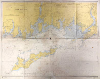
Sold2020Land Ho! Antique Fishers Island Sound, RI-CT-NY USCGDescription: Ahoy! Antique Coast Guard nautical chart of Fishers Island Sound, RI-CT-NY. Numbered C. & G. S. 358; published 1968. Material: paper. Measurement: approximate 36" x 45" (INCHES). ShippingSee Sold Price
Sold2019Land Ho! Antique Block Island Sound, RI USCGDescription: Ahoy! Antique U.S. Coast Guard nautical chart of Block Island Sound and Approaches. Numbered C. & G. S. 1211; published 1968. Material: paper. Measurement: approximate 36" x 41" (INCHES).See Sold Price
Sold2021Fishers Island Sound, RI-CT-NY USCGFishers Island Sound, RI-CT-NY USCG, Coast Guard nautical chart of Fishers Island Sound, RI-CT-NY. Numbered C. & G. S. 358; published 1968. Approximate measurements: 36" x 45" (INCHES) Materials: PapeSee Sold Price
Sold2024CHART "SOUTHERN COAST OF LONG ISLAND FROM MONTAUK POINT TO EAST HAMPTON" Circa 1877 11.25" x 22.75"CHART "SOUTHERN COAST OF LONG ISLAND FROM MONTAUK POINT TO EAST HAMPTON"Circa 187711.25" x 22.75" sight. Framed 16.75" x 28". Provenance:An Important Connecticut Collection.See Sold Price
Sold2023Nautical Chart: SOUTHERN COAST OF LONG ISLAND SOUND/ MONTAUK POINT TO EAST HAMPTONDescription: SOUTHERN COAST OF LONG ISLAND SOUND/ FROM MONTAUK POINT TO EAST HAMPTON Measurement approximate: 32 x 22 InchesMaterial: PaperSee Sold Price
Sold2016Original Imray & Son S. America Coast Chart, 1877Nautical Chart of South American coast, between Rio de la Plata and Valparaiso. Details include Cape Horn Islands, South Shetlands, Falklands, Southern tip of South American coast including Chile andSee Sold Price
Sold2022FULLER, CAPTAIN WILLIAM; JEFFERYS, THOMAS; and DE BRAHM, WILLIAM GERARD Plan of Amelia Island inFULLER, CAPTAIN WILLIAM; JEFFERYS, THOMAS; and DE BRAHM, WILLIAM GERARD Plan of Amelia Island in East Florida [and] A Chart of the Entrance into St. Mary's River...[and] A Chart of the Mouth of NassauSee Sold Price
Sold2017Ferrer: Antique Nautical Chart of Nassau River, 18091809 Nautical Chart of Nassau River and Part of Amelia Island and Talbot Island (Florida). Original engraving from José Joaquín de Ferrer y Cafranga's sea atlas, the 'Portulano de los Estados UnidosSee Sold Price
Sold2019A.D. Bache U.S. Coast Survey Charts East CoastA.D. Bache: Preliminary Coastal Chart N. 8, Sequin Island to Kennebunkport, Maine 1859. Measures 38” X 22”. Paper size 40" x 24 1/2". Used Condition, creases, burn. electrotype have some sSee Sold Price
Sold2023NAUTICAL CHART: RHODE ISLAND/ PROVIDENCE HARBORDescription: UNITED STATES - EAST COAST RHODE ISLAND/ PROVIDENCE HARBORMeasurement approximate: 30 x 37 Inches Material: PaperSee Sold Price
Sold2016Eldridges chart of Long Island SoundLater copy of an 1875 chart of Long Island Sound as drawn by George Eldridge, Hydrographer. Chart shows the coast of Long Island Sound from Mamaroneck New York to Newport Rhode Island. Other ports shoSee Sold Price
Sold2019West-Indies – Bahama’s, Turks Island, British AdmiraltyDetailed, unused and early chart of the coast of Turks Island. The first surveys are from 1830 by Captain R. Owen. With tidal information. Authentic, very detailed sea chart, no modern copy. On thickSee Sold Price
Sold2016Chart of Long Island SoundLater copy of a 1875 Eldridge chart of Long Island Sound from Newport to New York. Showing all ports on Long Island Sound, right on the coast of Connecticut to Newport, and the north coast of Long IslSee Sold Price
Sold20241879 CHART OF LONG ISLAND SOUNDFrom the survey of the coast of the US, by C. Patterson Superintendent, 26 inches by 105 inchesSee Sold Price
Sold2023NAUTICAL CHART/ CONNECTICUT NEW YORK. NORTH SHORE OF LONG ISLAND SOUND GREENWICH POINT TO NEWDescription: NAUTICAL CHART EAST COAST/ CONNECTICUT – NEW YORK. NORTH SHORE OF LONG ISLAND SOUND GREENWICH POINT TO NEW ROCHELLE. Published at Washington D.C/ JUNE 1939 (6TH Edition) First editSee Sold Price
Sold2023NAUTICAL CHART/ CONNECTICUT NEW YORK. NORTH SHORE OF LONG ISLAND SOUND GREENWICH POINT TO NEWDescription: NAUTICAL CHART EAST COAST/ CONNECTICUT – NEW YORK. NORTH SHORE OF LONG ISLAND SOUND GREENWICH POINT TO NEW ROCHELLE. Published at Washington D.C/ JUNE 1939 (6TH Edition) First editSee Sold Price
Sold2018U.S Coast Survey 1853 Map. Ship Island Shoal, Louisiana"Preliminary Chart of Ship Island Shoal Louisiana" Electrotype Map Published 1843-65, Washington for "Report of the Superintendent of the U.S. Coast Survey..." Published under the supervision and direSee Sold Price
Sold2021Nautical Map / Sea Chart, #362 Block Island Sound andDescription: Nautical Map / Sea Chart, United States East Coast, New York, Long Island, Block Island Sound and Gardiner's Bay, 6th edition, Feb 10/69; Shipping: $20; different rate to California, AlasSee Sold Price
Sold2020Bellin: Isla del Carmen (Port Royal Island), MexicoBellin's attractive chart of the island of Port Royal (today Isla del Carmen), the Laguna de Terminos and the surrounding coast of Campeche Bay, with many place names and topographical details, includSee Sold Price
Sold2020Nautical Map / Sea Chart, #1211 MarthaDescription: Nautical Map / Sea Chart, United States East Coast, Rhode Island - Connecticut - New York, Block Island Sound and Approaces9th edition, dec 23/63 stamped CORRECTED ONLY FOR AIDS & HAZARDSSee Sold Price
Sold2019United States East Coast – Block Island, Nantucket,Title: United States East Coast – Block Island, Nantucket, Rhode Island British Admiralty Chart 2492, published 1887 Date: 1887 Cartographer: British Admiralty Size: 28x41 in Hardly used, small scalSee Sold Price
Sold20221866 Chart of San Juan Island in Washington --Title: 1866 Chart of San Juan Island in Washington -- Washington Sound and Approaches Washington Territor Cartographer: US Coast Survey Year / Place: 1866 Map Dimension (in.): 17.5 X 16 in. This superSee Sold Price
4 days LeftZikorn Arts & History ObjectsWest Indies, Western Cuba 1879 British Admiralty Nautical Map$100
Featured3 days LeftJasper52Chart of the Sea Coasts of England, Flanders & Holland. MOUNT & PAGE 1758 map$420
1 day LeftFleischer's Auctions1755 Map Partie de l'Amerique Septentrionale, qui comprend Le Cours de L'Ohio...$200(3 bids)
Featured2 days LeftJasper52Pair Griswold Cabinets, Armoire's, Dessin Fournir, Chinoiserie, Palatial$42,000
2 days LeftJasper52Pair Custom Chesterfield Tufted Loveseats, Settees, Couches, Velour, Georgian$4,200
2 days LeftUniversity ArchivesCadet George S. Patton Jr. Writes to Future Wife about Life at West Point$1,000
4 days LeftZikorn Arts & History ObjectsCentral America West Coast 1855 British Admiralty Nautical Chart$100(1 bid)
7 days LeftUkiyoe Gallery Japanese Woodblock PrintsHasui Kawase: Enoshima Beach 1933 Woodblock$125(2 bids)
6 days LeftOakridge Auction GalleryAn Chinese apricot yellow-ground embroidered 'floral' seat cover, 19th century$100
7 days LeftUkiyoe Gallery Japanese Woodblock PrintsIshii Ryosuke: Riding Horses Oshima Island Woodblock NR$30
May 26GOLDEN SUN AUCTIONS, Inc. (formerly Appraisal & Estate Sale Specialists, Inc.)(16) 1994-95 Kenner/Toy Island The Mask Action Figs-MIP-NOS$40
May 26GOLDEN SUN AUCTIONS, Inc. (formerly Appraisal & Estate Sale Specialists, Inc.)(5) Hot Wheels Oil Can '57 Chevy Funny Car-Ltd Ed-MIP-NOS$20
3 days LeftHeritage Auctions74058: A Set of Three Gorham Mfg. Co. Silver and Mixed $600
6 days LeftOakridge Auction GalleryA Chinese midnight-blue-ground goldwork 'dragon' and 'lion' chair cover, 19th century$500
7 days LeftUkiyoe Gallery Japanese Woodblock PrintsIshii Ryosuke: Women at a Well, Oshima Woodblock NR$30
3 days LeftHeritage Auctions74225: A Six-Piece Gorham Mfg. Co. Plymouth Pattern Sil$1,300(1 bid)


![FULLER, CAPTAIN WILLIAM; JEFFERYS, THOMAS; and DE BRAHM, WILLIAM GERARD Plan of Amelia Island in: FULLER, CAPTAIN WILLIAM; JEFFERYS, THOMAS; and DE BRAHM, WILLIAM GERARD Plan of Amelia Island in East Florida [and] A Chart of the Entrance into St. Mary's River...[and] A Chart of the Mouth of Nassau](https://p1.liveauctioneers.com/292/250642/130213561_1_x.jpg?height=310&quality=70&version=1654271664)


