Sold2021HERMAN MOLL English Empire EngravingHERMAN MOLL English Empire Engraving, inscription reads ‘The English Empire in America, Newfoundland Canada Hudson’s Bat Herman Moll Fecit’, subject a map of the British empire, measures 14 1/8See Sold Price
Sold2023HERMAN MOLL (ENGLISH, C. 1654-1732) MAP OF NORTH AND SOUTH CAROLINAHERMAN MOLL (ENGLISH, C. 1654-1732) MAP OF NORTH AND SOUTH CAROLINA, hand-colored engraving on laid paper, titled "CAROLINA / By / H. Moll Geographer" in a rectangular cartouche along lSee Sold Price
Sold2021Collection of Antique Maps of North AmericaA framed collection of nine small maps including "The English Empire in America, Newfound-Land, Canada, Hudsons Bay &c. in Plano" by Herman Moll circa 1709 and "North America from the Best AuthoritiesSee Sold Price
Sold2016America by Herman Moll 1716Map Title: America, According to the Newest and Most Exact Observations Maker: Herman Moll Date: 1716 Origin: Atlas Geographicus Size: 13 x 16 inches Medium: Copperplate engraving Herman Moll (1654-17See Sold Price
Sold2016Carolina & Bermuda 1716Map Title: Carolina & The Island Bermudos Maker: Herman Moll Date: 1716 Origin: Atlas Geographicus Size: 13 x 16 inches Medium: Copperplate engraving Herman Moll (1654-1732) was a London cartographer,See Sold Price
Sold2016Map of Barbados, 1716Original copper engraving by Herman Moll published in Atlas Geographicus, London, 1716. Dimensions: 13" x 16" Shipping Domestic: Shipping rates are determined by destination. International: Foreign shSee Sold Price
Sold2017Moll: Map of Poland, 1701Map of Poland. An original copperplate engraving published by Herman Moll in 1701. With text describing the Kingdom Of Poland. 7 x 7.5 " (map only) Please note that this lot has a reserve. When you leSee Sold Price
Sold2023Asia by Herman Moll. Great Wall of China. Mogol empire. Tartaria 1709 old mapTitle: Asia by Herman Moll. Great Wall of China. Mogol empire. Tartaria 1709 old map Description: Asia' by Herman Moll (1709). Antique copperplate map, 29.5 x 19.5cm, 11.5 x 7.75 inches The mythical lSee Sold Price
Sold20231729 Map of New England, New York, Herman Moll1729 English Map of New England, Herman Moll (1654-1732). Map titled, "NEW ENGLAND NEW YORK NEW JERSEY and PENNSYLVANIA". Map with detailed depiction of the North East, with hand coloring. Good conditSee Sold Price
Sold2016Straights of Magellan by Herman Moll, 1716Original copper engraving of Straights of Magellan published in Atlas Geographicus by Herman Moll, London, 1716. Dimensions: 11 1/2” x 19 1/2” Shipping Domestic: Shipping rates are determind by deSee Sold Price
Sold2023Herman Moll, Map of Bermuda, 1729Herman Moll, Map of Bermuda, 1729, "The Island of Bermudos Divided into its Tribes, with the Castles, Forts, &c", hand-colored engraving on paper, gallery stamps verso, matted and framed under glass,See Sold Price
Sold20241784 Herman Moll "Bowles's Geographica Classica or the Geography of the Ancients"as contained in the greek and latin classics, exhibited in 32 maps showing the several empires, kingdoms, and provinces, the chief cities, towns, rivers and mountains mentioned in Homer, Herodotus, JuSee Sold Price
Sold2020Grp: 5 Maps of Germany Europe and the MediterraneGroup of five 18th century maps. This group includes a hand colored map of Germany by Herman Moll (ca. 1654-1732); one map of the Turkish empire by Tobias Conrad Lotter (1717-1777); one map of the BriSee Sold Price
Sold2023AMERICA H. Moll Geographer 1732 MapHerman Moll 1732 Map of the Americas, North and South America with California depicted as an island. Hand Colored engraving 8 1/2 x 11 in Matt.See Sold Price
Sold2022Moll, Plan of Port Royal Harbour in Carolina 1730-32Property from the Collection of John and Virginia Duncan, Savannah, GA Description: Herman Moll (1654-1732), A Plan of Port Royal Harbour in Carolina, Engraving, 1730-32, A Plan of Port Royal HarbSee Sold Price
Sold2021A GROUP OF TWO 18TH CENTURY MAPS OF THE AMERICAS,A GROUP OF TWO 18TH CENTURY MAPS OF THE AMERICAS, LONDON AND PARIS, 1736-1780, two hand-colored engravings on paper, comprising, "FLORIDA Called by ye French LOUISIANA," after works by Herman Moll (16See Sold Price
Sold2022JOHN SPEED MAP OF HUNTINGTONBOTH SHIRE & SHIRE TOWNE, WITH THE ANCIENT CITIE ELY DESCRIBED Copper-plate engraving, published George Humbell,1623. From The Theatre of the Empire of Great Britaine, with English text on verso. cf.See Sold Price
Sold20231702 Antient & Present State of the Empire of Germany antique w/ MAP in ENGLISHThe Antient and Present State of the Empire of Germany... London, 1702 With 1 map and a frontispiece copper engraving. Original leather binding, covers are reinforced inside of the endpapers Very goodSee Sold Price
Sold2022BEAVER MAP, HERMAN MOLL (DUTCH/BRITISH, 1654-1732)A New and Exact Map of the Dominions of the King of Great Britain on ye Continent of North America containing Newfoundland, New Scotland, New England, New York, New Jersey, Pensilvania, Maryland, VirgSee Sold Price
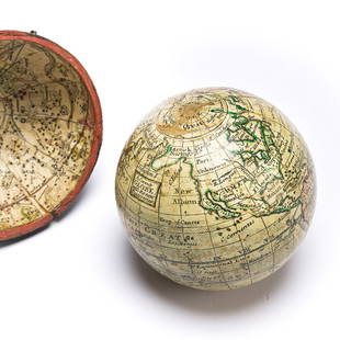
Sold2023(GLOBES.) Style of Herman Moll. A Correct Globe with the New Discoveries.(GLOBES.) Style of Herman Moll. A Correct Globe with the New Discoveries. 2¾-inch miniature terrestrial pocket globe comprised of 12 hand-colored engraved gores and 2 polar calottes on a plasterSee Sold Price
Sold2024Map of the North Parts of America Claimed by France by Herman Moll (London, 1720)Map of the North Parts of America Claimed by France by Herman Moll (London, 1720) "A New Map of the North Parts of America claimed by France under ye Names of Louisiana, Mississippi, Canada, and New FSee Sold Price
Sold2020Herman Moll Emanuel Bowen "A Complete System of GHerman Moll (ca. 1654-1732) and Emanuel Bowen (1694-1767), "A Complete System of Geography," London, 1747. Volumes I and II. The title page reads: "A Complete System of Geography. Being a DescriptionSee Sold Price
Sold2017FRAMED WORLD MAP BY HERMAN MOLL, 1719'A New & Correct Map of the Whole World, by Herman Moll, Geographer, 1719.' Hand tinted and framed. Frame size: 73 x 124 cm (28 3/4 x 48 3/4 in.)See Sold Price
Sold2019Herman Moll 1654-1732), "A New And Correct Map of theHerman Moll 1654-1732), "A New And Correct Map of the World," 1710, hand colored, H. - 22 in., W. - 38 in.See Sold Price
4 days LeftHess Fine AuctionsAntique Mid Victorian Hand Colored Portrait Engraving Transitional Empire To Victorian France$10
5 days LeftJasper52English Antique Woodcut Engraving, Signed, of Prose by Robert Bridges Circa 1920-1930$120
4 days LeftJasper521858 INDIA HISTORY ILLUSTRATED antique Geographical, Statistical, and Historical$70
2 days LeftThousand Planet Auction HouseAn Ancient Seljuk Era Silver Floral Engraved Bead, 11th-12th Century AD$5
Jun 02Tremont Auctions1767 English sterling silver coffee pot. Armorial engraving of a beast with cross on its chest.$300
22 hrs LeftRichard Stedman Estate Services LLCEnglish Gainsborough Era Romantic 11in x 9in Lady Gown Portrait Lawrence Raeburn Manner Early 19c$200(1 bid)


![[MAP]. SPEED, John. A New Mappe of the Romane Empire. 1676. (1 of 2)](https://p1.liveauctioneers.com/197/329395/177650541_1_x.jpg?height=282&quality=70&version=1715364962)


