Sold2021Two Framed West Hartford, Connecticut Maps with handTwo Framed West Hartford, Connecticut Mapswith hand coloring by L.J. Richards of West Hartford, Connecticutcirca 1890's24" x 34" framedSee Sold Price
Sold2021A GROUP OF TWO MAPS, LOUISIANA AND NEW ORLEANS, EARLYA GROUP OF TWO MAPS, LOUISIANA AND NEW ORLEANS, EARLY 20TH CENTURY, comprising, "The RAND-McNALLY New Commercial Atlas Map of New Orleans," 1912, page 238, from Commercial Atlas Map of America, a reisSee Sold Price
Sold20202 Maps of Sardinia and Corsica Mercator and HondiGroup of two maps of Sardinia and Corsica. Gerardus Mercator (1512–1594) and Jodocus Hondius (1563–1612), a hand colored map of Sardinia and Corsica, Amsterdam, 1607. From Atlas Minor GeSee Sold Price
Sold2020Grp: 10 Maps of British Cities w/ 1 Map VeniceGroup of maps of British cities. Includes one map of Birmingham; two road maps for the London area: "A Map of the New Roads & c. from Westminster Bridge" and "A Plan of the intended New Road from PadiSee Sold Price
Sold2016Atlas Of Hartford City And County, With a Map ofAtlas Of Hartford City And County, With a Map of Connecticut, Published by Baker & Tilden, Hartford, Conn., 1869, 15" x 18", having brown textured cloth boards with title on font cover. Note: Atlas apSee Sold Price
Sold2019Group of Early Maps of New Mexico(1) Rand, McNally & Co.'s New Commercial Atlas of America - Map of New Mexico. Copyright, 1911, by Rand, McNally & Co. 23 3/4 x 31 1/4 inches (2) Geologic Map of New Mexico. Two-part folding map. PartSee Sold Price
Sold2022Road Atlases, Maps, Books With Mineral AreasIncluded are maps and books of geology and mineral resources in North Carolina, AAA road maps of Colorado and Wyoming, two road atlases for Baltimore County and New Hampshire. Some areas are denoted aSee Sold Price
Sold20242 VOLUMES, FOLIO, THE COMPLETE ATLAS OF MODERN CLASSICAL, AND CELESTIAL MAPS, 1873The Complete Atlas of Modern Classical and Celestial Maps, in two Volumes. London: Edward Stanford. 1873. Folio. For display and reference in your library. Condition as shown. Group: 17.75" x 14.5" xSee Sold Price
Sold2019Meyer: New England with Boston & Other City InsetsReserve Reduced! The highly detailed, well colored map of the New England states from Meyer's Zeitungs-Atlas, with insets of the Boston, Hartford, and New Haven areas.; rs1401; Bibliographischen InstiSee Sold Price
Sold2020Grp: Mixed Atlas PagesLarge group of pages from a variety of early atlases. The majority are from two atlases: Mallet and "Della Geografia di Tolomeo." Maps from Mallet include including maps of Asia, eastern India, China,See Sold Price
Sold2023BOOK: Topographical Atlas of Connecticut by the United States Geological Survey, 1893, Hartford,BOOK: Topographical Atlas of Connecticut by the United States Geological Survey, 1893, Hartford, 1893, thirty-three topographical maps, as issued, large folio, covers warped and loose.See Sold Price
Sold20201842 map of New York City, Sidney MorseFrom the very first cerographic atlas ever published. Two tiny very lightly discolored areas at top edge; corner crease. 12 x 15. Reserve: $90.00 Shipping: Domestic: Flat-rate of $6.00 to anywhere witSee Sold Price
Sold2020[Maps & Atlases] [Africa] Ortelius, Abraham, Group of 2[Maps & Atlases] [Africa] Ortelius, AbrahamGroup of 2 MapsBarbariae et Biledulgerid, nova descriptio(Antwerp, ca. 1570-1612). Hand-colored engraving. Coastal map of North Africa and the Mediterranean,See Sold Price
Sold2021Jacques Nicolas Bellin MapsJacques Nicolas Bellin , "Plan de La Nouvelle Orleans" and "Carte des Embouchures du Mississipi", two hand-colored engraved maps, from Le Petit Atlas Maritime, 1764, 7 1/2 in. x 11 in., framed . ProveSee Sold Price
Sold2020EULER, LEONHARD. [Geographisher Atlas.]EULER, LEONHARD. [Geographisher Atlas.] Without title or text, 39 (of 44) double-page engraved maps with original hand-coloring (lacking the first two double-hemispheric maps, the XVII Provinces, andSee Sold Price
Sold2022Two railroad framed maps:Nickel Plate - the New York, Chicago, St. Louis RR, 18"x34", AND Detroit United Railways Interurban Lines, 11"x34"See Sold Price
Sold2022SENEX, JOHN. Group of 25 full-sheet and double-page engraved maps in fine original hand-color.SENEX, JOHN. Group of 25 full-sheet and double-page engraved maps in fine original hand-color. 12 large two-sheet double-page maps measuring approximately 40x26 inches each; 13 unfolded full-sheet mapSee Sold Price
Sold2022Map of the Possessions angloises et françoises de l'Amérique septentrionale - 1755Map of the Possessions angloises et françoises de l'Amérique septentrionale (1755) Description: Two pages of an atlas mounted on paper, cartouche: Map of the English and French possessioSee Sold Price
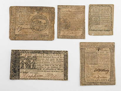
Sold2020Continental and colonial Currency: Mixed groupIncludes a $4 Continental note dated July 22, 1776, a $6 Maryland Note: 1774, 3 pence Hartford Connecticut Note: October 11, 1777, Pennsylvania April 1777 3 pence note, and a Two Shillings and Six PenSee Sold Price
Sold2022Four Piece Watercolor Group by F. Richardson MurrayFour Piece Watercolor Group by F. Richardson Murray (20th century), to include Outskirts of Hartford, Connecticut; Seminole Village of Miami, Florida; Georgia, lunch room cityscape; two signed in pencSee Sold Price
Sold2024RARE 1638 HONDIUS MAP OF BERMUDA, FRAMEDHenricus Hondius (1597-1651): "Mappa Aestivarum Insularum, alias Barmudas." First atlas issue, two joined sheets as issued, copperplate engraving on wove paper with original contemporary color, printeSee Sold Price
Sold2022VARIOUS ARTISTS. [ILLUSTRATED MAPS]. Group of 3 posters. 1930s-1940s. Sizes vary.VARIOUS ARTISTS [ILLUSTRATED MAPS]. Group of 3 posters. 1930s-1940s. Sizes vary. Condition varies, generally A- / A. Group includes: A Map of Western Long Island (1939), by Rolf Klep; Michigan / UpperSee Sold Price
Sold2023WWII U.S MILITARY WAR MAPS OF FRANCE/BELGIUM - (9)171281 WWII U.S MILITARY WAR MAPS OF FRANCE/BELGIUM - (9) WWII U.S. military war maps of France/Belgium to include one sheet 79 Defenses Vierville-Sur-Mer France (12500) war map, two sheet 31/18 S.E.See Sold Price
Sold2022Petrus Kaerius and Abraham Ortelius, Two Vintage MapsPETRUS KAERIUS and ABRAHAM ORTELIUS (Flemish, 1571-1646), and (Belgian, 1527-1598), Orbis Terrarum Typus De Integro Multis In Locis Emendatus auctore Petro Kaerio anno 1607, and Indiae Orientalis InsuSee Sold Price
23 hrs LeftJasper521867 Beers Map of New York City Area -- Map of New York and Vicinity Accompanying "Atlas of New York$200
2 days LeftDoyle New YorkPresident Lincoln discharges two Confederate prisoners two conscripted confederate soldiers asking$3,500
7 days LeftWinter Associates ASIAN: Two wood block prints by Katsushika Hokusai (Japanese 1760-1849) "Snow on the Sumida River"$150(1 bid)
7 days LeftWinter Associates +CLOCK: Connecticut shelf clock, c. 1835, column and cornice two deck clock, mahogany, case labeled$75
May 12Schilb Antiquarian Rare Books1869 ATLAS 42 MAPS America Africa Australia GERMANY Switzerland Sydow RARE$130(3 bids)
May 12Schilb Antiquarian Rare Books1881 Westchester County New York Yonkers Illustrated MAPS 2v SET Bolton History$26(3 bids)
May 14Akiba Galleries(2 Pc) Allain Manesson Mallet Description De L'Univers 2 Vol. German Translation$200(1 bid)
May 10Rail & Road AuctionsEleven Army Corps of Engineers Port Series No. 1 Through No. 8 Books with Fold Out Maps$35(2 bids)
1 day LeftAdam's AuctioneersCAREY'S General Atlas Improved and Enlarged, being a Collection of Maps of the World and Quarters,€2,600(2 bids)


![[Maps & Atlases] [Africa] Ortelius, Abraham, Group of 2: [Maps & Atlases] [Africa] Ortelius, AbrahamGroup of 2 MapsBarbariae et Biledulgerid, nova descriptio(Antwerp, ca. 1570-1612). Hand-colored engraving. Coastal map of North Africa and the Mediterranean,](https://p1.liveauctioneers.com/65/180189/90674454_1_x.jpg?height=310&quality=70&version=1601308774)

![EULER, LEONHARD. [Geographisher Atlas.]: EULER, LEONHARD. [Geographisher Atlas.] Without title or text, 39 (of 44) double-page engraved maps with original hand-coloring (lacking the first two double-hemispheric maps, the XVII Provinces, and](https://p1.liveauctioneers.com/199/171650/86487384_1_x.jpg?height=310&quality=70&version=1592430092)


![VARIOUS ARTISTS. [ILLUSTRATED MAPS]. Group of 3 posters. 1930s-1940s. Sizes vary.: VARIOUS ARTISTS [ILLUSTRATED MAPS]. Group of 3 posters. 1930s-1940s. Sizes vary. Condition varies, generally A- / A. Group includes: A Map of Western Long Island (1939), by Rolf Klep; Michigan / Upper](https://p1.liveauctioneers.com/199/255737/132982810_1_x.jpg?height=310&quality=70&version=1658424802)


![[MAP - TOURS] (1 of 1)](https://p1.liveauctioneers.com/292/326828/175962850_1_x.jpg?height=282&quality=70&version=1713473479)


