Sold2023After Michel Etienne Turgot, map of ParisAfter Michel Etienne Turgot, map of Paris, Fine quality reproduction of one of the 20 plates from the Turgot 1739 Plan of Paris, blind-stamp of the Musee de Louvre center lower margin, framed under glSee Sold Price
Sold2019Bretez-Turgot 1739 Plan de Paris Alphonse TarideBretez-Turgot 1739 Plan de Paris Alphonse Taride Alphonse Taride c. 1900 reissue of Bretez-Turgot 1739 “Plan de Paris”, which is possibly the most ambitious urban mapping ever undertaken.See Sold Price
Sold20241812 large French map of Paris plan routier de la Ville et faubourgLarge engraving of Paris and its surrounding area dated 1812 , cooper engraving in the manner of the Turgot map ,Jean Pierre printer , a Paris, chez Jean, Rue St Jean de Beauvais, N° 10, It is thSee Sold Price
Sold2022(Early 20th c) MAPS OF EUROPE / MANY WARTIMEBataille de la Marne, French and British Front 1917, Ordnance Surveys Loughborough, Derby, Rickmansworth, Nouveau Plan de Paris Monumental N.B. circa 1890, printed by Defrenoy (Paris, France), overallSee Sold Price
Sold2020Le Plan en Perspective de la Ville de Paris"Le Plan en Perspective de la Ville de Paris" after the 1734-1739 map by Louis Bretes and Claude Lucas, large facsimile engraving mounted on board and framed. sight 60-1/2" x 78", framed 67-3/4" x 85"See Sold Price
Sold20221966 Limited Edition Plan De Turgot1966 Limited Edition Plan De Turgot . A complete set of prints of maps of Paris.Dimensions: Booklet; 11" by 15" Prints; 15" by 22.25". Hardcover; 15.75" by 23.375" Shipping is the buyer's responsibiliSee Sold Price
Sold2023Vintage Framed Map of Paris1957 Blondel La Rougery Paris Map. Marked Plan De Paris A Vol D'Oiseau, Blondel La Rougery, Edit. Imp. 7, Rue Saint Lazare Paris 9e, Dressee Et Imprimee Par Blondel La Rougery, tous droits d reproductSee Sold Price
Sold2017Map of Paris Monuments Metropolitan Autobus, 1971Paris Map "Plan Commode de Paris/ Rues et Monuments Metropolitan Autobus". 1971. 4 x6 red boards. Paris Metro map tipped in at the front. Multi-fold map laid in, printed on both sides approx. 22 x 30,See Sold Price
Sold2019Georges Peltier, old map of ParisGeorges Peltier, old map of Paris, "Plan de Paris a vol dóiseau", c. 1920-1940, colored lithograph on paper, 32.5"h x 41.5"w (sight), 33.5"h x 42.5"w (frame) Provenance: The Estate of Huguette ClarSee Sold Price
Sold2022Plan de Paris 1927 Made for Washington Sq. BookPlan de Paris map by Ilonka Karasz printed for sale at the Washington Square Bookshop in 1927. Measures 27.5 in. x 36 in. and folds to 14 in. x 9 in. Loose in a leatherette folio. Color with gilt on tSee Sold Price
Sold2023Map LotLot (3) framed maps including "PLAN DU CENTRE DE PARIS VOLD' OISEU" (overall in frame 28" x 38 1/2"), Spain (overall 25" x 34 1/2"), "GALLACIA REGNUM" (overall 21" x 23").See Sold Price
Sold2017Bellin: Antique Plan of Cusco, 1754Map: Plan de Cusco Cartographer: Bellin Place & Date: Paris / 1754/1760 Size: 5 3/4" x 9 1/8" Condition: b&w; light overall age toning; a stain in the wide right margin; mounted on contemporary paperSee Sold Price
Sold2018Therbu: Guadeloupe in the Seven Years’ WarReserve Reduced! Title of Map: Plan de la Guadeloupe Cartographer: Therbu Place / Date: Paris / 1775 Size: 9 1/4" x 14" Condition: b&w; some fraying along outer edges of margins, otherwise in excellenSee Sold Price
Sold2024Poster "Les jardins de Paris", illustrated map and plan of Paris with its parcs, gardens, monuments,The "Gardens of Paris" poster has the same proportions as a modern map but is illustrated, as were the antique maps, in the same way that the "portulans" of the sixteen century were.With precisely depSee Sold Price
Sold2017Bellin: Antique Plan of Town of Siam (Ayutthaya), 1750Map: Plan de la Ville de Siam Cartographer: Bellin Place & Date: Paris / 1750/1760 Size: 10 1/4" x 7 1/2" Condition: b&w; light overall age toning; a few small spots; margins extended with contemporarSee Sold Price
Sold2016Map of Paris, 1817Plan De Paris, 1817, overall framed size is 28 3/4" x 38 3/4", not removed from frameSee Sold Price
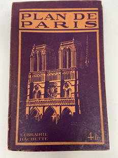
Sold2021PLAN DE PARIS Rues De Paris w/ MapLibrarie Hachette. "Liste Alphabetique Des Rues De Paris". Includes fold-out map by Imp Dufrenoy, Paris - "Grave chez Herisson Garin, 6, Rue Vercingetorix par E. Schwartz" in bottom left corner. Map mSee Sold Price
Sold2018Bellin: Antique Map of Early Boston, 1757Title/Content of Map: Plan de la Ville de Boston et ses Environs Cartographer: Bellin Place & Date: Paris / 1757/1760 Size: 10 5/8" x 6 3/8" Condition: b&w; light overall age toning; a few spots in thSee Sold Price
Sold2017Bellin: Antique Plan of Pensacola Bay in Florida, 1764Map: Plan de la Baye de Pensacola dans la Floride Cartographer: Bellin Place & Date: Paris / 1764 Size: 6 1/2" x 8 1/8" Condition: outline color; light overall age toning; a few minor spots in marginsSee Sold Price
Sold2017Dela Haye: Plan de la Baye de l'Acul (Haiti), 1787Map: Plan de la Baye de l'Acul; Baye de Dame-Marie; Le Port François; Plan du Môle St. Nicolas; Baye des Irois Cartographer: Dela Haye / Dépôt de la Marine Place & Date: Paris / 1787 Size: 17 1/2"See Sold Price
Sold2017Bellin: Plan of Malacca City/Tonkin River Basin ChartMap: Plan de la Ville et Forteresse de Malaca [and on the same sheet] Carte du Cours de la Riviere de Tunquin [Tonkin] Depuis Cacho jusqu'a la Mer Cartographer: Bellin Place & Date: Paris / 1750/1760See Sold Price
Sold2017Bellin: Antique Map of Santiago de Cuba Bay, 1764Map: Plan de la Baye St. Yago dans l'Isle de Cube Cartographer: Bellin Place & Date: Paris / 1764 Size: 6 1/4" x 8 1/4" Condition: wash color; light overall age toning, very light water stain in wideSee Sold Price
Sold2018Bellin: Plan of Kyoto, JapanMap: Plan de la Ville de Meaco [Kyoto] Cartographer: Bellin Place & Date: Paris / 1752/1760 Size: 10 3/4" x 7 1/2" Condition: b&w; light overall age toning; margins extended with contemporary paper toSee Sold Price
21 hrs LeftJeschke Jadi Auctions Berlin GmbHNouveau Plan illustré de la Ville de Paris avec le système complet de ses fortifications€300
May 14Fleischer's Auctions1755 Map Partie de l'Amerique Septentrionale, qui comprend Le Cours de L'Ohio...$200(3 bids)
5 days LeftDoyle New YorkVaugondy's map of Virginia and Maryland, a reduction of Fry and Jefferson's landmark map$600
1 day LeftTrillium Antique Prints & Rare BooksBonne - Map of the Eastern Coast of North America$85(3 bids)
21 hrs LeftJeschke Jadi Auctions Berlin GmbHRochenoire, Julien de la La Peinture à l'huile apprise seule. 2 Tle. in 1 Bd. Mit lithogr.€350
Featured4 days LeftJasper521771 ASTRONOMY by Joseph M. de La Lande 2 VOLUMES ILLUSTRATED antique in FRENCH$480
May 09Hunt and Peck Estate Services, Inc.Sanson & Jaillot "Le Royaume de Naples Divisé en Douze Provinces"$200
5 days LeftJasper521714 Chatelain Map of Moscow with Coats of Arms -- Carte du Gouvernement Civil et Ecclesiastique de$240


![Bellin: Plan of Malacca City/Tonkin River Basin Chart: Map: Plan de la Ville et Forteresse de Malaca [and on the same sheet] Carte du Cours de la Riviere de Tunquin [Tonkin] Depuis Cacho jusqu'a la Mer Cartographer: Bellin Place & Date: Paris / 1750/1760](https://p1.liveauctioneers.com/5584/105261/53910605_1_x.jpg?height=310&quality=70&version=1497542970)

![Bellin: Plan of Kyoto, Japan: Map: Plan de la Ville de Meaco [Kyoto] Cartographer: Bellin Place & Date: Paris / 1752/1760 Size: 10 3/4" x 7 1/2" Condition: b&w; light overall age toning; margins extended with contemporary paper to](https://p1.liveauctioneers.com/5584/119622/60966656_1_x.jpg?height=310&quality=70&version=1522802109)


