Sold2019East coast of Italy. Ancona coastline, gulf of VeniceTitle/Content of Map: East coast of Italy. Ancona coastline, gulf of Venice with sea monster Date: 1598/99 Cartographer: Ruscelli Size: 11x9” Provenance: Venice Additional Info: Copperplate engravedSee Sold Price
Sold20231837. Map of North Eastern Italy. Venice region and Lombardy. By A. PerrotTitle: 1837. Map of North Eastern Italy. Venice region and Lombardy. By A. Perrot Date/Period: 1837 Materials: Copperplate engraved Size: 7 x 10 3/4” This is a map of Northeastern Italy, VeniceSee Sold Price
Sold2023Baedeker, Karl 1886 Map. Venice Venezia. ItalyLithograph Map Published 1886, Leipzig for "L'Italie des Alpes a Naples" by Karl Baedeker. Folds as issued. Paper Size: 14.5 x 10 inch (37 x 25cm) Good Condition overallSee Sold Price
Sold2018NORTHERN ITALY: Sardinian/Papal States.VenetianTITLE/CONTENT OF MAP: 'Northern Italy' Vignettes: The Grand Canal - Venice; St. Peter's - Rome; Religious Procession. Shows railways. Date: 1851 IMAGE SIZE: Approx 36.5 x 26.5cm, 14.5 x 10.25 inches (See Sold Price
Sold2024Antique Map of Italy - Venice - Jodocus Hondius"Dominium venetum in Italia." Attractive and early map of the area around Venice, Italy. With South-Tirol in the North, areas of Krain (Slovenia), Croatia, Ferrara, Modena and Piacenza. In the east wiSee Sold Price
Sold2022Large detailed map of Gulf of Venice, 1693Heading: Author: Jaillot, Alexis-Hubert Title: Le Golfe De Venise, Avec ses Principaux Caps, Promontoires, & Ports de Mer Place Published: Paris Publisher: Date Published: 1793 DescripSee Sold Price
Sold20211720 c. Homann Map of Norteast Italy, Venice IncludedTitle: 1720 c. Homann Map of Norteast Italy, Venice Included -- Dominii Veneti cum vicinis Parme Mutinae Mantuae et Mirandole Statibus Cartographer: J Homann Year / Place: 1720 c., Nurnberg Map DimensSee Sold Price
Sold2023B.R.Davies Hand Colored Antique Venice Italy MapMarked on backside Authentic Antique Print, date London c.1840 Medium. Hand colored engraving, artist, B.R. Davies. Marked on lower right corner engraved by B.R.Davies, drawn by WB Clarke. Reads VenicSee Sold Price
Sold2018BALKANS.Yugoslavia Historical; Bosnia Serbia Montenegro;TITLE/CONTENT OF MAP: 'Yugo - Slavia (Historical); Insert map of Gulf of Venice' DATE PRINTED: 1920 IMAGE SIZE: Approx 21.5 x 32.5cm, 8.5 x 12.75 inches (Large) TYPE: Vintage colour map; Scale 1:4,000See Sold Price
Sold2023Antique Map Northern Italy, Alps to VeniceCarta Geograpohica e Postale del Regno Lombardo-Venteto. C. Pinchetti, Giuseppe Pezze, Milan: 1848. Italian wall map, folding as dissected on linen. Slip case. Lombardy and Veneto regions of Italy. 17See Sold Price
Sold20232-map set of N. and S. Italy from 1st ed. of Colton atlasNorthern Italy and Southern Italy along with Corsica, Sardinia and Sicily offered as a 2-map set. “Northern Italy: Lombardy & Venice, Sardinia, Tuscany, Parma, Modena, Lucca and the States of thSee Sold Price
Sold2023Gulf Map and Tourgide Service w/Logo Metal Map Display (TAC)rated 8.5, 14"x18"x3.5", metal map display has very good color and shine, display panel is clean, has wear around the perimeter, comes with 10 Gulf road maps. TAC #046567See Sold Price
Sold2017Tallis / Rapkin: Antique Map of Northern Italy, 1851Title/Content of Map: 'Northern Italy' Vignettes: The Grand Canal - Venice; St. Peter's - Rome; Religious Procession. Shows railways. Sardinian/Papal States.Venetian Lombardy Date Printed: 1851 ImageSee Sold Price
Sold2020Grp: 10 Maps of British Cities w/ 1 Map VeniceGroup of maps of British cities. Includes one map of Birmingham; two road maps for the London area: "A Map of the New Roads & c. from Westminster Bridge" and "A Plan of the intended New Road from PadiSee Sold Price
Sold2022Brand new traveler's guide in Italy. Enriched with various partial itineraries maps and 15Milan, Ferdinando Artaria, s.d [1845]. In 8th. Heads with city views, 15 topographical maps of the main cities, 10 maps of itineraries and a map of Italy at the end, slight scattered blooms, small teaSee Sold Price
Sold2016SALVIATITwo stemmed glass vessels decorated with fanciful creatures, each with gold foil inclusions, Venice, Italy; 20th c.; Unmarked; Taller: 10 1/2" x 3 1/2" dia.See Sold Price
Sold2024Janvier Map of Italy - Italian Peninsula - Corsica, Sardinia"L'Italie divisee en ses differents etats Royaumes et Republiques" A beautiful example of Le Sieur Janvier's decorative map of Italy. Janvier's map covers from the Gulf of eyon eastward to include allSee Sold Price
Sold20201801 Map of ItalyAuthor: Hall Title: 1801 Map of Italy Medium: Ink on Paper Dimensions: 10.5"X8.5" Description: Map of Ancient Italy dated 1801. Part of the Atlas of Ancient Geography by Samuel Butler. Engraved by S.See Sold Price
Sold2022Barclay & Becker C1845 Map. ItalySteel Engraved Map Published C1845, London for "A Complete and Universal English Dictionary" by the Rev. James Barclay and B. B. Woodward. Maps by F. P. Becker. Outline hand colour. Paper Size: 10.5 xSee Sold Price
Sold2019Prout, Samuel 1880 Lot of 5 Prints. Italy, Venice etcFolio Autotype Published 1880, London for "Notes by Mr. Ruskin on Samuel Prout and William Hunt" by John Ruskin. Paper Size: 12.5 x 10 inch (32 x 25cm) Good ConditionSee Sold Price
Sold2018Blackie, W. G. 1882 Lot of 10 MapsIncl Europe, North Atlantic, Denmark, Persia, Canada, Peru, Bolivia, South America, Turkey/Greece, Russia, and Italy. Lithograph Maps Published 1882 by Blackie & Son, London for "The Comprehensive AtlSee Sold Price
Sold2021Findlay, Alex C1835 Antique Map. ItalySteel Engraved Map Published C1835 by Thomas Kelly, London for "A New and Universal English Dictionary" by the Rev. James Barclay. Maps Drawn & Engraved by Alexander Findlay. Paper Size: 10.5 x 8 inchSee Sold Price
Sold2023Barclay & Milton C1810 Antique Map. ItalyCopper Engraved Map Published C1810, London for "Barclay's Universal Dictionary" by James Barclay. Original outline hand colour. Maps Engraved by W. Milton. Paper Size: 10.5 x 8.5 inch (27 x 22cm) VerSee Sold Price
Sold2023Thomson, John (Pub) 1825 Map. ItalyCopper Engraved Map Published 1825 by John Thomson, Edinburgh for "The Edinburgh School Atlas" by N. R. Hewitt. Maps Engraved by Hewitt. Original Outline Hand Colour. Rare. Paper Size: 10.5 x 8 inch (See Sold Price
May 16Freeman's | HindmanGiovanni Grubacs (Italian, 1829-1919) Two Views of Venice: St. Marc Square and the Bridge of Sighs$2,000(1 bid)
6 days LeftJasper52Central America Caribbean Gulf of Mexico chart Ports lighthouses LARGE 1918 map$45
3 days LeftCurated Gallery AuctionsDoges Palace Venice Italy Signed 19th Century Finely Painted Original Oil Painting$10(1 bid)
3 days LeftCurated Gallery AuctionsAntique Italian Impressionist Istanbul Orientalist Sunset Seascape Circle of Felix Ziem (1821-1911)$350(4 bids)
1 day LeftBucklinShore,Stephen; Elements [SIGNED - 2019 1ST EDITION & 1ST PRINTING - FINE COPY]$50(1 bid)
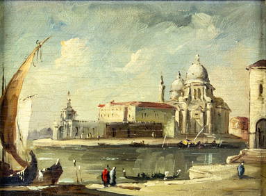
2 days LeftTremont Auctions19th/20th century Italian Guardi style Venice plaza landscape painting. Oil on canvas. Framed.$150(1 bid)
7 days LeftHunt and Peck Estate Services, Inc.ANTONIO ZATTA (ITALIAN, 18TH CENTURY) MAP OF VIRGINIA$80(2 bids)


![Brand new traveler's guide in Italy. Enriched with various partial itineraries maps and 15: Milan, Ferdinando Artaria, s.d [1845]. In 8th. Heads with city views, 15 topographical maps of the main cities, 10 maps of itineraries and a map of Italy at the end, slight scattered blooms, small tea](https://p1.liveauctioneers.com/3796/250546/130126120_1_x.jpg?height=310&quality=70&version=1654521704)


![Shore,Stephen; Elements [SIGNED - 2019 1ST EDITION & 1ST PRINTING - FINE COPY] (1 of 2)](https://p1.liveauctioneers.com/8658/325945/175541534_1_x.jpg?height=282&quality=70&version=1712964944)


