Sold20231849 1ed Boston Almanac MAP Atlas Calendar Business Directory Illustrated Schools1849 1ed Boston Almanac MAP Atlas Calendar Business Directory Illustrated Schools A rare 1849 almanac of the City of Boston, Massachusetts. This almanac, like many of its era, contains descriptions ofSee Sold Price
Sold2017New England Mercantile Union Directory 1849Heading: (New England) Author: Title: The New-England Mercantile Union Business Directory, Six Parts in One. Containing a New Map of New-England, an Almanac for 1849, a Memorandum for Every Day in thSee Sold Price
Sold20241885 Civil War 1ed Memoirs of Union General Ulysses S. Grant Illustrated MAPS 2v1885 Civil War 1ed Memoirs of Union General Ulysses S. Grant Illustrated MAPS 2v “The art of war is simple enough. Find out where your enemy is. Get at him as soon as you can. Strike him as hard asSee Sold Price
Sold2017Mitchell's 1849 New Universal AtlasHeading: Author: Mitchell, S. Augustus Title: New Universal Atlas Containing Maps of the various Empires, Kingdoms, States and Republics of the World. With a special map of each of the United States,See Sold Price
Sold2022[TATTOO]. Prof. J.S. Fraser Boston Expert Electric Tattooin...[TATTOO]. Prof. J.S. Fraser Boston Expert Electric Tattooing business card. Boston, [ca. early 20th century]. Printed cardstock, illustrated with samples of the tattooist’s work and listing an aSee Sold Price
Sold2023PORTRAIT OF JOHN APSINWALL (1774-1847)American School (19th c) oil on canvas. 45 x 36 inches (overall including custom frame). N.B. John and his brother Gilbert originally from Brookline, Boston they formed the shipping merchant businessSee Sold Price
2021Bradford's Map of Texas 1835/36"Bradford's Map of Texas, 1st Separate Map of Texas to Appear in an Atlas" by Thomas G. Bradford, copper engraving with hand-colored outlines, published Boston, 1835/1836, together with accompanying aSee Sold Price
Sold2020Cleveland or Boston School Peacock desk setCleveland or Boston School Peacock desk set: two bookends, desk calendar, rolling blotter, all with enamel United States copper, polychrome enamel unmarked bookend: 5"w x 5 15/16"d x 6 3/8"h ProvenancSee Sold Price
Sold20221772 Boston Almanac With PAUL REVERE Engravings!Colonial America 1772 Paul Revere Engraved Metal Cut Illustration Prints Including the Historic Portrait of Patriot John Dickinson (PAUL REVERE, JR.) 1772-Dated Colonial Pre-Revolutionary War Period,See Sold Price
Sold2023Sauthier & Fadden Revolutionary War Map EngravingAn original 18th Century hand colored engraved topographical map, illustrated by Claude Joseph Sauthier (1736–1802) and published by William Faden (1749-1836), the latter serving as royal geogrSee Sold Price
Sold2023[MAP]. FRY & JEFFERSON. A Map of the Most Inhabited Part of Virginia. 1775. FIRST PRINTED MAP OF[MAPS & ATLASES]. FRY, Joshua (1699-1754) and Peter JEFFERSON (1708-1757). A Map of the Most Inhabited Part of Virginia containing the whole Province of Maryland with Part of Pensilvania, New JersSee Sold Price
Sold2017World.- SDUK Atlas.- Maps of the Society for theWorld.- SDUK Atlas.- Maps of the Society for the Diffusion of Useful Knowledge, 4 parts in 1, parts 1-2 with 207 engraved maps, hand-coloured in outline, a few double-page, part 3 "Stars" with 6 hand-See Sold Price
Sold2021(19th / 20th c) BOSTON MUSEUM SCHOOL FIGURE CLASS"Seated Male Figure with Artist in the Background" oil on canvas 30 x 22 inches. signed "M" lower right. unframedSee Sold Price
Sold2021Dutch Nicolaes Visscher I Map of New Amsterdam, ca 1690Nicolaes Visscher I. Map of Northeast with Early View of New York City. Ca. 1690 to 1729. A finely hand-colored example of Nicolaes Visscher I's illustrated map of the Northeast of America with an insSee Sold Price
Sold2016American Atlas TG Bradford 1842Heading: Author: Bradford, Thomas Gamaliel and Samuel Griswold Goodrich Title: A Universal, Illustrated Atlas, exhibiting a Geographical, Statistical and Historical View of the World Place Published:See Sold Price
Sold2023Original Vintage Indochine Francaise Map by Lucien Boucher 1935 Vietnam Laos CambodiaAs one can only imagine, travel in the Far East in the 1920's must have been a challenging adventure. This well illustrated map poster by master artist, Lucien Boucher shows the various routes once coSee Sold Price
Sold2024Lot 2 Greenwich Village Guide Illustr 1959 +Lot of 2 books. Softcover copy of Greenwich Village Guide with map and directory. Published by The Chaucer Press, 1959. With some illustrations. Measures approx. 7 x 4.5 inches. Softcover copy of NewSee Sold Price
Sold2022The interior of the palace at Madura, with the District Collector conducting business Company Sch...The interior of the palace at Madura, with the District Collector conducting business Company School, Madura, South India, circa 1840 pencil and watercolour on paper, inscribed (formerly in lower bordSee Sold Price
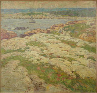
Sold2023Stevens, William Lester. View of Ten Pound Island 1921 Oil on Canvas Rockport Art AssociationDated 1921, and signed lower right. Very good, apparently restored in 1977 (see writing on back of stretcher). Stevens attended the Boston Museum School as a student of William Tarbell, Frank Benson,See Sold Price
Sold2022Simon Willard patent timepiece or banjo wall clockSimon Willard School, Boston, Mass., patent timepiece or banjo wall clock, mahogany case, painted metal dial, barbed hands, 8 day time only movement, c1808See Sold Price
Sold2021Rare set H.C. Tunison Wall MapsHeading: Author: Tunison, Henry Cuthbert Title: Tunison’s Twentieth Century Series of School Maps Place Published: Jacksonville, IL Publisher:H.C. Tunison, Publisher Date Published: c.1905See Sold Price
Sold202319th French Celestial Globe Simon Editeur DelagraveThe publisher was Charles Delagrave (1842-1934), an educational publisher with a specialization in maps and atlases. M. Ch. Simon was the director of " l'Observatoire de Marseille ,an astronomical obsSee Sold Price
Sold20241598 COSMOGRAPHY by Sebastian Munster antique RARE ILLUSTRATED w/ MAPS PIGSKINMUNSTER, Sebastian (1489-1552). Cosmographey, das ist, Beschreibung aller Länder, Herrschafften und fürnemesten Stetten des gantzen Erdbodens Cosmography: that is, description of all countries... BaSee Sold Price
Sold2022MAPS IN BOOK, Atlases, CareyCarey's Famous 1814 General Atlas. Atlases. Mathew Carey, Carey's General Atlas, Improved and Enlarged: Being a Collection of Maps of the World and Quarters, Their Principal Empires, Kingdoms, &c., 18See Sold Price
May 12Schilb Antiquarian Rare Books1869 ATLAS 42 MAPS America Africa Australia GERMANY Switzerland Sydow RARE$130(3 bids)
May 11Cape Ann AuctionBatch of 1880s-1910s Antique Railroad Ephemera from Estate of Railroad Conductor$50
May 15University ArchivesPaul Revere Engraving in 1766 Publication "An Astronomical Diary or Almanack"$500
May 14Fleischer's Auctions1755 Map Partie de l'Amerique Septentrionale, qui comprend Le Cours de L'Ohio...$200(3 bids)
May 12Schilb Antiquarian Rare Books1867 1ed Tennyson Elaine King Arthur Lancelot Guinevere Idylls of King DORE Art$52(4 bids)
Bonhams[OCCULT SCIENCE] 'THE MAGICAL CALENDAR OF TYCHO BRAHE': RARE HERMETIC BROADSIDE. GROSSCHEDEL, JO...$22,000


![[TATTOO]. Prof. J.S. Fraser Boston Expert Electric Tattooin...: [TATTOO]. Prof. J.S. Fraser Boston Expert Electric Tattooing business card. Boston, [ca. early 20th century]. Printed cardstock, illustrated with samples of the tattooist’s work and listing an a](https://p1.liveauctioneers.com/928/259477/135055399_1_x.jpg?height=310&quality=70&version=1661545183)


![[MAP]. FRY & JEFFERSON. A Map of the Most Inhabited Part of Virginia. 1775. FIRST PRINTED MAP OF: [MAPS & ATLASES]. FRY, Joshua (1699-1754) and Peter JEFFERSON (1708-1757). A Map of the Most Inhabited Part of Virginia containing the whole Province of Maryland with Part of Pensilvania, New Jers](https://p1.liveauctioneers.com/197/305583/163286504_1_x.jpg?height=310&quality=70&version=1697143109)


![[WWI] P.T. Sherman's WWI Service Record & Books (1 of 8)](https://p1.liveauctioneers.com/7226/322253/173251586_1_x.jpg?height=282&quality=70&version=1710004847)


![[OCCULT SCIENCE] 'THE MAGICAL CALENDAR OF TYCHO BRAHE': RARE HERMETIC BROADSIDE. GROSSCHEDEL, JO... (1 of 4)](https://p1.liveauctioneers.com/1043/325155/176458568_1_x.jpg?height=282&quality=70&version=1714118631)
