Sold2018AN 1659 FRENCH MAP OF DENMARK BY NICOLAS SANSONA hand-colored map of Northern Denmark by Nicolas Sanson (1600-1667), signed Sanson and dated with a cartouche on the lower left. Sheet measures 16.25 x 21 inches. Frame measures 20.5 x 26.5 inches. WSee Sold Price
Sold2018AFTER NICOLAS SANSON (FRENCH, 1600-1667) MAP OF NORTHAFTER NICOLAS SANSON (FRENCH, 1600-1667) MAP OF NORTH AMERICA, hand-colored, on laid paper, title in cartouche to upper left corner lettered "NORTH AMERICA / Divided into it's Principall Parts / whereSee Sold Price
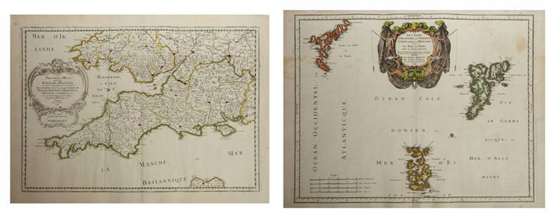
Sold2023AFTER NICOLAS SANSON (FRENCH, 1600-1667) MAP OF CALIFORNIA AS AN ISLANDAFTER NICOLAS SANSON (FRENCH, 1600-1667) MAP OF CALIFORNIA AS AN ISLAND, hand-colored engraving on laid paper, titled "AUDIENCE DE / GUADALAJARA / NOUVEAU MEXIQUE / CALIFORNIE, &c. / Par N. SSee Sold Price
Sold2023AFTER NICOLAS SANSON (FRENCH, 1600-1667) MAP OF FLORIDAAFTER NICOLAS SANSON (FRENCH, 1600-1667) MAP OF FLORIDA, hand-colored engraving on laid paper, titled "FLORIDA / zoo als het van de / SPAANSCHEN en FRANSCHEN / wordt bezeten. / door N. Sanson. /See Sold Price
Sold2023AFTER NICOLAS SANSON (FRENCH, 1600-1667) MAP OF CANADAAFTER NICOLAS SANSON (FRENCH, 1600-1667) MAP OF CANADA, hand-colored engraving on laid paper, titled "CANADA / of / NIEW VRANKRYK / Getrokken uit verfscheide Franfche, / Engelfche, en HollanSee Sold Price
Sold2023AFTER NICOLAS SANSON (FRENCH, 1600-1667) MAP OF GREAT BRITAINAFTER NICOLAS SANSON (FRENCH, 1600-1667) MAP OF GREAT BRITAIN, hand-colored engraving on laid paper, engraving by Robert De Vaugondy. Unframed. Circa 1750. 21 3/4" x 31". Provenance: BSee Sold Price
Sold2018Small 1735 French map with California as an Island andTitle: Amerique Septentrionale par N. Sanson d'Abbeville Geographe du Roy Map maker: Nicolas Sanson, Introduction a l'histoire de l'Asie, de l'Afrique et de l'Amerique... par Mr. Bruzen la MartiniereSee Sold Price
Sold2020Group of French Maps Guillaume de l'Isle SansonGroup of four 17th and 18th century French maps. Guillaume Delisle (1675-1726) hand colored engraved map of Picardie, 1748. Two maps by Nicolas Sanson (1600-1677), "Le Roayaume de France" and "GouvernSee Sold Price
Sold2022Alexis Hubert Jaillot and Nicolas Sanson - Map of the Grand Duchy of Moscow, Etching, 1708.Alexis Hubert Jaillot (French, 1632-1712) and Nicolas Sanson (French, 1600-1667) - Map of the White Russia or the Grand Duchy of Moscow, Etching, 1708. Title: Les Estats du Czaar de Russie Blanche ouSee Sold Price
Sold2022French Le Maine hand colored map engraving, central France, by Nicolas Sanson (1600-1667) 15"H xFrench Le Maine hand colored map engraving, central France, by Nicolas Sanson (1600-1667) 15"H x 19"W (image), 23"H x 30 3/4"W (frame)See Sold Price
Sold2021Antique French Regional MapLa Lorraine qui Comprend les Duches de Lorraine et de Bar. Nicolas Sanson -- Charles Hubert Jaillot, Paris, 1700. Engraving, uncolored.. 21" x 28".See Sold Price
Sold2017Nicolas Sanson, 17th c. map of Imperial RomeNicolas Sanson, 17th c. map of Imperial Rome, Nicolas Sanson (French, 1600-1667), "Imperii Romani geographica descriptio ad Herodiani historiam", c. 1650, Roman territory throughout Europe and Asia asSee Sold Price
Sold2024Map. Portugal. Nicolas SansonPortugal. Nicolas Sanson Hand Colored Map Paris. 1654 17" x 23".See Sold Price
Sold2019Three Maps by Nicolas Sanson (1600-1667, Paris), Two-Three Maps by Nicolas Sanson (1600-1667, Paris), Two- "Carte Generalle d'Espagne .. Royaumes," 1641; together with "Gouvernement General d'Orteans Maine, le Perche, la Beauce..Gastinois," 1650, hand cSee Sold Price
Sold2019Two Maps by Nicolas Sanson (1600-1667, Paris), "Isle deTwo Maps by Nicolas Sanson (1600-1667, Paris), "Isle de France, Champagne, Lorraine," 1679; together with "Le Royaume de France, Toutes ses Provinces, et ses Acquisitions, L'Espagne le Luxembourg," 16See Sold Price
Sold2019Three Maps by Nicolas Sanson (1600-1667, Paris),Three Maps by Nicolas Sanson (1600-1667, Paris), "Lespagne en Plusieurs Peuples suiant Peolomee," 1641; together with two- "Galliae Antiquae Descriptio Geographica," 1629 Geographica- H. - 17 in., W.See Sold Price
Sold2019Two Maps by Nicolas Sanson (1600-1667, Paris), " LaTwo Maps by Nicolas Sanson (1600-1667, Paris), " La France L'Ancienne Gaule Primatiats… ar Evesches et Evesches," 1679; together with "Le Royaume de France et es Acqusitions Pays Bas L'AllemagneSee Sold Price
Sold2019Group of Three Maps by Nicolas Sanson (1600-1667,Group of Three Maps by Nicolas Sanson (1600-1667, Paris), "La Gaule en dixsept provinces Romain," 1641; together with "Gouvernment General du Lyonnois, Forez, Beavoilais," 1679; and "Gouvernment De FrSee Sold Price
Sold2019Two Maps by Nicolas Sanson (1600-1667, Paris),Two Maps by Nicolas Sanson (1600-1667, Paris), "Provinces d'West Royame d'Westsex," 1679; together with"Les Isles Orcadney, ou Orkney Farre," 1665, Orcadney- H. - 16 in., W. - 23 in., d'Westsex- H. -See Sold Price
Sold2019Two Maps by Nicolas Sanson (1600-1667, Paris), "LeCoursTwo Maps by Nicolas Sanson (1600-1667, Paris), "LeCours de la Riviere du Rhein. Tous LeDauphin les Estats et Souverainetes," 1692; together with "Gallia Vetus ex C.lulii C aefaris comentarii descripaeSee Sold Price
Sold2019Two Maps by Nicolas Sanson (1600-1667, Paris)," AncientTwo Maps by Nicolas Sanson (1600-1667, Paris)," Ancient Royaume de Northumbland and Provinces de Nort," 1679; together with " L'Escosse de la Tay… Provinces… Stralloch," 1665, Stralloch- HSee Sold Price
Sold2019Two Maps by Nicolas Sanson (1600-1667, Paris),Two Maps by Nicolas Sanson (1600-1667, Paris), "L'Estats de'Englise et de Toscane," 1648, together with "Nicens Ory de Mercie," 1654 H. - 17 in., W. - 23 in. (2 Pcs.)See Sold Price
Sold2019Two Maps by Nicolas Sanson (1600-1667, Paris),Two Maps by Nicolas Sanson (1600-1667, Paris), "Principaute de Galles, Nort Walles," 1679; together with "Hispaniae Antiqua Tabulae," 1641, hand colored, Tabulae- H. - 16 in., W. - 23 in., Galles- H.See Sold Price
Sold2019Two Maps by Nicolas Sanson (1600-1667, Paris), "LaTwo Maps by Nicolas Sanson (1600-1667, Paris), "La Judee ou Palestine Herodes," together with "Gouvernement General de L'lsle de France et Pays Circomvoisins," 1679, France- H. - 15 in., W. - 20 in.,See Sold Price
5 days LeftHunt and Peck Estate Services, Inc.Jacques Nicolas Bellin Map Of Western Part Of New France Or Canada$200(1 bid)
7 days LeftTrillium Antique Prints & Rare BooksBonne - Pair of Maps (Eastern & Northern Hemisphere)$75
May 12Schilb Antiquarian Rare Books1844 Siege of Gibraltar American Revolution SPAIN France Drinkwater MAP History$1(1 bid)
3 days LeftWilliam Bunch Auctions & AppraisalsEuropean, likely French or Danish, late 19th C, hall clock$200
May 16Potter & Potter AuctionsAUDIBERTI, J. Choain. Afrique Equatoriale Francaise. Paris:...$100(1 bid)
May 18Selkirk Auctioneers & AppraisersCRESCO MODULAR WALL SYSTEM BY FINN JUHL FOR FRANCE AND SONS$1,000
3 days LeftJasper521753 Robert de Vaugondy Map of Central France -- Gouvernemens Generaux De La Marche, Du Limosin Et$45
May 19Rich Penn AuctionsMilitaria Miniature Dress Orders/Medals (5), Royal Victorian, Prussian Crown, 1911 Coronation,$50(1 bid)