Sold2018Blaeu Map of Europe -- Europa Recens DescriptaTitle/Content of Map: Blaeu Map of Europe -- Europa Recens Descripta Date: 1635, Amsterdam Cartographer: W Blaeau Size: 16.1 X 21.9 in. This is a grand, large, classic map of Europe, produced at the gSee Sold Price
Sold2021WILLEM BLAEU Map of Europe Offset LithographWILLEM BLAEU Map of Europe Offset Lithograph, inscriptions to piece in Latin, a map of Europe with representations of its people to border, measures 20 5/8 x 24 5/8 inches, wooden frame, surface wearSee Sold Price
Sold2018Blaeu: Antique Map of Europe, 1650Title/Content of Map: Highly decorative Map by Blaeu Date Printed: c1650 Cartographer: W. Blaeu Material/Medium: Paper Size: 19" x 24" Hand colored engraved Map. French text on Verso. Magnificent examSee Sold Price
Sold2017Blaeu map of Cyprus c.1640Heading: Author: Blaeu, Willem Title: Cyprus Insula Place Published: Amsterdam Publisher: Date Published: c.1640 Description: Copper-engraved map, hand-colored in outline,See Sold Price
Sold2024Vintage William Blaeu Colored Map of EuropeVintage William Blaeu Colored Print Map of Europe, Framed. Measures 28 inches x 23 inches.See Sold Price
Sold2018Tallis/Rapkin: Antique Map of Turkey in Europe, 1851TITLE/CONTENT OF MAP: 'Turkey in Europe' Vignettes: The Bosphorus and Constantinople; Ali Pasha; Greek Caloyer. The Balkans: Rumilia, Macedonia, Albania, Wallachia, Moldavia, Bulgaria, Servia, Bosnia,See Sold Price
Sold2017Tallis/Rapkin: Map of Europe, Slave Market, 1851Title/Content of Map: EUROPE: Austrian Empire Prussia Poland. Slave market. Vignettes: Seal hunting; Lapland Travellers; Russian Travellers; Ships; Arab and camel; Slave Market DATE PRINTED: 1851 IMAGSee Sold Price
Sold2021Eleven Antique Maps of EuropeEleven Antique Maps of Europe , 16th-18th c., incl. Ptolemy from 1541 (4); a Blaeu map of "Regno di Napoli", Hondius map of the Holy Land, de Wit map of Southern Spain, an undated manuscript map of MeSee Sold Price
Sold2019Blaeu map of western Holland.Heading: Author: Blaeu, Willem Title: Hollandia Comitatus Place Published: Amsterdam Publisher: Date Published: c.1640 Description: Copper-engraved map, hand-colored. 39x52See Sold Price
Sold2024TURKEY IN EUROPE. Constantinople view. Rumilia Balkans. TALLIS & RAPKIN 1851 mapCAPTION PRINTED BELOW PICTURE: 'Turkey in Europe' Vignettes: The Bosphorus and Constantinople; Ali Pasha; Greek Caloyer. The Balkans: Rumilia, Macedonia, Albania, Wallachia, Moldavia, Bulgaria, ServiaSee Sold Price
Sold2021Pinnock & Archer 1833 Map. EuropeWoodblock Published 1833, London for "The Guide to Knowledge" Edited by W. Pinnock. Maps by Joshua Archer. Reverse side blank. Paper Size: 10.5 x 7.5 inch (27 x 19cm) Good ConditionSee Sold Price
Sold2021Thomson, John (Pub) 1825 Map. EuropeCopper Engraved Map Published 1825 by John Thomson, Edinburgh for "The Edinburgh School Atlas" by N. R. Hewitt. Maps Engraved by Hewitt. Engraved Vignette in corner. Original Outline Hand Colour. RareSee Sold Price
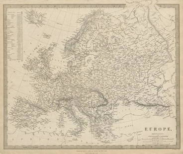
Sold2019EUROPE. General map. Inset table of population &TITLE/CONTENT OF MAP: 'EUROPE; inset table of population by country' The top image on the right hand side shows the entire map. To view a close up of the map showing the level of printed detail, pleasSee Sold Price
Sold2019Two Primitive Paint Decorated YaYa Side Chairs, 20thTwo Primitive Paint Decorated YaYa Side Chairs, 20th c., New Orleans, one with a map of Europe; the second with an angel and tinkerbell, Angel- H.- 46 1/2 in., W.- 18 in., D.- 21 in.See Sold Price
2017Tallis: Antique Map of Europe, 1851Map: 1851 Tallis Map of Europe -- Europe Cartographer: J Tallis Year / Place: 1851, London Map Dimensions: 9.5 x 12.5 in. Condition: Very good. Nice strike and nice hand color of vignettes and outlineSee Sold Price
Sold2017Tallis: Antique Map of Europe, 1851Map: 1851 Tallis Map of Europe -- Europe Cartographer: J Tallis Year / Place: 1851, London Dimensions: 9.5 x 12.5 in. Condition: Very good. Nice strike and nice hand color of vignettes and outline hanSee Sold Price
Sold2019GERMANY general Map. Central Europe. Hungary.TITLE/CONTENT OF MAP: 'GERMANY, General map' The top image on the right hand side shows the entire map. To view a close up of the map showing the level of printed detail, please click on the bottom imSee Sold Price
Sold2017Mitchell: Antique Map of Europe, 1864Title: Map of Europe by Mitchell Date: 1864 Dimensions (inches): 15.5 x 12.5 Medium: Hand Colored Lithograph Condition: Slight rip on left side Samuel Augustus Mitchell (1790-1860) was an American geoSee Sold Price
Sold2018Blaeu: Landmark Map of the AmericasCartographer: Willem Blaeu Place/Date: Amsterdam / 1617/1665 Size: 21 1/2" x 16 1/2" Condition: contemporary color; minor spotting, a few small printer's creases at sides of image. Some waterstainingSee Sold Price
Sold2024Prewar Antique Silk Double Sided Map of Europe Germany France Belgium HollandPrewar Antique Silk Double Sided Map of Europe Germany France Belgium Holland. Measurements in inches: 29 x 28 1/2 Condition:Has browning along one edge on both sides of map Shipping:We offer in-houseSee Sold Price
Sold2018TURKEY IN EUROPE: Constantinople (Istanbul) vignette.TITLE/CONTENT OF MAP: 'Turkey in Europe' Date: 1860 IMAGE SIZE: Approx 27.0 x 33.5cm, 10.5 x 13.25 inches (Large); Please note that this is a folding map. TYPE: Antique steel engraved map with originaSee Sold Price
Sold2021Thomson, John (Pub) 1825 Map. Russia in EuropeCopper Engraved Map Published 1825 by John Thomson, Edinburgh for "The Edinburgh School Atlas" by N. R. Hewitt. Maps Engraved by Hewitt. Engraved Vignette in corner. Original Outline Hand Colour. RareSee Sold Price
Sold2019RUSSIA IN EUROPE. Oblasts.Ukraine Baltics FinlandTITLE/CONTENT OF MAP: 'Russia in Europe' The map shows European Russia west of the "Ouralian" (Ural) mountains, including Finland and Transcaucasia. Vignettes: Polish Captives on their way to Siberia;See Sold Price
Sold2022Ratzel, Friedrich 1898 Lot of 5 Ethnographic MapsIncl Oceania/Australia, Africa, America, Asia/Europe. Lithograph Maps Published 1896-98, London for "The History of Mankind" by Professor Friedrich Ratzel. Translated by A. J. Butler. Reverse side blaSee Sold Price
May 09Hunt and Peck Estate Services, Inc.1784 Captain James Cook "A Voyage to the Pacific Ocean" 2 of 3 volumes$200(1 bid)
May 05Tremont Auctions17th century "Sub Polo Artico" original map by Blaeu. 2 sided framing. Overall: 18.375 x 22.5in.$150(1 bid)
May 05Tremont Auctions17th century Brazil original map. "Prefecturae Paranburae Pars Borealis" map by Blaeu. Sheet size:$200(1 bid)
7 days LeftBucklinVarious; Orienetation for the Pacific Theater [RARE 1945 US WAR DEPARTMENT PAMPHLET WWII PROPAGANDA]$50(1 bid)
May 09Hunt and Peck Estate Services, Inc.Abraham Ortelius Map Middle East "Turcici Imperii Descriptio"$240(1 bid)
May 09Hunt and Peck Estate Services, Inc.Abraham Ortelius Map Middle East "Turcici Imperii Descriptio"$140
May 16Potter & Potter AuctionsArmour’s Food Source Map / The Greatness of the United Stat...$200
May 09Rail & Road Auctions1951 Chicago, Milwaukee, St. Paul & Pacific Railroad Wall Map - Route of the Hiawathas$50
7 days LeftTrillium Antique Prints & Rare BooksBlaeu?s Le Theatre du Monde? ? Volume 3 with 57 Fold Out Maps with Original Hand-coloring, 4 Smaller$1,000(1 bid)


![Various; Orienetation for the Pacific Theater [RARE 1945 US WAR DEPARTMENT PAMPHLET WWII PROPAGANDA] (1 of 4)](https://p1.liveauctioneers.com/8658/325945/175540885_1_x.jpg?height=282&quality=70&version=1712964944)


