Sold2024Claes Visscher Reproduction 1618 Map of ParisClaes Janszoon Visscher II reproduction map of the city of Paris, Lutetia Parisorum urbs, toto orbe celeberrima notissimaque, caput regni Franciae, 1618. 24 1/4" x 35 1/4" (with frame 27 1/4" x 38 3/8See Sold Price
Sold2023After Claes Jansz Visscher, Map of ParisAfter Claes Jansz Visscher (Dutch, 1586-1652), engraving on paper depicting a 1618 map of Paris, flanked on either side by illustrations of Parisian citizens from the King and Queen, to the common vilSee Sold Price
Sold2018VINTAGE REPRODUCTION 18TH C. MAP OF PARISDimensions: (Frame) H 33" x W 44.75", (Sight) H 29" x W 40.5" Condition: Slight discoloration and buckling to paper. Some light wear to frame.See Sold Price
Sold2024Six Maps including Visscher's Map of America[SIX MAPS] 1. VISSCHER, Nicolas (1618-1679). Novissima et Accuratissima Totius Americae descriptio. Engraved map with original hand color. Amsterdam, c. 1677. 20" x 24" visible, 29 1/2" x 33 1/2" framSee Sold Price
Sold2019Nicolao Visscher. Orbis Terrum Nova MapNicolao Visscher (Dutch, 1618-1709). A hand-colored engraved map, circa 1658. Orbis Terrum Nova et Accuratussna Tabula. Showing partial coastlines of New Zealand and Australia. Unframed. 23-1/2 in x 2See Sold Price
Sold2023After Michel Etienne Turgot, map of ParisAfter Michel Etienne Turgot, map of Paris, Fine quality reproduction of one of the 20 plates from the Turgot 1739 Plan of Paris, blind-stamp of the Musee de Louvre center lower margin, framed under glSee Sold Price
Sold2019Two Framed Maps: Paris by J. Shury & HavanaA framed reproduction of an 1853 map of Havana [Framed dimensions: 17 1/4 x 21 3/4 inches], and a framed antique map of Paris, engraved by J. Shury. [Framed dimensions: 16 3/8 x 22 1/8 inches]. In gooSee Sold Price
Sold2023Visscher Map of South East AsiaVISSCHER, Nicolas (1618-1679). Indiae Orientalis, nec non Insularum Adiacentium Nova Descriptio. Engraved map with great original hand color in full. Amsterdam, c. 1698. 20 1/2" x 24 1/8" sheet. ThisSee Sold Price
Sold2020Map, Nicolas VisscherNicolas Visscher (Dutch, 1618-1709), "Insulae Americanae in Oceano Septentrionali ac Regiones Adjacentes," circa 1682, hand-colored engraving, sight (image): 18.25"h x 22"w, overall (with frame): 27.2See Sold Price
Sold202417TH C. ANTIQUE MAP SIEGE OF LA ROCHELLE, FRANCE, FRAMED"Seige et Reddition de La Rochelle, Octobre 1628", handcolored engraving on wove paper, Claes Jansz. Visscher (II), (workshop of), Germany, 1627 - 1629. In gilt molded frame, matted under UV non-glareSee Sold Price
Sold2020Map, Nicolaes VisscherNicolaes Visscher (Dutch, 1618-1709), "Exactissima Platinatus Rheni ac Ducatus Bipontini Tabula," circa 1688, hand colored engraving, image (sight): 18"h x 22.25"w, overall (with frame): 25.25"h x 29.See Sold Price
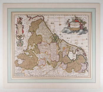
Sold2020Visscher, Claes .Germaniæ Inferioris XVIIVisscher, Claes .Germanie Inferioris XVII Provinciarum. Fine hand colored engraved double-page map. 18-1/2 x 22-1/2 inches plus margins, blank on verso, neatly matted; some browning, generally sound.See Sold Price
Sold2024Framed Vintage Style Visscher Commander Repro Map"Among the many great Dutch map publishers active in the seventeenth century were the Visscher family, begun by Claes Jansz Visscher (1587-1652) and continued by his son Nicolaas (Piscator jun. 16See Sold Price
Sold2016Nicolaes Visscher I (Dutch, 1618-1679) LeodiensisNicolaes Visscher I (Dutch, 1618-1679) Leodiensis Episcopatus. Hand-colored engraved map, 1677, together with two topographical prints: hand-colored etchings Sight: 18" x 22.75" Frame: 23" x 26.5"See Sold Price
Sold2021(5) ORBUS TERRARUM AFTER NICOLAO VISSCHERDecorative reproduction Old style maps of various regions of the world. Dimensions: (Frame) H 18.5" x W 21.5" (Sight) H 14" x W 16.25" Condition: One map missing the glass for frame. Some wear to framSee Sold Price
Sold2022Early 18th cent Holy Land Map of JerusalemVisscher, after Nicolaum (Nicolaes) (Dutch, 1618-1679), Die Heylige und Weitberuhmte Stadt Jerusalem Erstlich Genant Salem, antique map, c. 1710s, published in a German bible by Johann Detleffsen, a sSee Sold Price
Sold2023Collection of David Birney: Two Antique Mapseach: etching; the first: "Ireland from the Best Authorities", frame: 13 1/2 x 14 in. (34.3 x 35.6 cm.); the second: "Lutetia vulgo Paris Anno 1575" (reproduction), frame 18 x 24 in. (45.7 x 61 cm.);See Sold Price
Sold2017Sartine Map of FloridaCarte Réduite des Cotes et de l’Interieur de la Presqu’ile de la Floride. Antoine Sartine (1729-1801).Engraved map. Paris, 1780. 24 x 17 inches visible, 37 x 29 inches framed. This well engravedSee Sold Price
Sold2018Paris, extremely sought after renaissance view.Reserve Reduced! Title/Content of Map: Paris, extremely sought after renaissance view. Date: 1572-1617 Size: 21x16 1/2” by Braun & Hogenberg from the Civitates Orbis Terrarum, Cologne, hand colored.See Sold Price
Sold2022Michel Etienne Turgot (1690-1751): Map of Paris, engraved on paper and mounted on wooden frames, ca.Full title: Michel Etienne Turgot (1690-1751): Map of Paris, engraved on paper and mounted on wooden frames, ca. 1739 Description: 320 x 250 cm The twenty plates comprise a large and magnificent detaiSee Sold Price
Sold2021Dutch Nicolaes Visscher I Map of New Amsterdam, ca 1690Nicolaes Visscher I. Map of Northeast with Early View of New York City. Ca. 1690 to 1729. A finely hand-colored example of Nicolaes Visscher I's illustrated map of the Northeast of America with an insSee Sold Price
Sold2024Joseph Pinchon (manner), hand-painted Paris mapJoseph Pinchon (manner), hand-painted Paris map, Manner of Joseph Porphyre Pinchon (French, 1871-1953), Bird's eye view of the 2nd and 8th Arrondissements, watercolor on paper, no signature detected,See Sold Price
Sold2022Map of Paris, 16th century, FramedBraun and Hogenberg, "Lutetia, vulgari nomine Paris," from CIVITATES ORBIS TERRARUM (Cologne: G. von Kempen, first published 1572, then through several editions over 50 years); engraving with hand colSee Sold Price
Sold2020G. Braun & F. Hogenberg: MAP OF PARIS, 1575Bird’s-eye view of the city of Paris and surrounding countryside; Title in cartouche: "LUTETIA vulgari nomine Paris, urbs Galliae maxima" From Braun and Hogenberg’s atlas “Civitates Orbis TerrarSee Sold Price
2 days LeftConestoga Auction Company Division of Hess Auction GroupQuality Reproduction Plaster of Paris Belsnickel.$50
12 hrs LeftDoyle New YorkA highly detailed map of New England after the Jansson-Visscher series$250(2 bids)
May 14Fleischer's Auctions1755 Map Partie de l'Amerique Septentrionale, qui comprend Le Cours de L'Ohio...$200(3 bids)
12 hrs LeftDoyle New YorkVaugondy's map of Virginia and Maryland, a reduction of Fry and Jefferson's landmark map$600
May 16Potter & Potter AuctionsAUDIBERTI, J. Choain. Afrique Equatoriale Francaise. Paris:...$100(1 bid)
14 hrs LeftJasper52Oil painting Reproduction of the painting by Eduard Leon Cortes "Streets of Paris" Dmytro Butko$70
May 16Potter & Potter AuctionsBOUCHER, Lucien (1889 – 1971). Provence Breguet 763 / Air F...$300


![Six Maps including Visscher's Map of America: [SIX MAPS] 1. VISSCHER, Nicolas (1618-1679). Novissima et Accuratissima Totius Americae descriptio. Engraved map with original hand color. Amsterdam, c. 1677. 20" x 24" visible, 29 1/2" x 33 1/2" fram](https://p1.liveauctioneers.com/1968/314554/168606424_1_x.jpg?height=310&quality=70&version=1704142666)


![Two Framed Maps: Paris by J. Shury & Havana: A framed reproduction of an 1853 map of Havana [Framed dimensions: 17 1/4 x 21 3/4 inches], and a framed antique map of Paris, engraved by J. Shury. [Framed dimensions: 16 3/8 x 22 1/8 inches]. In goo](https://p1.liveauctioneers.com/1221/144060/73206131_1_x.jpg?height=310&quality=70&version=1562178741)