Sold2020Hand Colored Map Of ItalyHand colored map of Italy, Robert circa 1770, 13" x 14" unframed, 20" x 21" framed. Provenance: John's Island, Vero Beach, Florida.See Sold Price
Sold20231855 Colton Handcolored Map, Southern Italy Kingdom of NaplesSouthern Italy Kingdom of Naples Sardinia & Malta, dated 1855, beautifully engraved, pastel colored map of Southern Italy &identifies various cities, towns, rivers, rapids, mountain passes, and an assSee Sold Price
Sold2023FRAMED CIRCA 1750 HANDCOLORED MAP OF ITALY: L'ITALIE, VAUGONDY DIDIER ROBERT, Circa 1750. - FramedFRAMED CIRCA 1750 HANDCOLORED MAP OF ITALY: L'ITALIE, VAUGONDY DIDIER ROBERT, Circa 1750. Handcolored, of the period, Vaugondy Didier Robert map of Italy. Framed in wooden moulding with green mat. SigSee Sold Price
Sold2021Large Hand Colored Framed Map of Italy, StanfordsLarge Hand Colored Framed Map of Italy, Stanfords. Dated 1859. Sight size: 4'8"h x 47-1/2"w Overall: 5'4"h x 4'7"w. Item cannot be unframed as it consists of multiple hand colored maps completing theSee Sold Price
Sold2024TWO ANTIQUE HAND COLORED MAPS OF REGIONS OF ITALYTwo antique hand colored maps of different regions of Italy. The first map is of Perugia / Perusini Italy, frame 17" x 21.5" wide, published by Abraham Ortelius after a map by Egnatio Dante. The seconSee Sold Price
Sold2021Paolo Petrini (17C.) Hand Colored Naples Italy Map17th to 18th Century panorama map by Paolo Petrini depicting the coastal region of Naples, Italy. Beautifully detailed and colored, with all divisions of the city gorgeous etching artwork throughout.See Sold Price
Sold202019th CENTURY WILLIAM BLAEU "ITALY" ENGRAVING19th CENTURY WILLIAM BLAEU "ITALY" MAP HAND COLORED COPPER PLATE ENGRAVING. Height: 27 in. by Width: 31 in.See Sold Price
Sold2023B.R.Davies Hand Colored Antique Venice Italy MapMarked on backside Authentic Antique Print, date London c.1840 Medium. Hand colored engraving, artist, B.R. Davies. Marked on lower right corner engraved by B.R.Davies, drawn by WB Clarke. Reads VenicSee Sold Price
Sold2024Antique Hand-colored Harbour Plan - Map Milazzo - Sicily, Italy, MediterraneanOriginal hand-colored copper engraving print originates from "Recueil des Principaux Plans des Ports et Rades de la Mer Méditerranée …", translated from French as "CollectionSee Sold Price
Sold2022(ITALY.) Gerard Mercator. Italia.(ITALY.) Gerard Mercator. Italia. Hand-colored double-page engraved map of Italy. 15½x19¼ inches sheet size, ample margins, French text on verso; center fold reinforced on verso, Duisberg, 1See Sold Price
Sold2021Early Hand-Colored Map of VeniceItaly, ca. 16th-17th century. Fine hand-colored engraved map of "Venetia" with boats in harbor and compass rose. Handsomely framed. MEASUREMENTS Sight wide: 5 7/8 / 15 cm. Sight height: 4 1/2 / 11.5 cSee Sold Price
Sold2017Antique 1839 Old Italy Toscana Monte Cristo Old HandAntique 1839 Old Italy Toscana Monte Cristo Old Hand Colored Map Carta Geometrica Approximately 19 1/4" x 15 1/2".See Sold Price
Sold2021Antique Map of Tuscany (Florence), ItalyAntique Map of Tuscany (Florence), Italy. Dominio Fiorentino-Blaeu-1646(after). Antique hand colored map of Tuscany; 15.5in. X 19.5in.(image size)See Sold Price
Sold2022Antique Map Print - Italy - Empire Greece - EuropeSet of 4 Map Prints. Hand-colored map print of the edition of 1851 from the work Universal Historical and Geographical Atlas ("Atlas Universel Historique et Geographique"). This iconic map contains diSee Sold Price
Sold2022Antique Map Print - Italy - Greece - Europe - SpainSet of 4 Map Prints. Hand-colored map print of the edition of 1851 from the work Universal Historical and Geographical Atlas ("Atlas Universel Historique et Geographique"). This iconic map contains diSee Sold Price
Sold2022Antique Map Print - Empire Italy - EuropeSet of 4 Map Prints. Hand-colored map print of the edition of 1851 from the work Universal Historical and Geographical Atlas ("Atlas Universel Historique et Geographique"). This iconic map contains diSee Sold Price
Sold20222 E. Bowen Maps of Italy & GreeceEmanuel Bowen, Welsh, 1694-1767. Two 18th century hand-colored engraved maps. Includes one titled "Middle or Proper Italy" and another titled "A Map of Great Greece and the Islands of Sardinia and CorSee Sold Price
Sold2018Weigel: Antique Map of Italy, 1720Title/Content of Map: Italy by Weigel Date Printed: c1720 Cartographer: C. Weigel Material/Medium: Paper Size: 14" x 17 1/2" Hand colored copperplate engraved. Published in Nuremberg. Please note thatSee Sold Price
Sold20241839 Italy Map by MoninTitle: 1839 Italy Map by Monin Date/Period: 1839 Materials: Hand colored, engraved Size: 17 1/2” x 12 1/2” 1839. By V. Monin. Paris. Hand-colored, engraved. Good condition, with some foxinSee Sold Price
Sold2020Maps 19th-20th Cent. Mixed Lot of 10 Large MapsIncl 3 Maps of Italy from the Times Atlas (1895) Map of Cuba by Estevanez (C1910) Large Hand Colored Map of Historical France by Andriveau-Goujon (C1850) Plus 5 Large 20th Century Maps, incl Port de DSee Sold Price
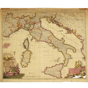
Sold2022Nicolas Sansom, map of Italy, 1701Nicolas Sansom, map of Italy, 1701, "L'Italie Divisee Suivant l'Estendue de Toutes ses Sourverainetes…", Pieter Schenk, Amsterdam, 1701, hand-colored copper plate engraving on laid paper, 20.25"See Sold Price
Sold2021Nicolas Sansom, map of Italy, 1701Nicolas Sansom, map of Italy, 1701, "L'Italie Divisee Suivant l'Estendue de Toutes ses Sourverainetes…", Pieter Schenk, Amsterdam, 1701, hand-colored copper plate engraving on laid paper, 20.25"See Sold Price
Sold201819th Map of ItalyHand colored. With Greek key border. In an elaborate frame. With Lorin Marsh, NYC S: 39 inches height, 49.5 inches width F: 53 inches height, 65 inches width S: 39"H x 49.5"WSee Sold Price
Sold201818TH CENTURY MAP OF VENEZIA, ITALYAntique hand-colored lithograph map reads, "I Contorni, di Venezia di Nuova Projezione Venezia, 1784, Presso Antonio Zatta e Figli con Privilegio dell'Eccmo Senato." Map measures 15¾" x 12" visibleSee Sold Price
May 09Hunt and Peck Estate Services, Inc.ANTONIO ZATTA (ITALIAN, 18TH CENTURY) MAP OF VIRGINIA$70(1 bid)
May 05Tremont AuctionsJohn Speed and Francis Lamb "Map of New England and New York", ca. 1676. Hand colored engraved map$900(3 bids)
7 days LeftTrillium Antique Prints & Rare BooksMitchell's A New Universal Atlas.. - Volume with 73 Maps$1,000(1 bid)