Sold2022Large Antique French map GERMAN EMPIRE 1792 colored by POIRSON engraver BassetJean-Baptiste Poirson is an engineer-geographer and cartographer. Born in Vrécourt (Vosges) on March 6, 1761, he studied mathematics, geography and followed an engineering career. Under the direcSee Sold Price
Sold2024Large Topographic Engraving Antique French map of SWITZERLAND 1796 HERISSONBasset ( Rue Jacque) edited and published this topographic map of Switzerland ( la Suisse ) Herisson eleve de Bonne is the cartographer , Rigobert Bonne (1727-1794) is a French geographer, hydrographeSee Sold Price
Sold2020Antique Framed Hand Colored Large Map of GrenadaAntique Professionally Framed French Hand Colored Large Map of Grenada. Entitled Carte de L'Isle, de la Grenade. Double matted. 43 inches x 30 inchesSee Sold Price
Sold2018Gussefeld: Antique Map of the West Indies, 1804Charte von West Indien A large, dramatic, and delicately colored German map of the West Indies, extending from southern Florida and the Bahamas to the coasts of the Yucatan, Central America and northeSee Sold Price
Sold2020AN ANTIQUE MAP, "Europe (Evrop)," JOHN SPEED,AN ANTIQUE MAP, "Europe (Evrop)," JOHN SPEED, CARTOGRAPHER, 1626-1676, hand-colored engraving on paper, Abraham Goos (1589-1643), engraver, published for merchants Thomas Basset and Richard Chiswell iSee Sold Price
Sold2023Baines, Edward 1817 Antique Map. French EmpireCopper Engraved Map Published 1817, London for "History of the Wars of the French Revolution..." by Edward Baines. Folds as issued. Paper Size: 12.5 x 10 inch (32 x 25cm) Some toning, otherwise fineSee Sold Price
Sold2018Antique French Copper Engraved Colored Map, Amsterdam18th century antique French copper engraved and hand colored maps of Amsterdam, Netherlands titled "Lemouicum, Auctore Jo. Faiano M.L. - Lymosin [on sheet with] Topographia Limaniae, Auctore GabrieleSee Sold Price
Sold2018Blaeu: Antique Map of Europe, 1650Title/Content of Map: Highly decorative Map by Blaeu Date Printed: c1650 Cartographer: W. Blaeu Material/Medium: Paper Size: 19" x 24" Hand colored engraved Map. French text on Verso. Magnificent examSee Sold Price
Sold2024John Speed 1676 Antique Hand Colored "Map of Virginia and Maryland" #2Antique 1676 hand-colored map of Virginia and Maryland engraved by Francis Lamb and republished by Thomas Basset & Richard Chriswell after John Speed's 1611 atlas. Good overall, apparent repairs, minoSee Sold Price
Sold2023ANTIQUE 18TH C HAND COLORED MAP OF OTTOMAN EMPIREAn antique early 18th-century hand-colored engraved map representing the Ottoman Empire. Published in Nuremberg, Germany, 1720. Titled Imperium Turcicum, technical information in Latin in the lower leSee Sold Price
Sold2019SIBERIA & CHINESE EMPIRE. Manchuria Mongolia Korea NTITLE/CONTENT OF MAP: 'SIBERIA AND CHINESE EMPIRE' DATE PRINTED: 1874 IMAGE SIZE: Approx 34.0 x 42.0cm, 13.25 x 16.5 inches (Large) TYPE: Antique steel engraved map with original outline hand colourinSee Sold Price
Sold2019JAPAN. Alcock's route 1861. Inset Nagasaki Harbour.TITLE/CONTENT OF MAP: 'EMPIRE OF JAPAN.; inset Nagasaki harbour; Eastern point of Yeso' DATE PRINTED: 1874 IMAGE SIZE: Approx 41.5 x 34.0cm, 16.5 x 13.25 inches (Large) TYPE: Antique steel engraved maSee Sold Price
Sold2019HUGE ANTIQUE MAP OF ASIAAn extremely large engraved map, the cartouche with only ASIA, well framed, not mounted down, it could be removed, refolded as once and sent at small cost. It has some water colored 'edges', is quiteSee Sold Price
Sold20231756 Thomas Kitchin Pennsylvania Map Hand Colored1756 Thomas Kitchin A Map of the Province of Pennsilvania. French & Indian War era engraved map from London Magazine December 1756. 7 x 9 inches in matt.See Sold Price
Sold20241792 MAP OF NORTH AMERICA BY JACQUES CHIQUETSuperb engraved and hand-colored map of North America by French cartographer Jacques Chiquet, 9 x 6.75 in. (sight), very boldly and sharply printed. Set into an elaborate and most attractive double maSee Sold Price
Sold2017Pair of French Lapis Lazuli Centerpiece CompotesPair of Large Empire Style French Lapis Lazuli Centerpiece Compotes - H 12" x W 12.5"See Sold Price
Sold2022(NEW YORK.) John Homer French. The State of New York from New and Original Surveys.(NEW YORK.) John Homer French. The State of New York from New and Original Surveys. Large hand-colored engraved wall map of New York with many inset views and detail maps. 4 sheets joined, 68x73 incheSee Sold Price
Sold2023John Speed 1676 Map of Virginia, Maryland, and Chesapeake BayA MAP OF VIRGINIA AND MARYLAND by John Speed, 1676, engraved by Francis Lamb. London: Thomas Basset and Richard Chiswell. Hand colored. In addition to showing parts of Virginia and Maryland, the map aSee Sold Price
Sold2018BATTLE OF JEMAPPES: 6 November 1792. Belgium. FrenchTITLE/CONTENT OF MAP: 'Battle of Jemappes, 6th November. 1792' DATE PRINTED: 1848 IMAGE SIZE: Approx 16.0 x 20.5cm, 6.25 x 8 inches (Medium) TYPE: Antique hand-coloured engraved map. This map was publSee Sold Price
Sold2017Janssonius: Antique Map of Virginia to Florida, 1639Map: Virginia to Florida Date Printed: 1639 Cartographer: Janssonius Joannes Material/Medium: Paper Size: 21 1/2" x 17 1/4" Hand colored, copperplate engraved. French edition. Virgina to Carolna coastSee Sold Price
Sold2023Antique 17th C Map of Canary Islands Pierre DuvalAntique 17th C Map of Canary Islands Pierre Duval. Original proof engraved in 1653 by cartographer Pierre Duval (French, 1618 - 1683). Colored boundaries of the time. Engraving margins measure 13.5 inSee Sold Price
Sold2021LARGE ANTIQUE FRENCH BRONZE CRYSTAL CHANDELIERLARGE ANTIQUE FRENCH BRONZE CRYSTAL CHANDELIER. FROM THE ESTATE OF ROY HOFHEINZ. Height: 53 in. by Width: 32 in. by Depth: 32See Sold Price
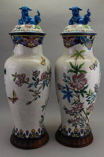
Sold2017(2) Large Antique French Longwy Covered Vases(2) Antique French Longwy Covered Vases. These vases come apart into 3 sections (top, body and base). Tops having stylized blue foo dogs mounted to lids. Vases having butterfly and flower motif througSee Sold Price
Sold2016Large Antique German Silver Coin Mounted TankardLarge Antique German Silver Coin Mounted Tankard. Hallmarked. Appears to be German in origin. Having a light gilt wash in places. Mounted with five silver / silver tone coins. 1st Germany (Mansfeld-ArSee Sold Price
Featured19 hrs LeftJasper52PACIFIC OCEAN currents British French German US Spanish colonies. LETTS 1889 map$15
3 days LeftTrillium Antique Prints & Rare BooksMitchell's A New Universal Atlas.. - Volume with 73 Maps$1,000(1 bid)
3 days LeftTrillium Antique Prints & Rare BooksBraun & Hogenberg, pub. 1575 - View of Innsbruck, Germany$100
Trading Post Auctions19th Century Charles X Period Empire Gilt Bronze Candelabras- A Pair$160(3 bids)
May 09World of Antiques, Inc.Large 23" Boulle Pendulum Mantle Clock Louis XIV Style, 20th Century German Clock By Kienzle$500
May 10New England Auctions - Fred GiampietroPair of Large German Copper-Colored Ceramic Crucible Planters$50(1 bid)
Jun 16Broward Auction GalleryKarl Herbsthoffer (France,Germany,1821-1876) oil painting antique$10(1 bid)
5 days LeftCurated Gallery AuctionsAntique French Impressionist River Valley Landscape Original Large Oil Painting$10(1 bid)
Jun 16Broward Auction GalleryATTRIB Julius Von Payer (Austrian,1841-1915) oil painting antique$20(2 bids)
May 14Fleischer's Auctions1755 Map Partie de l'Amerique Septentrionale, qui comprend Le Cours de L'Ohio...$200(3 bids)
5 days LeftCurated Gallery AuctionsLudwig Heitmuller (1863-1933) "Early Morning" Antique American Impressionist Seascape Oil Painting$10(1 bid)


![Antique French Copper Engraved Colored Map, Amsterdam: 18th century antique French copper engraved and hand colored maps of Amsterdam, Netherlands titled "Lemouicum, Auctore Jo. Faiano M.L. - Lymosin [on sheet with] Topographia Limaniae, Auctore Gabriele](https://p1.liveauctioneers.com/6377/128239/65869733_1_x.jpg?height=310&quality=70&version=1540604375)