Sold20221853 Immense Williamson Map of California -- General Map of Explorations and Surveys In CaliforniaTitle: 1853 Immense Williamson Map of California -- General Map of Explorations and Surveys In California under the direction of the Hon. Jefferson Davis, Secretary of War… Cartographer: R WilliSee Sold Price
Sold20211853 Williamson Map of California's Tejon Pass Area --Title: 1853 Williamson Map of California's Tejon Pass Area -- Map of the Passes in the Sierra Nevada from Walker's Pass to the Coast Range under the direction of the Hon. Jefferson Davis, Secretary ofSee Sold Price
Sold2023Williamson, Lieut. R. S. 1856 Map. California, New Mexico, Texas, Mexico"United States & Mexican Boundary Survery" Lithograph Map Published 1853-61, Washington for "Reports of explorations and surveys, to ascertain the most practicable and economical route for a railroadSee Sold Price
Sold2023Williamson, Lieut. R. S. 1856 Map. California - Tejon Pass & Canada de las Uvas"Geological Map of the Tejon Pass & Canada de las Uvas and the Vicinity. Including the Pass of San Francisco & Williamsons Pass"Lithograph Map Published 1853-61, Washington for "Reports of explorationSee Sold Price
Sold2023Williamson, Lieut. R. S. 1856 LG HC Map. California - First Geological Map"Geological Map of a Part of the State of California" Explored in 1855 by Lieut R. S. Williamson. Prepared to accompany the Report of William P. Blake. THE FIRST GEOLOGY MAP OF CALIFORNIA. Hand ColoreSee Sold Price
Sold2023Williamson, Lieut. R. S. 1856 Map. Vicinity of San Francisco California"Geological Map of the Vicinity of San Francisco" by William P. Blake. Lithograph Map Published 1853-61, Washington for "Reports of explorations and surveys, to ascertain the most practicable and econSee Sold Price
Sold2023Williamson, Lieut. R. S. 1856 HC Map. San Diego & Colorado River California"Geological Map of the Country Between San Diego and the Colorado River California" By W. P. Blake. Hand Colored Lithograph Map Published 1853-61, Washington for "Reports of explorations and surveys,See Sold Price
Sold20231855 Williamson Map of San Francisco Bay to Oregon -- Map No. 1 From San Francisco Bay to theTitle: 1855 Williamson Map of San Francisco Bay to Oregon -- Map No. 1 From San Francisco Bay to the Northern Boundary of California from Explorations and Surveys Made Under the Direction of Hon. JeffSee Sold Price
Sold2017Four 19th Century Maps Pertaining to the Western Unitedas follows: Geological Map of a Part of the State of California Explored in 1855 by Lieut. R. S. Williamson U.S. Top Engr (Washington: War Department, 1856); color-coded (24.5 x 19.25 in.) (Some edgeSee Sold Price
Sold20211855 Williamson/Abobot Map ot Western Oregon -- Map No.Title: 1855 Williamson/Abobot Map ot Western Oregon -- Map No. 2 from the Northern Boundary of California to the Columbia River from Explorations and Surveys Made Under the Direction of Hon. JeffersonSee Sold Price
Sold2023Williamson, Lieut. R. S. 1856 LG Chart. California - Bernardino Sierra, San Pedro"Geological Section of the Bernardino Sierra from the Great Basin to the Pacific ocean at San Pedro" by William P. Blake. Lithograph Map Published 1853-61, Washington for "Reports of explorations andSee Sold Price
Sold2023Williamson, Lieut. R. S. 1856 LG Chart. California - Colorado River to the Pacific Ocean"Geological Section from the Colorado River to the Pacific Ocean" by William P. Blake. Lithograph Map Published 1853-61, Washington for "Reports of explorations and surveys, to ascertain the most pracSee Sold Price
Sold2023Williamson, Lieut. R. S. 1856 LG Chart. California - Coast Mountains & Sierra Nevada"Geological Section of the Coast Mountains and Sierra Nevada" by W. P. Blake. Lithograph Map Published 1853-61, Washington for "Reports of explorations and surveys, to ascertain the most practicable aSee Sold Price
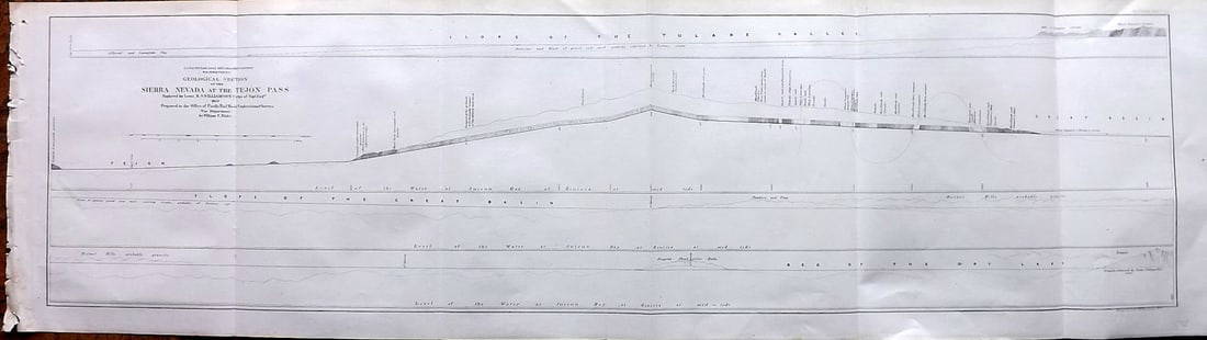
Sold2023Williamson, Lieut. R. S. 1856 LG Chart. California - Sierra Nevada & Tejon Pass"Goelogical Section of the Sierra Nevada at the Tejon Pass" by R. S. Williamson. Lithograph Map Published 1853-61, Washington for "Reports of explorations and surveys, to ascertain the most practicablSee Sold Price
Sold2023Williamson, Lieut. R. S. 1856 LG Chart. California - Bernadino Pass, San Bernardino, Colorado Desert"Geological Sections of the Bernadino Pass" Lithograph Map Published 1853-61, Washington for "Reports of explorations and surveys, to ascertain the most practicable and economical route for a railroadSee Sold Price
Sold2023Williamson, Lieut. R. S. 1856 LG Chart. California - Colorado Desert"Sections of the Colorado Desert" Explored by Lieut R. S. Williamson. Lithograph Map Published 1853-61, Washington for "Reports of explorations and surveys, to ascertain the most practicable and econoSee Sold Price
Sold20171703 Scherer - World Map [California as an Island]Title: World Map [without title] "Map maker: Heinrich Scherer, Atlas Marianus" "Place and Year: Munich, 1703" "Dimensions: 23.6 x 35.5 cm (9.3 x 14 in)" "Technique: Copperplate engraving" "Coloring: USee Sold Price
Sold20171749 MAP CALIFORNIA AS AN ISLAND, JACQUES CHIQUETFramed map, c. 1749, "L’AMERIQUE SEPTENTRIONALE qui fait partie des Indes Occidentales. Dressée selon les dernieres Relations des Voiageurs et Suivant les nouvelles Observations de Mur. de lSee Sold Price
Sold2021Map California during the ConquestHeading: Author: U.S. War Department Title: [Untitled map of California from Bodega Bay to San Diego, with inset of lower tip of Baja California and the Gulf of California] Place Published: [WashingtSee Sold Price
Sold20231790 George Anson World Voyage Spain South America HUGE MAP California Island1790 George Anson World Voyage Spain South America HUGE MAP California Island George Anson was an 18th-century British Navy admiral who is noted for his important world voyage in which he circumnavigaSee Sold Price
Sold2021de Fer, Nicolas 1717 World Map. California as Island"Mappe-Monde ou Carte Generale de la Terre" Copper Engraved Map Published 1717, Paris for "Introduction a la Geographie" by Nicolas de Fer. Folds as issued. Paper Size: 14 x 10 inch (36 x 25cm) Very mSee Sold Price
Sold2018Diderot/Vaugondy: Antique Map California & West AmericaTitle/Content of Map: Carte De La Californie Et Des Pays Nord Ouest separes de L'Asie par le Detroit d'Anian… Cartographer: Diderot/de Vaugondy Place & Date: Paris / 1772 Size: 14 3/8" x 11 7/8" ConSee Sold Price
Sold2021Soil Map California Imperial sheet (second survey)Title: Soil Map California Imperial sheet (second survey) Cartographer: J. Garnett Holmes Publisher: U.S. Department of Agriculture Bureau of Soils Height: 24.1 Width: 16 Shows "Salton Sink" before itSee Sold Price
Sold20221926 Union Oil Company Road Map California, Washington, Oregonrated 6.5, 9"x4", cover is slightly yellow, has wear on the inside.See Sold Price
May 16Potter & Potter AuctionsPictorial Map of Hollywood and Vicinity / Hollywood Film Ca...$125(1 bid)
May 14Akiba Galleries(2 Pc) Allain Manesson Mallet Description De L'Univers 2 Vol. German Translation$200(1 bid)
May 16Potter & Potter AuctionsLINDGREN, Hjalmer “Jolly” (1895–1952). A Hysterical Map of ...$150(1 bid)
May 16Potter & Potter AuctionsLISTER, James Wren (1897 – 1952). Avalon Town / Santa Catal...$100(1 bid)
6 days LeftRail & Road AuctionsSeven Panama Pacific Line Steamship Travel Guides, Timetable, and Menu - 1927 to 1939$30
May 11Trillium Antique Prints & Rare BooksWilkes - Pair of Maps of California and the Pacific Ocean$100
5 days LeftHunt and Peck Estate Services, Inc.1849 Alex Mackay 1st US Ed. 2 Vol. "The Western World or Travels in the United States in 1846-1847"$50
May 14Fleischer's Auctions1755 Map Partie de l'Amerique Septentrionale, qui comprend Le Cours de L'Ohio...$200(3 bids)
1 day LeftTremont Auctions17th century original map 1676 "Virginia and Maryland" by John Speed. 2 sided framing. Overall:$650(3 bids)


![1703 Scherer - World Map [California as an Island]: Title: World Map [without title] "Map maker: Heinrich Scherer, Atlas Marianus" "Place and Year: Munich, 1703" "Dimensions: 23.6 x 35.5 cm (9.3 x 14 in)" "Technique: Copperplate engraving" "Coloring: U](https://p1.liveauctioneers.com/5584/112867/57947644_1_x.jpg?height=310&quality=70&version=1511920104)

![Map California during the Conquest: Heading: Author: U.S. War Department Title: [Untitled map of California from Bodega Bay to San Diego, with inset of lower tip of Baja California and the Gulf of California] Place Published: [Washingt](https://p1.liveauctioneers.com/642/218849/112379356_1_x.jpg?height=310&quality=70&version=1631988625)


