Sold2022Findlay, Alex C1835 Pair Maps. France & Holland/BelgiumSteel Engraved Map Published C1835 by Thomas Kelly, London for "A New and Universal English Dictionary" by the Rev. James Barclay. Maps Drawn & Engraved by Alexander Findlay. Paper Size: 10.5 x 8 inchSee Sold Price
Sold2020Levasseur, Victor C1850-69 Pair Decorative Maps. FranceSteel Engraved Decorative Maps Published C1850, Paris for "Atlas National Illustre" by Victor Levasseur. Paper Size: 20.5 x 14.5 inch (52 x 37cm) Good ConditionSee Sold Price
Sold2021Guthrie, William 1798 Pair of Maps. FranceCopper Engraved Map Published 1798, London for "A New Geographical, Historical and Commercial Grammar..." by William Guthrie. The maps are by John Senex, Thomas Kitchin and others. Folds as issued. PaSee Sold Price
Sold2021Guthrie, William 1799 Pair of Maps. Europe, FranceCopper Engraved Maps Published 1799, London for "A New Geographical, Historical and Commercial Grammar..." by William Guthrie. The maps are by D. Ogilby & Son and others. Folds as issued. Paper Size:See Sold Price
Sold2022Butler, Samuel 1842 Pair of Maps of FranceSteel Engraved Map Published 1842, London for "An Atlas of Modern Geography" by Samuel Butler. Drawn & Engraved by Sidney Hall. Centre fold as published. Original outline hand colour. Paper Size: 10.5See Sold Price
Sold2017PAIR OF 1764 MAPS OF FRANCE BY LOUIS DESNOSTwo maps of France by Louis Charles Desnos, one during the Reign of Louis XIV, the other during the Reign of Louis XV. Both dated 1764. Measures 14 3/8 x 10.5 inches. We happily provide seamless in-hoSee Sold Price
Sold2018Levasseur, Victor 1859 Pair of Maps of Paris, France"Seine et Oise" and "Dept de la Seine" Steel Engraved Map Published 1859, Paris for "Atlas National Illustre" by Victor Levasseur. Paper Size: 20.5 x 14.5 inch (52 x 37cm) Good ConditionSee Sold Price
Sold2021Meyer, Joseph 1890's Pair of Maps of Paris, FranceLithograph Maps Published 1893-97, Leipzig for "Meyers Konversations-Lexikon" by Joseph Meyer et al. Centre fold as published. Paper Size: 12 x 9.5 inch (31 x 25cm) Good ConditionSee Sold Price
Sold2021Group of 5 Vintage Pairs of Long GlovesGroup of 5 Vintage Pairs of Ladies Long Gloves including a black leather pair from France, an ivory fabric pair, and 3 pairs in different black fabrics. In good condition, some minor spots. In house FSee Sold Price
Sold2024Paterson & Mogg 1822 Pair of British Road Maps. Rye, Eastbourne, SouthamptonCopper Engraved Maps Published 1822, London for "Paterson's Roads?" by Edward Mogg. Folds as issued. Paper Size: 10 x 8 inch (26 x 20cm) Minor toning, Tight top margin on Southampton, slightly affectiSee Sold Price
Sold2024Paterson & Mogg 1822 Pair of British Road Maps. Isle of Thanet & WightCopper Engraved Maps Published 1822, London for "Paterson's Roads?" by Edward Mogg. Folds as issued. Paper Size: 10 x 8 inch (26 x 20cm) Minor toning, otherwise fineSee Sold Price
Sold2024Paterson & Mogg 1822 Pair of British Road Maps. Deal, Hythe, Shoreham, ChichesterCopper Engraved Maps Published 1822, London for "Paterson's Roads?" by Edward Mogg. Folds as issued. Paper Size: 10 x 8 inch (26 x 20cm) Minor toning, Tight top margin on Deal, slightly affecting titlSee Sold Price
Sold2020Ireland 1824-C1850 Pair of Maps by Arrowsmith & HughesSteel Engraved Map Published 1824 by Archibald Constable, Edinburgh for "The Edinburgh Gazetteer, or Compendious Geographical Dictionary" Map by Aaron Arrowsmith. Together with Steel Engraved Map withSee Sold Price
Sold20231876 Mitchell Map of France, Spain, Portugal, Switzerland [verso] Ireland and Scotland -- Map ofTitle: 1876 Mitchell Map of France, Spain, Portugal, Switzerland [verso] Ireland and Scotland -- Map of France, Spain and Portugal [verso] Ireland in Provinces and Counties [and] County Map of ScotlanSee Sold Price
Sold2023(2) pair French leather gloves, incl. YSL(2) pair French leather gloves, incl. YSL, 21st c., Made in France, (1) pair butterscotch leather with fold over linen cuff, size 7.5, Yves Saint Laurent, (1) pair black leather with caramel fold overSee Sold Price
Sold2021Jacques Adnet, Chairs, pairJacques Adnet Chairs, pair France, c. 1950leather, brass 32 h × 29 w × 30 d in (81 × 74 × 76 cm) Provenance: Acquired in 1999 from Wyeth, New York by tSee Sold Price
Sold2022Jacques Adnet, Nightstands, pairJacques Adnet Nightstands, pair France, c. 1950leather over steel and wood, oak, brass 26 h × 25.25 w × 15 d in (66 × 64 × 38 cm) This work will ship fromSee Sold Price
Sold2024Jacques Adnet Attribution (French, 1900-1984) Pair of Stools FranceJacques Adnet Attribution (French, 1900-1984) Pair of Stools France brass, leather 18 h x 10 w x 10 d in Property from a Private Collection, Chicago, Illinois and Charleston, South CarolinaSee Sold Price
Sold2016French, lounge chairs, pairFrench lounge chairs, pair France, c. 1935leather, lacquered wood, brass38.5 w x 41 d x 33.5 h in (98 x 104 x 85 cm) Provenance: Private Collection, New YorkSee Sold Price
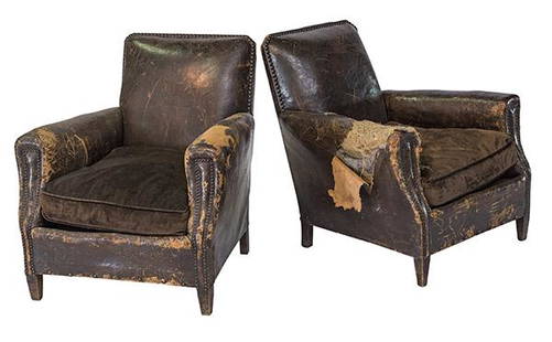
Sold2020French Art Deco Club ChairsClub chairs, pair, France. 1910-1925, leather, mahogany. 29 1/2w x 31d x 31hSee Sold Price
Sold2017Two 17th Century Maps of England/Scotland andTwo 17th Century Maps of England/Scotland and Ireland/France. Two hand-colored engravings, with text in French, with genealogies of the kings Larger: 15" x 19" Frames: 22.75" x 26.75"See Sold Price
Sold2019Three Maps from Nicholas Tindal's (1687-1774),Three Maps from Nicholas Tindal's (1687-1774), Continuation Of Rapin's History, "A Map of England and Wales," 1757, "A Map of the Kingdom of Ireland," and "A Map of France," H. - 21 in., W. - 17 in. aSee Sold Price
Sold2024Blackie (Pub) 1882 Lot of 6 Large Maps of Europe7 Maps on 6 Sheets. Incl Europe Continent, Belgium/Netherlands, Denmark, British Isles, Ireland, France, and Sweden/Norway. Lithograph Maps Published 1882 by Blackie & Son, London for "The ComprehensiSee Sold Price
Sold2021Encyclo. Britannica C1830 Set of 4 Maps on 8 SheetsIncl England/Wales, France, Ireland and Germany. Steel Engraved Map Published 1830-42, Edinburgh for "Encyclopedia Britannica" Seventh Edition. Centre fold as issued. Paper Size: 16 x 11 inch (40 x 28See Sold Price
3 days LeftJasper52Antique French Napoleon III Carved Armchairs Newly Upholstered in Distressed Leather - Pair$2,400
Jun 15Crescent City Auction GalleryPair of New Orleans Sanborn Fire Insurance Mock-Up Skeleton Maps of the French Quarter, 1910-1911,$250
3 days LeftJasper521794 de la Rochette Map of the English Channel and Bay of Biscay -- A Chart of the British Channel$240
3 days LeftJasper52Large map engraving of Paris 1822 Auvray, Marchand d'Estampes , Quai Malaquais$480
4 days LeftBonhamsPETER HVIDT (1916-1986) & ORLA MØLGAARD-NIELSEN (1907-1993) Paire de fauteuils Boomerang Pr...€2,500
3 days LeftA.H. Wilkens Auctions & AppraisalsPAIR GERMAN SILVER GILT & GLASS SWEET MEAT BASKETSCA$1,000
C & T Auctioneers and Valuers LtdA pair of medals to recipient in the London Irish Rifles who was killed in action during the German£50(1 bid)


![1876 Mitchell Map of France, Spain, Portugal, Switzerland [verso] Ireland and Scotland -- Map of: Title: 1876 Mitchell Map of France, Spain, Portugal, Switzerland [verso] Ireland and Scotland -- Map of France, Spain and Portugal [verso] Ireland in Provinces and Counties [and] County Map of Scotlan](https://p1.liveauctioneers.com/5584/283091/149355449_1_x.jpg?height=310&quality=70&version=1680038985)