Sold2022SDUK (Pub) 1833-51 Lot 3 Maps. Sweden Denmark NorwaySteel Engraved Map Published 1829-45, London for "Maps by the Society for the Diffusion of Useful Knowledge" Paper Size: 17 x 14 inch (43 x 36cm) One with margin faults, otherwise fineSee Sold Price
Sold2024Blackie (Pub) 1882 Lot of 6 Large Maps of Europe7 Maps on 6 Sheets. Incl Europe Continent, Belgium/Netherlands, Denmark, British Isles, Ireland, France, and Sweden/Norway. Lithograph Maps Published 1882 by Blackie & Son, London for "The ComprehensiSee Sold Price
Sold2018Sweden Denmark Norway & FinlandTitle/Content of Map: Sweden Denmark Norway & Finland Date: 1763 ca. Cartographer: JEFFERYS, T. Size: 7.25X8.75 Small inset of Greenland.Old outline color Please note that this lot has a confidentialSee Sold Price
Sold2019Walker, John 1795 Lot of 4 Maps. Germany, SwitzerlandAlso Turkey in Europe and Sweden, Denmark, Norway. Copper Engraved Maps Published 1795, London for "Elements of Geography, and of Natural and Civil History" by John Walker. Centre fold as published. PSee Sold Price
Sold2024Russell & Allen (Pub) 1812 Map. Northern States of Europe. Denmark Norway Sweden Russia PrussiaFolio Copper Engraved Map Published 1812 by Russell and Allen, Manchester for "A New And Commercial System Of Geography" Paper Size: 15.5 x 9 inch (39 x 23cm) Tone marks in margin, otherwise Good CondSee Sold Price
Sold2019Maps 1824-1911 Mixed Lot of 10 Antique MapsIncl Sweden, Denmark, Norway, Macedonia/Thrace, Asia Minor, Egypt, Siberia, England/Wales, Switzerland, and North Africa. Examples by Delamarche, Barthelemy, Becker, Bryce and Encyclopaedia BritannicaSee Sold Price
Sold2019Butler, George 1874 Lot of 5 Maps of EuropeIncl Holland/Belgium, Sweden/Norway/Denmark, Russia, Italy, Turkey in Europe. Lithograph Maps Published 1874, London for "The Public School Atlas of Modern Geography" by Rev. George Butler. Paper SizeSee Sold Price
Sold2020LOT OF THREE ANTIQUE c.1819 FRAMED MAPSLOT OF THREE ANTIQUE c.1819 FRAMED MAPS - EAST INDIES, DENMARK, SWEDEN, & NORWAY Height: 16 1/2 & 8 in. by Width: 18 1/2 & 10 in.See Sold Price
Sold2022SCANDINAVIA. Sweden, Norway, and Denmark. Populations. SDUK 1857 old mapTITLE/CONTENT OF MAP: 'SWEDEN, NORWAY, AND DENMARK' DATE PRINTED: 1857 IMAGE SIZE: Approx 41.0 x 33.5cm, 16.25 x 13.25 inches (Large) TYPE: Antique steel engraved map with original hand colouring CONDSee Sold Price
Sold2021Turner, Richard 1808 Lot of 12 Miniature MapsIncl Germany, Holland, Spain/Portugal, Switzerland, Poland/Prussia, Denmark, Sweden/Norway, Russia, Hungary, Turkey, and Great Britain. Copper Engraved Map Published 1808, London for "A New and Easy ISee Sold Price
Sold2022Butler, Samuel 1842 Lot of 5 European MapsIncl Germany/Prussia, North Italy/Switzerland, Russia, Denmark/Sweden/Norway, and Holland/Belgium. Steel Engraved Map Published 1842, London for "An Atlas of Modern Geography" by Samuel Butler. DrawnSee Sold Price
Sold2018Weller, F. S. C1890 Lot of 12 Antique MapsIncl German Empire, Switzerland, Holland/Belgium, Austria/Hungria, Russia, Asia, Africa, Sweden/Norway & Denmark, France, Australasia, Eastern Australia and New Zealand, and The World. Lot of 12 LithoSee Sold Price
Sold2023Gross, Alexander 1920 Lot of 26 Large Maps. EuropeIncl Germany, Austria, Russia, Netherlands, Belgium/Luxembourg, Norway/Sweden, Denmark/Iceland, Switzerland, Italy, France/Switzerland, Spain/Portugal, Europe Continent. Large Lithograph Maps PublisheSee Sold Price
Sold2022Barclay & Becker C1845 Lot of 4 European MapsIncl France, Holland/Belgium, Norway/Sweden/Denmark/Finland and Turkey/Hungary. Steel Engraved Map Published C1845, London for "A Complete and Universal English Dictionary" by the Rev. James Barclay aSee Sold Price
Sold2023Maps 19th Cent. Mixed Lot of 20Incl India, UK, France, China, Iran, Sweden/Norway, Denmark, British Empire, Venice, Austria, Russia and Switzerland. Examples by Findlay/Kelly, Reclus, Baedeker, Blackie, Fullarton, William MackenzieSee Sold Price
Sold2021Brockhaus (Pub) 1890's Mixed Lot of 12 Antique MapsIncl Balkans, Central Asia, Asia Political, Holy Land/Persia, European Railway Development, German Republic Politica, Denmark/Sweden, North France, Historial Map of France, History of the Mapping of tSee Sold Price
Sold2019Encyclopaedia Britannica 1911 Mixed Lot of 16 MapsIncl French West Africa, Turkestan, French Indo-China & Siam, Germany, Central America, Northern/Southern Hemisphers, Ireland, Polar Regions, Denmark, France, Norway/Sweden, Spain and Portugal, FranceSee Sold Price
Sold2019Laurie & Whittle (London), "A New Map of the NorthernLaurie & Whittle (London), "A New Map of the Northern States the Kingdoms of Sweden, Denmark,and Norway," 1794, hand colored, H. - 21 3/8 in., W. - 28 3/4 in.See Sold Price
Sold2020Rapkin, John 1860 Lot of 5 European MapsIncl Belgium, Switzerland, Denmark, Turkey in Europe, and Sweden/Norway. Steel Engraved Maps Published 1860 by The London Printing & Published Company, London for "The Royal Dictionary-Cyclopedia forSee Sold Price
Sold2022Universal Atlas 1893 Lot of 22 Maps of EuropeIncl Ireland, Ethnographic, France, Belgium/Luxemburg, Holland, Denmark, Germany, Austria/Hungary, Greece, Italy, Scandinavia, Norway/Sweden, Bohemia, Sicily/Sardinia etc. Lithograph Maps Published 18See Sold Price
Sold2022Times Atlas 1895 Mixed Lot of 18 MapsIncl Germany, Holland, Denmark, Ireland, Bohemia, Atlantic, Belgium/Luxemburg, Alps, Hungary, Mediterranean, Caucasus, Norway/Sweden, Southern Sandinavia etc. Lithograph Map Published 1895, London forSee Sold Price
Sold2019Bryce, James 1881 Lot of 10 Maps of EuropeIncl Turkey in Europe, Austria-Hungary, German Empire, Denmark, Denmark, German Empire, Switzerland, France, Hispania/Germania, Italia, Sweden/Norway. Lithograph Maps Published 1881, London for ""TheSee Sold Price
Sold2019The Times 1895 Lot of 8 Maps of EuropeIncl Ethnographic Map of Europe, Holland, Belgium and Luxemburg, Denmark, Alsace/Bavaria, Ethnographic Map of Austria-Hungary, Hungary, and Norway/Sweden. Lithograph Maps Published 1895, London for "TSee Sold Price
Sold2023Times Atlas 1895 Mixed Lot of 6 MapsIncl Norway/Sweden, Holland, Ireland, Scandinavia, Alsace-Lorraine/Bavaria and Denmark. Lithograph Maps Published 1895, London for "The Times Atlas" Paper Size: 16.5 x 10.5 inch (42 x 27cm) Good CondiSee Sold Price
7 days LeftRail & Road AuctionsScandinavian-American Line Tin Lithograph Advertising Sign of Frederick VIII By Ferdinand Worms$170
6 days LeftHunt and Peck Estate Services, Inc.Lot of 3 small maps from Scott's Gazeteer "Vermont, New Hampshire and N.W. Territories"$100(1 bid)
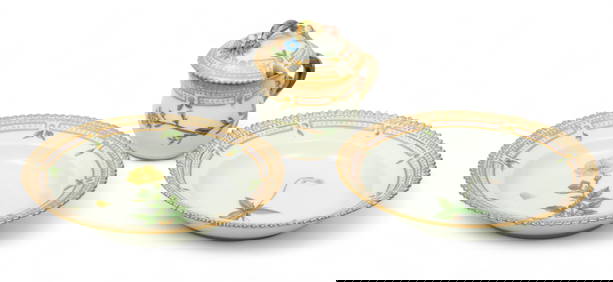
May 16DuMouchellesRoyal Copenhagen (Danish) Flora Danica Porcelain Fruit Bowls & Mustard/Custard Cup, H 3.25" W 2.5" L$100
471 Lots AwayBright Star Antiques Co.3pc. Lot of Framed Owl Prints 51 3/4"H x 38"L / 50"H x 36 1/2"L$25(1 bid)
BonhamsMID-CENTURY MODERN WALL-MOUNTED CABINETS, Norway, c. 1965, teak, teak veneer, glass, unmarked, s...$200
BonhamsEIGHT EJNER LARSEN AND AKSEL BENDER MADSEN FOR FRITZ HANSEN DINING CHAIRS, Denmark, c. 1960, tea...$750(1 bid)
May 11Cape Ann AuctionHans Wegner Danish Modern AT-33 Teak and Oak Sewing Table for Andreas Tuck$150(1 bid)
BonhamsFRITZ HANSEN TEAK DINING TABLE, Denmark, c. 1960, teak, teak veneer, paper label 'FH Made in Den...$260
BonhamsDANISH MID-CENTURY MODERN CHEST OF DRAWERS ATTRIBUTED TO NILS JONSSON, c. 1960, teak, back stamp...$220(3 bids)
3 days LeftHudson Valley Auctioneers LLC Beacon NYLot sterling flatware, partial set, includes 16 small spoons, 3 large spoons, 5 sorbet spoons, 3$1,000(3 bids)