Sold202143 LANTERN SLIDES, EGYPT AND VICINITY, BY VESTER42 of the 43 slides have the same text at top and bottom: "AMERICAN COLONY PHOTOGRAPHERS" and "FR. VESTER & Co, Jerusalem, Palestine." All 43 have handwritten captions: Flocks in Fields of Memphis, CoSee Sold Price
Sold2024Middle East.- Holy Land.- [American Colony - Jerusalem Album], 48 vintage albumen prints, [c.1920].Middle East.- Holy Land.- [American Colony - Jerusalem Album], 48 vintage albumen prints, each c.285 x 215 mm, captioned in English and French and numbered in the negative, many with "American ColonySee Sold Price
Sold2022ENGRAVED MAP OF THE AMERICAN COLONIES BY JEAN PALAIRET 1775 17.5” x 23” sight. FramedENGRAVED MAP OF THE AMERICAN COLONIES BY JEAN PALAIRET1775Double-page “Carte des Possessions Angloises & Françoises du Continent de l'Amérique". After Mitchell.17.5” x 23See Sold Price
Sold2023Map of the American Colonies from December, 1754This map is titled 'An Accurate Map of the English Colonies in North America bordering on the River Ohio', a scarce early map of the British Colonies in North America and one of the earliest maps to aSee Sold Price
Sold2022Vintage Middle Eastern PrintsPair of prints measuring 16" x 20" matted, unframed. They are the "American Colony Jerusalem" prints impressed in bottom with right corner.See Sold Price
Sold2022Two More Vintage Middle Eastern PrintsPair of prints measuring 16" x 20" matted, unframed. They are the "American Colony Jerusalem" prints impressed in bottom with right corner.See Sold Price
Sold2018Morden: Antique Map of Florida & the Great Lakes, 16931693 map of Florida and the Great Lakes by Robert Morden. 5 x 5 inches. A very special map--one of the very earliest obtainable English maps of the American colonies. A Map of Florida and Ye Great LakSee Sold Price
Sold2021American colonies, 1755-1768, by R. Vaugondy. ParisTitle: American colonies, 1755-1768, by R. Vaugondy. Paris Date/Period: 1755-1768 Materials: Copperplate engraved Size: 24 x 18 1/2” A very interesting and important British American colonies mapSee Sold Price
Sold20171863 BIBLE Holy Land Land of the Book1863 BIBLE Holy Land Land of the Book Thomson Illustrated Jerusalem Maps A rare American printing of William Thomson’s “Land and the Book” – an illustrated two-volume work of Bible stories andSee Sold Price
Sold2016AN AMERICAN REPLOGLE COMMANDER II 16" TERRESTRIALAN AMERICAN REPLOGLE COMMANDER II 16" TERRESTRIAL STANDING FLOOR GLOBE, BY REPLOGLE GLOBES, INC., SECOND HALF 20TH CENTURY, the polychrome cartographer's map overlay and political raised relief map stSee Sold Price
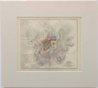
Sold2016Modern Jerusalem, 1858Map: Jerusalem before the Roman Destruction Publishing: Sarony & Major, 1858 Medium: Hand colored lithograph Size: 13.5 x 15 inches Napoleon Sarony (1821-1896) was an American lithographer and a highlSee Sold Price
Sold20241777 Revolutionary War Map America Septentrionalis1777 hand-colored map published by Homann Heirs, Nuremberg, showing the British colonies in North American, published in the midst of the American Revolution, entitled "America Septentrionalis a DominSee Sold Price
Sold2023South America (Relief). Rivers Mountains 1907 old antique map plan chartTitle: South America (Relief). Rivers Mountains 1907 old antique map plan chart Description: South America (Relief)' by Scientific American (1907). Vintage colour map, 21.0 x 17.5cm, 8.25 x 7 inches;See Sold Price
Sold2020Illustrated Van Loon Hand-Colored World Map, 1932Hendrik Willem Van Loon (Dutch-American, 1882-1944). Illustrated World Map, 1932. A hand colored outlined pictorial map of the world on Mercator projections with topographical relief shown pictoriallySee Sold Price
Sold2015Scarce Hudson-Fulton Celebration TapestryA woven tapestry with the Roman numerals for 1626 at center top for the year Manhatten was purchased from the Native Americans by the Dutch, and showing map of the Dutch colony in North America entitlSee Sold Price
Sold20211763 Map of the 13 British Colonies in AmericaHistoric Maps 1763 Map of "The British Government in Nth. America, Laid down agreeable to the Proclamation of Oct. 7, 1763" 1763-Dated Colonial Period, Map titled, "The British Government in Nth. AmerSee Sold Price
Sold2022c 1760 Northern Colonies French + Indian War MapHistoric Maps Louisiana & Florida French & Indian War Era Map c. 1760 c. 1760 French & Indian War Era, Hand-Colored Map of Pennsylvania and New England titled, "Carte de la Partie Nord, Des Etats UnisSee Sold Price
Sold20231754 An Accurate Map Of the English Colonies in North America1754 An Accurate Map Of the English Colonies in North America bordering on the River Ohio, by John Hinton. Covers the Carolinas to the Great Lakes and Casco Bay off the coast of present-day Maine. PubSee Sold Price
Sold2018Antique John Smith Atlantic Region Map Virginia OrigState 10: Page 41, numbers changed to 1690 and 1691. A true piece of American history, not a reproduction!Fine example of John Smith's map of the newly formed Virginia colony, one of the true milestonSee Sold Price
Sold2021Arto Monaco Relief Map of the Adirondack ParkNYS Map of the Adirondack Park "Just for Fun". Original 3D map. Overall size 33" x 43"See Sold Price
Sold2024Stephen Austin Autographed Loan LetterStephen F. Austin autographed "TEXIAN LOAN" letter. He was the founder of the first American colony in Texas. Framed with print. Letter sight 9" x 8", frame overall 14" x 19".See Sold Price
Sold20231656 ANNE & HANNAH BRADSTREET LAND GRANT DOCUMENTAnne Bradstreet (née Dudley; March 8, 1612 – September 16, 1672) was the most prominent of early English poets of North America and first writer in England's North American colonies to be pSee Sold Price
Sold2023Hugh Weiss 1925-2007 Pop Art American Map PaintingHugh Weiss (American French, 1925-2007). An original oil painting on canvas. Titled "American Sandwich." A subversive modern Pop Art landscape depicting a stylized map of the 48 contiguous United StatSee Sold Price
Sold2023JOHN COLEMAN (B1949) NATIVE AMERICAN RELIEF PLAQUEFramed composite relief sculpture, "Man's Prelude to Honor," incised lower right John E. Coleman (American, b.1949), numbered 16/ 50, restoration to spear point, sight: approx 48.5"h, 22.5"w, overall:See Sold Price
5 hrs LeftFleischer's Auctions1755 Map Partie de l'Amerique Septentrionale, qui comprend Le Cours de L'Ohio...$200(3 bids)
2 days LeftZikorn Arts & History ObjectsJames L. Barton: Story of Near East Relief (1915-1930)$30(2 bids)
2 days LeftFreeman's | HindmanDean Cornwell (American, 1892-1960) Golden Gate, Jerusalem, c. 1925-1926$1,000
2 days LeftPotter & Potter AuctionsPan American Airways World System Map. 1956. Art by John Br...$200
2 days LeftJasper52Art Nouveau Solid Bronze Medallion — Award, Botanical Garden, The American Home$120(1 bid)


![Middle East.- Holy Land.- [American Colony - Jerusalem Album], 48 vintage albumen prints, [c.1920].: Middle East.- Holy Land.- [American Colony - Jerusalem Album], 48 vintage albumen prints, each c.285 x 215 mm, captioned in English and French and numbered in the negative, many with "American Colony](https://p1.liveauctioneers.com/5458/320809/172327621_1_x.jpg?height=310&quality=70&version=1708945779)