Sold2016Map of Maryland, Delaware and Washington, DC, 1796Original engraving from Morse’s Universal Geography published by Thomas & Andrews, Boston, 1796. Dimensions: 12 3/4” x 15” No Reserve This item ships from Ocean View, DE.See Sold Price
Sold20211855 Colton Map of Maryland, Delaware and Washington DCTitle: 1855 Colton Map of Maryland, Delaware and Washington DC -- Delaware and Maryland Cartographer: J Colton Year / Place: 1855, New York Map Dimension (in.): 11.8 X 15.8 in. This is a very nice mapSee Sold Price
Sold20211831 Hinton Map of Virginia, Maryland, Delaware andTitle: 1831 Hinton Map of Virginia, Maryland, Delaware and Washington DC -- Map of the States of Virginia, and Maryland Cartographer: J Hinton Year / Place: 1831, London Map Dimension (in.): 9.7 X 15.See Sold Price
Sold2022FRAMED MAP OF DELAWARE & MARYLAND (& DC)"Johnson's Delaware and Maryland" by A. J. Johnson, 1860, published in NYC. Hand colored engraving. Includes vignette map of "Washington City", giving an 1850 population of 29,815 Whites, 8,073 Free CSee Sold Price
Sold2016Maryland, Delaware and Washington, DC, 1796Original engraving from Morse’s Universal Geography published by Thomas & Andrews, Boston, 1796. Dimensions: 12 3/4” x 15” No Reserve This item ships from Ocean View, DE.See Sold Price
Sold2017USA. Pennsylvania New Jersey Maryland Delaware DCTitle/Content of Map: 'NORTH AMERICA, SHEET VII., Pennsylvania, New Jersey, Maryland, Delaware, Columbia, Virginia' Date Printed: 1846 Image Size: Approx 39.5 x 34.5cm, 15.5 x 13.75 inches (Large) TypSee Sold Price
Sold2019Colton's Delaware/Maryland Map [Southern States]Colton's Delaware and Maryland Map; Delaware on the right, Maryland on the left. J. H. Colton Cartographer. Published by J. H. Colton, New York. Insert of 'District of Columbia' lower left. Stamped 'ESee Sold Price
Sold2020Antique (1895) Rand McNally Pocket Map of Maryland and4 1/4 x 6 1/2 inches; aÊbeautifully maintained, comprehensive representation showing the entire railroad system throughout Maryland, D.C. and DelawareSee Sold Price
Sold201619thc Civil War Map, Invasion of PennsylvaniaOriginal 19th Century Map, Page from "Harper's Pictorial History Of The Civil War." Shows Pennsylvania, Maryland ,Virginia & Delaware. Gettysburg, Philadelphia & Washington. June, 1863. Approx 10" X 1See Sold Price
Sold202327 Sterling Charms Incl State CharmsIncludes Maryland, Vermont, Delaware, Kentucky, West Virginia, Illinois, Maine, Pennsylvania, Wisconsin, Indiana, New Jersey, Michigan, two South Dakota, New York, Washington DC, Ohio, New Hampshire,See Sold Price
Sold2022Scarce 1846 map of Maryland and Delaware by MitchellStrikingly lovely map of Maryland and Delaware by perhaps the premier map producer of the mid-19th century. The map is centered on Washington, D. C., and extends eastward from Maryland to New Jersey aSee Sold Price
Sold2019USA 1911 Lot of 12 State Maps incl Texas & CaliforniaIncl Utah, New Jersey, Nebraska, Washington, Arkansas, Oregon, Texas, California and Nevada, Maine, Maryland and Delaware, Massachusetts, and South Eastern Pennsylvania. Lithograph Maps Published 1911See Sold Price
Sold20231795 J. Denison & A. Doolittle Maryland/Delaware Map1795 J. Denison & A. Doolittle Maryland/Delaware Map of the States Maryland And Delaware by J. Denison. 7 1/2 x 10 in acid free matt.See Sold Price
Sold2022Evans, Lewis A General Map of the Middle British Colonies in AmericaEvans, Lewis A General Map of the Middle British Colonies in America viz. Virginia, Maryland, Delaware, Pensilvania, New-Jersey, New York, Connecticut and Rhode Island: of Aquanishuonigy the Country oSee Sold Price
Sold2022Crevecoeur French Edition of Evans Map of Middle ColoniesCREVECOEUR, Michel Guillaume De (1735-1813). Carte Generale des Etats de Virginie, Maryland, Delaware, Pensilvanie, Nouveau-Jersey, New-York, Connecticut et Isle de Rhodes Ainsi que des Lacs Erie, OntSee Sold Price
Sold2021Colton’s map of the Southern States.Title: Coltonâ€â„¢s map of the Southern States. Publication Date: 1861 Cartographer: J. Calvin Smith Publisher: Joseph Hutchins Colton Description: Including Maryland, Delaware, Virginia, KenSee Sold Price
Sold20231862 Civil War, Coltons New Topographical Map of The States of Virginia, Maryland and DelawareHistoric Maps 1862 Civil War "Colton's New Topographical Map of The States of Virginia, Maryland and Delaware" Hardcover Folio 1862-Dated Civil War Period, Hand-colored 45.25" x 31.5" Folding Map titlSee Sold Price
Sold20164 maps: Colonial US, Maryland, DC, Railroads[Railroads/MD/DC] 4 Maps. ++ J.G. Langdon. MAP OF THE DISTRICT OF COLUMBIA 1901… FOR THE PREPARATION OF A PLAN FOR THE IMPROVEMENT OF THE PARK SYSTEM OF THE DISTRICT OF COLUMBIA. NO. D-99. Balt: A.See Sold Price
Sold2023VINTAGE STATE MAPS / TRAVEL EPHEMERA, UNCOUNTED LOTVINTAGE STATE MAPS / TRAVEL EPHEMERA, UNCOUNTED LOT,for states Florida, Delaware, and Washington, DC, with Shell and Texaco examples.20th century. Provenance: From the Dean and Leann Lindsey collectioSee Sold Price
Sold2022Rare Tony Sarg Colored Map of New Hope, Pennsylvania 1941Rare Tony Sarg (1880-1942) Colored Map of New Hope, Pennsylvania 1941, depicting George Washington crossing the Delaware River among other local points of interest 19 in. x 25 in. Framed 27.5 in. x 33See Sold Price
Sold2022Lot of Glass SlidesLot of glass slides including Maryland Harbor, schooners, shore scenes (including Atlantic City), maps, battleship New Hampshire, Philadelphia piers, Washington DC, industrial scenes, agriculture scenSee Sold Price
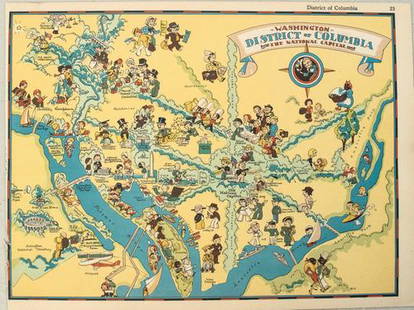
Sold20211938 R Taylor White Pictorial Map of Washington D.C. --Title: 1938 R Taylor White Pictorial Map of Washington D.C. -- Washington District of Columbia the National Capital Cartographer: Ruth Taylor White Year / Place: 1938, Boston Map Dimension (in.): 11.6See Sold Price
Sold2022Delaware Valley Chippendale Cherry Dressing TableSoutheastern Pennsylvania, Delaware, or Maryland, circa 1770, molded figured cherry top over three dovetailed drawers, deeply scalloped skirt centering a shell carved drop, shell carved cabriole legsSee Sold Price
3 days LeftJasper521880 Gray Map of Maryland, Delaware and Washington DC -- Maryland, Delaware and the District of$75
3 days LeftJasper521861 Mitchell Map of Washington DC -- Plan of the City of Washington The Capitol of the United$70
Jun 16Broward Auction GalleryJoseph Conover Claghorn (DC,MD,PA,1869-1947) watercolor painting antique$10
4 days LeftUniversity ArchivesFeb. 1777 Issue of The Gentleman's Magazine with Superb Map of Philadelphia$140(1 bid)
3 days LeftFleischer's Auctions1755 Map Partie de l'Amerique Septentrionale, qui comprend Le Cours de L'Ohio...$200(3 bids)


![Colton's Delaware/Maryland Map [Southern States]: Colton's Delaware and Maryland Map; Delaware on the right, Maryland on the left. J. H. Colton Cartographer. Published by J. H. Colton, New York. Insert of 'District of Columbia' lower left. Stamped 'E](https://p1.liveauctioneers.com/5755/154409/77936946_1_x.jpg?height=310&quality=70&version=1573094011)


![4 maps: Colonial US, Maryland, DC, Railroads: [Railroads/MD/DC] 4 Maps. ++ J.G. Langdon. MAP OF THE DISTRICT OF COLUMBIA 1901… FOR THE PREPARATION OF A PLAN FOR THE IMPROVEMENT OF THE PARK SYSTEM OF THE DISTRICT OF COLUMBIA. NO. D-99. Balt: A.](https://p1.liveauctioneers.com/179/85723/44107986_1_x.jpg?height=310&quality=70&version=1457208384)


![[LEUTZE, Emauel (1816-1868), artist]. Grant at the Capture ... (1 of 1)](https://p1.liveauctioneers.com/928/328184/176813677_1_x.jpg?height=282&quality=70&version=1714496988)

![[LINCOLN] 1876 Radical Republican Hayes Ballot (1 of 1)](https://p1.liveauctioneers.com/7226/322253/173251603_1_x.jpg?height=282&quality=70&version=1710004847)


