Sold2017WIT, Frederick de (1630-1706). [Composite Atlas].WIT, Frederick de (1630-1706). [Composite Atlas]. Amsterdam: F. de Wit, [n.d. ma circa 1680]. Bellissimo atlante composito con oltre 117 mappe di cui la maggior parte a doppia pagina e colorate all'epSee Sold Price
Sold2021Eleven Antique Maps of EuropeEleven Antique Maps of Europe , 16th-18th c., incl. Ptolemy from 1541 (4); a Blaeu map of "Regno di Napoli", Hondius map of the Holy Land, de Wit map of Southern Spain, an undated manuscript map of MeSee Sold Price
Sold2022MAP, South America, WitNorthwestern South America & Central America. Frederick de Wit, Novae Hispaniae, Chili, Peruviae, et Guatimalae Littorae, from Orbis Maritimus ofte Zee Atlas, 1680 (circa). Hand Color. This handsome sSee Sold Price
Sold2021[Blaeu, Willem]23. [Blaeu, Willem].The Atlas Blaeu - Van der Hem...Compiled by Peter van der Krogt & Erlend de Groot. Volume V (only). Africa, Asia and America,..2 volumes, including facsimile volume. Folio or 4to,See Sold Price
Sold2024Blaeu, pub. 1635 - Map of Romania: TransylvaniaThis remarkable, map with original hand-coloring is is Jan Blaeu's Le Theatre du Monde ou Nouvel Atlas Contenant, Les Chartes et Descriptions de tous les Pais de la Terre Mis en lumiere. This is fromSee Sold Price
2023Blaeu, pub. 1635 - Map of Scandinavia (Norway, Finland, Sweden)This remarkable, map with original hand-coloring is is Jan Blaeu's Le Theatre du Monde ou Nouvel Atlas Contenant, Les Chartes et Descriptions de tous les Pais de la Terre Mis en lumiere. This is fromSee Sold Price
Sold2022Visscher Atlas Minor AtlasVISSCHER, Nicolaes II (1649-1702). Atlas minor, sive geographia compendiosa qua orbis terrarum per paucas attamen novissimas tabulas Ostenditura. Amsterdam: Nicolaes Visscher, [ca 1689, or later]. ComSee Sold Price
Sold2017De Wit Portolan Sea Chart of EuropeTotius Europae Victoria... Frederic De Wit (1630-1706). Engraved map with original hand color. Amsterdam, 1675. 20 x 35 1/2 inches sheet, 27 1/2 x 43 inches framed. “The most striking and decorativeSee Sold Price
Sold2022De Wit - Nova Orbis Tabula In Lucem Edita, MapFrederick De Wit (circa 1629-1706), Nova Orbis Tabula In Lucem Edita, A.F. De Wit, published by Covens and Mortier, Amsterdam, circa 1720, in two sheets, engraving on laid paper, double hemisphere vieSee Sold Price
Sold2022De Wit, Map of North and South America, c. 1720Property of a Private Collector, Hilton Head Island, SC Description: Frederick De Wit (circa 1629-1706), Nova Orbis Tabula In Lucem Edita, A.F. De Wit, Amsterdam: Covens and Mortier, c. 1720, publSee Sold Price
Sold2023[MAP] DE WIT, F. NOVA ORBIS TABULA IN LUCEM EDITAde Wit, Frederik. NOVA ORBIS TABULA, IN LUCEM EDITA. (Amsterdam: circa 1670s.) Beautiful map in exquisite full handcolouring, with elaborate corner scenes illustrating the four seasons and the Zodiac,See Sold Price
Sold2022Theo de Wit, ArmchairTheo de Wit Armchair EMS OverschieThe Netherlands, c. 1935chrome-plated steel, plywood, lacquered plywood 29.5 h × 20 w × 19 d in (75 × 51 × 48 cm) TSee Sold Price
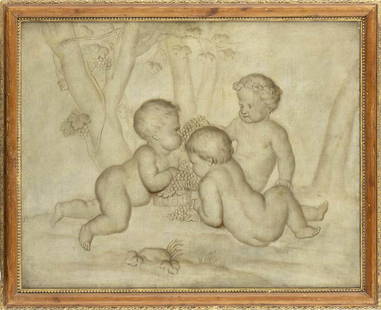
Sold2023JACOB DE WIT (Amsterdam, 1695-1754), ATTRIBUTED TOThree puttos with bunches of grapes Oil on canvas, cm. 65x82. FramedSee Sold Price
Sold2022Jean Paul de Wit (Belgium,1851-?) oil painting antiqueARTIST: Jean Paul de Wit (Belgian, 1851 - ???) NAME: Portrait of Woman MEDIUM: oil on canvas CONDITION: Some craquelure. Minor paint losses along edges. No visible inpaint under UV light. SIGHT SIZE:See Sold Price
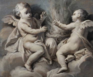
SoldJacob De Wit (Dutch, 1695-1754) A Flying Putto (framed 46.5 x 40.3 x 5.0 cm (18 5/16 x 15 7/8 x ...Jacob De Wit (Dutch, 1695-1754) A Flying Putto unsigned; attributed by Dr. A.W.F.M. Meij, (former) curator of Museum Boijmans-van Beuningen, Rotterdam (according to an inscription on the backing paperSee Sold Price
Sold2024EARLY 18TH C. DUTCH CHART OF PACIFIC OCEAN BY FREDERIK DE WIT (1629-1706) WITH CALIFORNIA AS AN"Magnuum Mare del Zur, cum Insula California, De Groote Zuyd-Zee en't Eylandt California; Gedruck't Amsterdam by Frederick De Wit ince Calver Street". Handcolored copper engraving. Engraver: Romeyn deSee Sold Price
Sold2019Attributed to Jacob de Wit (c.1695-1754) Dutch.Attributed to Jacob de Wit (c.1695-1754) Dutch. 'Allegory of Summer', en grisaille, Oil on Canvas, 7.75" x 9", and a companion piece, 'Putti with a Scythe and Hay', a Pair (2).See Sold Price
Sold2023North Pole, 'Polkarte'; Frederik De Wit (1610-1698) - "Poli Arctici, et circumiacentium terrarumArtis/Title: North Pole, 'Polkarte'; Frederik De Wit (1610-1698) - "Poli Arctici, et circumiacentium terrarum descriptio novissima" - 1661-1680 Date: 1670 Material: Paper Dimensions: 62 cm x 67 cm DesSee Sold Price
Sold20191662 deWit Map of Southeast Asia -- Tabula IndiaeReserve Reduced! Title/Content of Map: 1662 deWit Map of Southeast Asia -- Tabula Indiae Orientalis Date: 1662, Amsterdam Cartographer: F de Witt Size: 18 X 22.2 in. This is a outstanding larger map oSee Sold Price
Sold2018Allard Engraved Map of Iberian PeninsulaCorona Portugalliae cum ei affinibus Regnis Hispanicis...Carel Allard (1648-c. 1709). Engraved map with fine original hand color in full. Amsterdam: Frederick De Wit, c. 1705. In 4 parts, 21 1/8 x 24See Sold Price
Sold2016Biblia latinaBiblia latina (cum postillis Nicolai de Lyra et expositionibus Guillelmi Britonis in omnes prologos S. Hieronymi et additionibus Pauli Burgensis replicisque Matthiae Doering). Add: Nicolaus de Lyra: CSee Sold Price
Sold2015Magnum Mare del Zur cum InsulaCalifornia by Frederick de Wit (1630-1706), Amsterdam, 1675, copper-engraved mariner's chart, hand-colored in outline, showing California as an island, Tooley #40, with a colorful pictorial cartoucheSee Sold Price
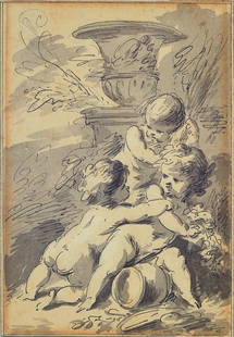
Sold2016Jacob de WittJacob de Wit, ca. 1695-1754, three cupids on agarden vase, pen and ink drawing on paper, signed on the back, about 18x12cm, under glass, frameSee Sold Price
Sold2015Tabula Indiae Orientalis byFrederick de Wit Amsterdam, 1662, de Wit's attractive hand-colored map of Southeast Asia, engraved by Joannas Lhulier, this map served as a prototype for Speed's map of the East Indies, cartouche withSee Sold Price
4 days LeftJasper521753 Robert de Vaugondy Map of Central France -- Gouvernemens Generaux De La Marche, Du Limosin Et$45
Jun 02Schilb Antiquarian Rare Books1698 Blaise PASCAL Provincial Letters Witchcraft Sorcery JESUIT Philosophy RARE$82(2 bids)
May 14Fleischer's Auctions1755 Map Partie de l'Amerique Septentrionale, qui comprend Le Cours de L'Ohio...$200(3 bids)
3 days LeftWinter Associates BOOK: Benjamin Franklin, "Mémoires De La Vie Privée Écrits Par Lui-Même, Et Adressées À Son$450
May 12Hoch LTD.Eighteen Silver Reference Books, Sterling Silver, American Silversmiths, Philadelphia, Maryland,$50(1 bid)
3 days LeftWinter Associates BOOKS: Two separate volumes of a historical dictionary or encyclopedia by Louis Moreri, including:$150
May 17Ni-Cola Classics - Automobilia Auction & Classic Car SalesBuch 27-parts about 'Le Mans' from the 50s-2010s€70


![WIT, Frederick de (1630-1706). [Composite Atlas].: WIT, Frederick de (1630-1706). [Composite Atlas]. Amsterdam: F. de Wit, [n.d. ma circa 1680]. Bellissimo atlante composito con oltre 117 mappe di cui la maggior parte a doppia pagina e colorate all'ep](https://p1.liveauctioneers.com/3662/102842/52581030_1_x.jpg?height=310&quality=70&version=1492593376)


![[Blaeu, Willem]: 23. [Blaeu, Willem].The Atlas Blaeu - Van der Hem...Compiled by Peter van der Krogt & Erlend de Groot. Volume V (only). Africa, Asia and America,..2 volumes, including facsimile volume. Folio or 4to,](https://p1.liveauctioneers.com/1352/192004/96768721_1_x.jpg?height=310&quality=70&version=1611259574)


![Visscher Atlas Minor Atlas: VISSCHER, Nicolaes II (1649-1702). Atlas minor, sive geographia compendiosa qua orbis terrarum per paucas attamen novissimas tabulas Ostenditura. Amsterdam: Nicolaes Visscher, [ca 1689, or later]. Com](https://p1.liveauctioneers.com/1968/250616/130196468_1_x.jpg?height=310&quality=70&version=1654190895)


![[MAP] DE WIT, F. NOVA ORBIS TABULA IN LUCEM EDITA: de Wit, Frederik. NOVA ORBIS TABULA, IN LUCEM EDITA. (Amsterdam: circa 1670s.) Beautiful map in exquisite full handcolouring, with elaborate corner scenes illustrating the four seasons and the Zodiac,](https://p1.liveauctioneers.com/8124/310027/165853624_1_x.jpg?height=310&quality=70&version=1700184289)