Sold20211835 Smith World Map -- A Chart Exhibiting the ActualTitle: 1835 Smith World Map -- A Chart Exhibiting the Actual and Comparative Size of each Country, Nation, or Kingdom; its Population as a Whole and to a Square Mile. Also the Different States of SociSee Sold Price
Sold2017Smith: Antique Map of the World, 1835Map: 1835 Smith World Map -- A Chart Exhibiting the Actual and Comparative Size of each Country, Nation, or Kingdom; its Population as a Whole and to a Square Mile. Also the Different States of SocietSee Sold Price
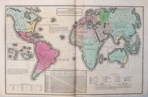
Sold2019Chart Exhibiting the Actual and Comparative Size ofTitle/Content of Map: Chart Exhibiting the Actual and Comparative Size of Each Country, Nation, Or Kingdom: Its Population As a Whole and to a Square Mile: Also the Different States of Society, FormsSee Sold Price
Sold20211821 Woodbridge Thematic World Map of Type ofTitle: 1821 Woodbridge Thematic World Map of Type of Inhabitation -- Chart of the Inhabited World Exhibiting the Prevailing Religion, form of Government, Degree of Civilization and Population... CartoSee Sold Price
Sold20191835 Hammond World Map -- The WorldTitle/Content of Map: 1835 Hammond World Map -- The World Cartographer: J Hammond Size: 11 x 17 in. A nice world map showing the Eastern and Western Hemispheres as well as polar projections and climatSee Sold Price
Sold2017Chart of the World on Mercators ProjectionCirca 1796 Lot of 2 Antique World Maps; Titles: "Chart of the World on Mercators Projection" (Doolittle, sculp.) Approximate size: 11" x 8-3/8". "Map of the World from the best Authorities" (DoolittleSee Sold Price
Sold2018Smith/Burgess: Antique Map of Africa, 1835Title/Content of Map: 1835 Smith/Burgess Map of Africa -- Africa Date Printed: 1835, Hartford Cartographer: C Smith / D Burgess Size: 8.7 x 10.4 in. This is a very nice map of Africa from the early 19See Sold Price
Sold20201855 Johnston World Map with Comperative Chart ofTitle/Content: 1855 Johnston World Map with Comperative Chart of Rivers and Mountains -- The World in Hemispheres, with Comparative Views of the Heights of ths Principal Mountains and Lengths of the PSee Sold Price
Sold2017Rand McNally: Antique World Map, Rivers & MountainsMap: Rand McNally World Map and Comperative Chart of Rivers and Mountains -- The World on Mercator's Projection [verso] Western Hemisphere Cartographer: Rand McNally Year / Place: 1898, Chicago Map DiSee Sold Price
Sold2024Henry Bostwick, 1827, bound atlas "A Historical,Chronological and genealogical Chart" exhibiting maps of "Ancient Countries, as well as a new scale of time charts" developed by Bostwick including countries in the Mediterranean, Greece, France, andSee Sold Price
Sold20201855 Smith’s ATLAS Geography 36 BEAUTIFUL Colored MAPS1855 Smith’s ATLAS Geography 36 BEAUTIFUL Colored MAPS World ‘Smith’s Atlas of Modern and Ancient Geography’ is a collection of maps focusing on the United States, but includes maps of the worSee Sold Price
Sold2020The Second World WarOne of the most comprehensive accounts of the Second World War. Contains maps, charts, copies of correspondence, lists of meeting and a vast array of relative information." Publishers black cloth withSee Sold Price
Sold20231821 Woodbridge Thematic World Map -- Moral and Political Chart Of The Inhabited World ...Title: 1821 Woodbridge Thematic World Map -- Moral and Political Chart Of The Inhabited World ... Cartographer: W. Woodbridge Year / Place: 1831, Hartford Map Dimension (in.): 8.2 X 10.8 in. This is aSee Sold Price
Sold20191859 Beeton Chronological Chart with World Map -- AnTitle/Content of Map: 1859 Beeton Chronological Chart with World Map -- An Historical Chronological Chart with inset of The World in Mercators Projection Date: 1859 c., London Cartographer: S Beeton SSee Sold Price
Sold20231758 Map Chart of World TradewindsAn Accurate Chart of the World with the New Discoveries....Tradewinds.., by Thomas Kitchin, 1758. Large folding map, measures 17 x 13", Condition issues including creasing and repaired breaks at foldsSee Sold Price
Sold2022AJ Nystrom 2-Sided Chalkboard School Map, US & WorldLarge AJ Nystrom Roll Up 2 Sided Chalkboard Classroom Map Chart, US & World. Wonderful chart has maps of the United States and the World outlined in yellow on a black chalkboard backing. From the RoyaSee Sold Price
Sold20211821 Woodbridge Thematic World Map -- Moral andTitle: 1821 Woodbridge Thematic World Map -- Moral and Political Chart Of The Inhabited World ... Cartographer: W. Woodbridge Year / Place: 1831, Hartford Map Dimension (in.): 8.2 X 10.8 in. This is aSee Sold Price
Sold20191821 Chart of the World Map This is a mercator'sThis is a mercator's projection of North America by John Purdy, published Jan 1, 1821 by Richard Holmes Laurie, measures 40" wide by 26.5" tall.See Sold Price
Sold2023Perry, Matthew 1856 Large Map. Chart of the World. Track of the U.S Steam Ships"Chart of the World showing the Track of the U. S. Steam Frigates Mississippi, Susquehanna, and Powhatan" Large Folio Lithograph Map Published 1856, Washington for "Narrative of the Expedition of an ASee Sold Price
Sold2023Thomson, John (Pub) 1825 Map. Chart of the WorldCopper Engraved Map Published 1825 by John Thomson, Edinburgh for "The Edinburgh School Atlas" by N. R. Hewitt. Maps Engraved by Hewitt. Original Outline Hand Colour. Rare. Paper Size: 10.5 x 8 inch (See Sold Price
Sold2021Thomson, John (Pub) 1825 Map. Chart of the WorldCopper Engraved Map Published 1825 by John Thomson, Edinburgh for "The Edinburgh School Atlas" by N. R. Hewitt. Maps Engraved by Hewitt. Engraved Vignette in corner. Original Outline Hand Colour. RareSee Sold Price
Sold2023Russell & Barclay 1832 Hand Col Map. Chart of the WorldHand Colored Steel Engraved Map Published 1823-40, by Fisher & Son, "A Complete Atlas of the World" by John Russell et al. A Very Rare Work which is compiled from the same plates used in different ediSee Sold Price
Sold2023Russell & Barclay C1825 Antique Map. Chart of the World (On Mercator Proj.)Copper Engraved Map Published C1825., by Fisher & Son, "A Complete Atlas of the World" by John Russell et al. The companion Atlas to "A Complete and Universal English Dictionary" by James Barclay. PapSee Sold Price
Sold2019Chart of the World, On Mercators ProjectionTitle/Content of Map: Chart of the World, On Mercators Projection Date: 1815 ca. Cartographer: WYLD/HEWETT Size: 11.4Height - 17.4Width Publisher: JOHN THOMPSON & CO. Only named place in Mid-MississipSee Sold Price
4 days LeftJasper52Bahamas harbours Pelican Abaco Berry I Jumentos ADMIRALTY chart 1899 (1920) map$140
May 16Zikorn Arts & History ObjectsCentral America West Coast 1855 British Admiralty Nautical Chart$100(1 bid)
4 days LeftHunt and Peck Estate Services, Inc.William Hole "A Description of the land of Gosen, and Moses passage though the Deserts"$50
4 days LeftHunt and Peck Estate Services, Inc.Chart Of The World According To Mercators Projection Showing Tracks & Discoveries Of Capt. Cook$140
4 days LeftHunt and Peck Estate Services, Inc.1849 Alex Mackay 1st US Ed. 2 Vol. "The Western World or Travels in the United States in 1846-1847"$50
Featured4 days LeftJasper52The Bahamas, Cuba & Bermuda "or Summer Islands". THOMSON 1817 old antique map$180
4 days LeftJasper52Central America Caribbean Gulf of Mexico chart Ports lighthouses LARGE 1918 map$45


![Rand McNally: Antique World Map, Rivers & Mountains: Map: Rand McNally World Map and Comperative Chart of Rivers and Mountains -- The World on Mercator's Projection [verso] Western Hemisphere Cartographer: Rand McNally Year / Place: 1898, Chicago Map Di](https://p1.liveauctioneers.com/5584/108569/55677982_1_x.jpg?height=310&quality=70&version=1504123318)


