Sold2020Antique Map (18th Century)DOMINIUM VENETUM, 1729, hand-colored double page atlas engraving, engraved by G. Mattheus Seutter Jr., image 19 ½ x 22 ¾”, sheet 21 x 23 ¾”.See Sold Price
Sold2020Antique Map (18th Century)IMPERII MAGNI MOGOLIS SIVE INDICI PADSCHACH, hand-colored double-page atlas engraving, engraved by Albrecht Carl Seutter, sheet 19 ½ x 22 ½”.See Sold Price
Sold2023Two Antique Hand Colored Batty Langley Botanical PrintsTwo antique early 18thC. double-page hand colored prints by Batty Langley. Both prints depict grape species, one depicts the White Raifin Grape the other print depicts both Parfley and Chryftal GrapeSee Sold Price
Sold2022(2) 18th c. road maps, London-Norwich, etc.Two hand colored maps of roads from London to Norwich, England, and from Shrewsbury to Holywell, England. A printed description in an attached envelope on the back of one states that they were made bySee Sold Price
Sold2023"Regni Daniae" Antique 18thC Hand Colored Map of Denmark by Johann Baptiste Homann"Regni Daniae" Antique 18thC Hand Colored Map of Denmark by Johann Baptiste Homann. Frame Size: 21 3/4" H x 25 1/4" W x .75" D. Sight Size: 20" H x 23 1/2" W.See Sold Price
Sold20222 E. Bowen Maps of Italy & GreeceEmanuel Bowen, Welsh, 1694-1767. Two 18th century hand-colored engraved maps. Includes one titled "Middle or Proper Italy" and another titled "A Map of Great Greece and the Islands of Sardinia and CorSee Sold Price
Sold20222 Antique Maps of Saltzberg & Swiss AlpsTwo 18th century hand-colored engraved maps. Includes one titled "Saltzberg" by Gabriel Bodenehr and another titled "La Descente du Cote du Midi des Alpes" (The Descent on the South Side of the Alps)See Sold Price
Sold2023Antique Map of HispaniolaAntique Map of Hispaniola, "Hispaniolae, Cubae...", Ortelius, late 17th/early 18th c., hand-colored engraved map, sight 15 in. x 21 1/2 in., framedSee Sold Price
Sold2023Rare 19thc Costume Plates, Late 18thc Women's DressesRare 19th Century costume plates, double-page book plate, hand-colored engravings from a German book, "Zur Geschichte Der Costume". Depicts women of the middle class, dresses of the late 18th CenturySee Sold Price
Sold2016*ZATTA, ANTONIO(18th C. Italian) Handcolored engraved map illustrating Maryland, Jersey, Delaware, Virginia and Carolina settlements, approximate plate size 13 1/4" x 17 1/2", frame 16" x 22 1/2".See Sold Price
Sold2018WALKER, John and Charles.WALKER, John and Charles. Hobson's Fox-Hunting Atlas. London: J. and C. Walker, [ca 1868-1871]. Folio (368 x 242 mm). 42 engraved or lithographic double-page maps hand-colored in outline, hunts stampeSee Sold Price
Sold2022ANTIQUARIAN GERMAN WORLD ATLAS,ANTIQUARIAN GERMAN WORLD ATLAS, H. Kiepert, C.F. Weiland, C. Graf, Allgemeiner Hand-Atlas der Erde und des Himmels, comprising 70 copper-plate engraved double-page maps hand-colored in outline, maps dSee Sold Price
Sold2022(CLEVELAND.) G.M. Hopkins. Plat Book of the City of Cleveland. Volumes 2, 3, & 4.(CLEVELAND.) G.M. Hopkins. Plat Book of the City of Cleveland. Volumes 2, 3, & 4. 37 hand-colored double-page lithographed maps (including index); 45 hand-colored double-page lithographed maps (includSee Sold Price
Sold2021Map of City and Harbour of MacauA Plan of the City and Harbour of Macao" engraved by B. Baker, Islington 27" x 20 1/2" (sight) hand-colored engraved map 18th century framed- 32 1/2" x 40See Sold Price
Sold2018Janssonius Joannes Nova Belgica Et Anglia Nova doubleJanssonius Joannes Nova Belgica Et Anglia Nova double page engraved map, hand colored, ss 15 1/2" x 20"See Sold Price
Sold2021"Terra FIrma and Caribbe Islands", Emanuel Bowen"A New and Accurate Map of the Terra Firma and the Caribbe Islands", an 18th century map by Emanuel Bowen (1693-1767). An engraved and hand colored map in two pages with central fold crease, framed. 1See Sold Price
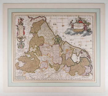
Sold2020Visscher, Claes .Germaniæ Inferioris XVIIVisscher, Claes .Germanie Inferioris XVII Provinciarum. Fine hand colored engraved double-page map. 18-1/2 x 22-1/2 inches plus margins, blank on verso, neatly matted; some browning, generally sound.See Sold Price
Sold2021WEST AFRICA; ABYSSINIA: SUDAN, ETHIOPIA,AND ERITREA. ABRAHAM ORTELIUS (1527-1598)Presbiteri Iohannis, Sive, Abissinorum Imperii Descriptio. Antwerp: Ortelius, c. 1600. Double page copper-plate engraved map on laid paper, hand-colored, textSee Sold Price
Sold2023WILLEM BLAEU (1571-1638) MAP of NORMANDIADouble-page engraved map with hand-colored highlights and printed on heavy laid paper 18 3/4 x 23 inches. framed 21 1/2 x 27 inches (overall)See Sold Price
Sold2022Group of 11 Antique Maps11 maps, variously places in Europe, etc., published by Vicenzo Passini Carli, Sienna, Italy, late 18th Century. Hand-colored engravings. 15 3/4" x 11 1/2".See Sold Price
Sold20231700s MAP of ASIA MINOR ARMENIA SYRIA SYCILY PERSIA antiqueMap of Asia Minor early 18th century hand colored Size 14 1/2 by 18 3/4" Very good condition Reserve: $160.00 Shipping: Domestic: Flat-rate of $25.00 to anywhere within the contiguous U.S. InternaSee Sold Price
Sold2023Benjamin Cole, Map of Wards of LondonBenjamin Cole (English, 1695-1766), 18th century hand-colored engraving depicting the Baynards Castle Ward and Farringdon Ward, 14 1/2" x 18 1/2" sight size, 23 3/4" x 27 3/4" framed.See Sold Price
Sold2022(NEW YORK CITY.) G. W. Bromley & Co. Atlas of the City of New York - Borough of Manhattan. Volumes 2(NEW YORK CITY.) G. W. Bromley & Co. Atlas of the City of New York - Borough of Manhattan. Volumes 2 and 3. Volume 2, 14th Street to 59th Street: Index map and 45 hand-colored double-page lithographedSee Sold Price
Sold2020Hand Colored Engraving of a Nautilus Shell on 18thHand Colored Engraving of a Nautilus Shell on 18th Century Ledger Page, Image Size 12 x 8 Inches, Framed and Glazed 18 1/2 x 14 1/2 InchesSee Sold Price
May 09Hunt and Peck Estate Services, Inc.ANTONIO ZATTA (ITALIAN, 18TH CENTURY) MAP OF VIRGINIA$70(1 bid)
May 10New England Auctions - Fred GiampietroPair of York and Lancaster Bas-Relief Carvings$125(2 bids)
1 day LeftJeffrey S. Evans & AssociatesJOHN DADLEY (ENGLISH, 1767-1817) AFTER PU-QUA (CHINESE, 18TH CENTURY) "THE COSTUME OF CHINA" PRINTS,$100
Bonhams[ALCHEMY] ROSICRUCIAN ALCHEMICAL MANUSCRIPT. MYSTERIUM MAGNUM. Illustrated alchemical manuscript...$22,000
May 05Global Auctions CompanyAntique Silverplate Meriden B. Company Rogers Bros Box hand chased scene c1915$100
May 05Global Auctions Company12pc Cased Cailar Bayard Silverplate fish dessert fork set in presentation box$70
May 14Fleischer's Auctions1755 Map Partie de l'Amerique Septentrionale, qui comprend Le Cours de L'Ohio...$200(3 bids)
5 days LeftAdam's AuctioneersCAREY'S General Atlas Improved and Enlarged, being a Collection of Maps of the World and Quarters,€2,200(2 bids)


![WALKER, John and Charles.: WALKER, John and Charles. Hobson's Fox-Hunting Atlas. London: J. and C. Walker, [ca 1868-1871]. Folio (368 x 242 mm). 42 engraved or lithographic double-page maps hand-colored in outline, hunts stampe](https://p1.liveauctioneers.com/197/119933/61100797_1_x.jpg?height=310&quality=70&version=1522758048)


![[ALCHEMY] ROSICRUCIAN ALCHEMICAL MANUSCRIPT. MYSTERIUM MAGNUM. Illustrated alchemical manuscript... (1 of 6)](https://p1.liveauctioneers.com/1043/325155/176458550_1_x.jpg?height=282&quality=70&version=1714118631)


