Sold2023PACIFIC OCEAN Sandwich Islands/Hawaii Australia New Zealand &c. WELLER 1863 mapTITLE/CONTENT OF MAP: 'The Pacific Ocean' DATE PRINTED: 1863 IMAGE SIZE: Approx 47.0 x 65.0cm, 18.5 x 25.75 inches (Large); Please note that this is a folding map. TYPE: Antique map with original outlSee Sold Price
Sold2018PACIFIC OCEAN Sandwich Islands/Hawaii Australia NewReserve Reduced! TITLE/CONTENT OF MAP: 'The Pacific Ocean' DATE: 1863 IMAGE SIZE: Approx 47.0 x 65.0cm, 18.5 x 25.75 inches (Large); Please note that this is a folding map. TYPE: Antique map with origSee Sold Price
Sold2017Weller: Map of Pacific, Hawaii Australia New ZealandTITLE/CONTENT OF MAP: 'The Pacific Ocean'. Sandwich Islands/Hawaii Australia New Zealand This map is folding hence the centrefold line may show on the image below DATE PRINTED: 1862 IMAGE SIZE: ApproxSee Sold Price
Sold2016Hawaiian & Pacific Polynesian Islands, Australia, 1850Original engraving by Samuel Augustus Mitchell from Mitchell’s Universal Atlas, 1850. Map highlights the Pacific ocean & surrounding islands; Hawaii, Polynesian, Australia & New Zealand. Dimensions:See Sold Price
Sold2023PACIFIC OCEAN. Australia New Zealand Polynesia Micronesia. BLACKIE 1893 mapTITLE/CONTENT OF MAP: 'The Pacific Ocean, general map' DATE PRINTED: 1893 IMAGE SIZE: Approx 35.0 x 51.5cm, 13.75 x 20.25 inches (Large); Please note that this is a folding map. TYPE: Colour Antique mSee Sold Price
Sold2018Pacific OceanTitle/Content of Map: Pacific Ocean Date Printed: 1840-05-15 Cartographer: WALKER, J. & C. Size: 12.2X15.5 Details from the Aleutian Island to Australia/New Zealand and to Cape Horn/South America. DetSee Sold Price
Sold2022Kelly, Christopher 1816 Map. Pacific Ocean. AustraliaCopper Engraved Map Published 1816, London for "A New and Complete System of Universal Geography" by Christopher Kelly. Maps Engraved by Findlay, Wallis and others. Paper Size: 10 x 8 inch (26 x 21cm)See Sold Price
Sold2018Pacific OceanReserve Reduced! Title/Content of Map: Pacific OceanDate: 1835 Cartographer: BRADFORD, THOMAS GAMALIEL Material/Medium: AMERICAN STATIONERS COMPANY Size: 7.75 x 10 inches Australia called New Holland.See Sold Price
Sold2018Reclus, Elisee C1880 Lot of 28 Wood Eng Maps, GoodIncl Australia, Tasmania, New Zealand, Philippines, Reunion, Madeira, Madagascar, Indian & Pacific Ocean. Wood Engraved Maps with surrounding and verso text. Published 1875-94, Paris for "La NouvelleSee Sold Price
Sold2018POLYNESIA/PACIFIC ISLANDS. inc Sandwich/HawaiianTITLE/CONTENT OF MAP: 'Polynesia or Islands in the Pacific Ocean' Vignettes: Resolution Bay, Marquesas; Harbour of Dory, New Guinea; Otaheite [Tahiti]; Kalakakooa, Sandwich Islands [Hawaiian islands].See Sold Price
Sold2023POLYNESIA/PACIFIC ISLANDS. inc Sandwich/Hawaiian islands. RAPKIN/TALLIS 1851 mapCAPTION PRINTED BELOW PICTURE: 'Polynesia or Islands in the Pacific Ocean' Vignettes: Resolution Bay, Marquesas; Harbour of Dory, New Guinea; Otaheite [Tahiti]; Kalakakooa, Sandwich Islands [HawaiianSee Sold Price
2018POLYNESIA/PACIFIC ISLANDS. inc Sandwich/HawaiianReserve Reduced! TITLE/CONTENT OF MAP: 'Polynesia or Islands in the Pacific Ocean' Vignettes: Resolution Bay, Marquesas; Harbour of Dory, New Guinea; Otaheite [Tahiti]; Kalakakooa, Sandwich Islands [HSee Sold Price
Sold2021[Pacific Islands] Oceanic Steamship Co. Playing Cards.[Pacific Islands] Oceanic Steamship Co. Playing Cards. San Francisco, ca. 1920. 52 + J + EC + OB. Joker advertises the ocean liner’s service to Hawaii, Samoa, Tahiti, New Zealand, Australia, andSee Sold Price
Sold20211888 Isles of Pacific Ocean New Zealand Fiji Tahiti1888 Isles of Pacific Ocean New Zealand Fiji Tahiti Easter Island Moai Hawaii “The Isles of the Pacific” is a late 19th-century history of the geography and wonders of the islands in the South PacSee Sold Price
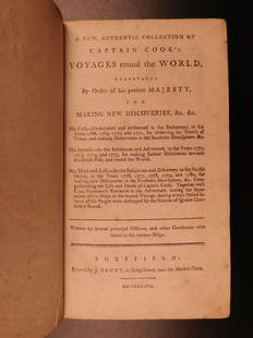
Sold20191786 VERY RARE Voyages of Captain James Cook Hawaii1786 VERY RARE Voyages of Captain James Cook Hawaii Pacific Australia New Zealand “Remember, the greater the opportunity, the fewer are those who see it.” – James Cook James Cook was an 18th-cenSee Sold Price
Sold2019Three Maps by the Hydrographic Office U. S. Navy,Three Maps by the Hydrographic Office U. S. Navy, consisting of "South Pacific Ocean, New Caledonia, New Caledonia Isle of Pines to Ven Island," 1921, H. - 42 in., W. -29 in.; with "South Pacific OceaSee Sold Price
Sold20201899 Map of the Pacific Ocean and AustraliaAuthor: Miller Title: 1899 Map of the Pacific Ocean and Australia Medium: Ink on Paper Dimensions: 16"X11" Map of the Pacific Ocean and Australia dated 1899. Published by J. Martin Miller and CompanySee Sold Price
Sold2018Indian Ocean Map 1941Indian Ocean Map : Australia, New Zealand and Malaysia. National Geographic magazine. Date: 1941. Editor: Gilbert Grosvenor. Measurement approximate: 25 x 32. Shipping cost: $15.00 excluding Hawaii, ASee Sold Price
Sold2018Tanner: Antique Map of Australia & Pacific Ocean, 1843Title/Content of Map: Australia and Pacific Ocean by Tanner Date Printed: 1843 Cartographer: H.C. Tanner Material/Medium: Paper Size: 17" x 14" Hand colored engraved Map based on the work of H.C. TannSee Sold Price
Sold2019Thomson: Southern HemisphereA fascinating southern hemisphere focused on the "Antarctic Ocean" and encompasing Australia, New Zealand and all of Oceania, from Thomson's influential New General Atlas. Thomson; Edinburgh / 1816/18See Sold Price
Sold2018Lapie: Antique Map of Australia & Pacific Islands, 1829Title/Content of Map: Australia & Pacific Ocean Islands Date Printed: 1829 Cartographer: A.E. Lapie Material/Medium: Paper Size: 17 1/2" x 23 1/2" Hand colored. Published in Paris. Pierre M. Lapie (17See Sold Price
Sold2022Binder Australia New Zealand & Pacific Island CoinsBinder Australia New Zealand & Pacific Island Coins. Approx 213 coins. 10 marked silverSee Sold Price
Sold20241856 Australia and Pacific Ocean Map with Hawaii Insert by MitchellTitle: 1856 Australia and Pacific Ocean Map with Hawaii Insert by Mitchell Date/Period: 1856 Materials: Hand colored steel engraving Size: 11” x 9” Discover Australia and the Pacific OceanSee Sold Price
Jun 02Schilb Antiquarian Rare Books1880 Captain James Cook Voyages Hawaii Pacific Australia Kippis South Sea Navy$1
7 days LeftHunt and Peck Estate Services, Inc.1784 Captain James Cook "A Voyage to the Pacific Ocean" 2 of 3 volumes$360(2 bids)
3 days LeftChurchill GalleriesCHART: South Pacific Ocean / SOCIETY ISLANDS - WESTERN GROUP/ HUAHINE TO MAUPITI With the$10
May 18RbfineartsVintage Signed "Milo" Bronze Aboriginal Hunter Sculpture, Possibly Max Milo (1938-1976)$80
May 10Rail & Road AuctionsFramed William J. Aylward Steamship New York Ocean Liner Lithograph Advertising Print$30
2 days LeftTrillium Antique Prints & Rare BooksCarey, pub. 1814 - Map of the East Indies with India, China, & New Holland (Australia)$50(1 bid)


![POLYNESIA/PACIFIC ISLANDS. inc Sandwich/Hawaiian: TITLE/CONTENT OF MAP: 'Polynesia or Islands in the Pacific Ocean' Vignettes: Resolution Bay, Marquesas; Harbour of Dory, New Guinea; Otaheite [Tahiti]; Kalakakooa, Sandwich Islands [Hawaiian islands].](https://p1.liveauctioneers.com/5584/128489/65352606_1_x.jpg?height=310&quality=70&version=1538523113)
![POLYNESIA/PACIFIC ISLANDS. inc Sandwich/Hawaiian islands. RAPKIN/TALLIS 1851 map: CAPTION PRINTED BELOW PICTURE: 'Polynesia or Islands in the Pacific Ocean' Vignettes: Resolution Bay, Marquesas; Harbour of Dory, New Guinea; Otaheite [Tahiti]; Kalakakooa, Sandwich Islands [Hawaiian](https://p1.liveauctioneers.com/5584/298779/159029476_1_x.jpg?height=310&quality=70&version=1692132475)
![POLYNESIA/PACIFIC ISLANDS. inc Sandwich/Hawaiian: Reserve Reduced! TITLE/CONTENT OF MAP: 'Polynesia or Islands in the Pacific Ocean' Vignettes: Resolution Bay, Marquesas; Harbour of Dory, New Guinea; Otaheite [Tahiti]; Kalakakooa, Sandwich Islands [H](https://p1.liveauctioneers.com/5584/129679/65959649_1_x.jpg?height=310&quality=70&version=1540338370)
![[Pacific Islands] Oceanic Steamship Co. Playing Cards.: [Pacific Islands] Oceanic Steamship Co. Playing Cards. San Francisco, ca. 1920. 52 + J + EC + OB. Joker advertises the ocean liner’s service to Hawaii, Samoa, Tahiti, New Zealand, Australia, and](https://p1.liveauctioneers.com/928/188932/95239653_1_x.jpg?height=310&quality=70&version=1609352044)