Sold2015Sébastien Le Prestre, marquis de VAUBAN - Nouveau traitSébastien Le Prestre, marquis de VAUBAN - Nouveau traité de géométrie et fortification où est enseigné la nouvelle méthode, dont l'on se sert aujourd'hui en Allemagne, Espagne, Italie, HollandeSee Sold Price
Sold2023MAPS IN BOOK, France, Le RougeIncludes Plans of New Orleans and Quebec. France, Atlases. Le Rouge, Recueil des Fortifications Forts et Ports de Mer de France Lave au Pinceau, 1760 (circa). Black & White. This book contains 89 platSee Sold Price
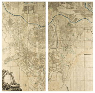
Sold2021Plan de Jedo'. Tokyo antique town city plan. Japan.TITLE/CONTENT OF MAP: 'Plan de Jedo, A.Palais de l'Empereur B.Niponbas ou le pont de l'Empereur [Plan of Tokyo]' The top image on the right hand side shows the entire map. To view a close up of the maSee Sold Price
Sold2020c1705 Engraved Plan Le Combat De SteenkerkeEngraved military plan entitled "Le Combat De Steenkerke" , engraved by Nicholas de Fer circa 1705, Belgium. Fine, measures 15 x 10.5" Reserve: $30.00 Shipping: Domestic: Flat-rate of $5.00 to anywherSee Sold Price
Sold2021[MAPS] SÉBASTIEN DE PONTAULT, CHEVALIER DE[MAPS] SÉBASTIEN DE PONTAULT, CHEVALIER DE BEAULIEU. Plan de la Ville, et Chateau de Valence... Paris: circa 1690. 17 1/2 x 21 inches, hand-colored engraving. Usual folds, generally a clean exampSee Sold Price
Sold2020Le Plan en Perspective de la Ville de Paris"Le Plan en Perspective de la Ville de Paris" after the 1734-1739 map by Louis Bretes and Claude Lucas, large facsimile engraving mounted on board and framed. sight 60-1/2" x 78", framed 67-3/4" x 85"See Sold Price
Sold20181705 Coquat Plan of the Battle of Fribourg during theTitle/Content of Map: 1705 Coquat Plan of the Battle of Fribourg during the 30 Yr.'s War -- Plan des combats de Fribourg Donnés le 3, le 5 et le 9 d'Aoust 1644... Date Printed: 1705 c., Paris CartogrSee Sold Price
Sold2020Georges Louis Rouge Plan of Paris Map 1765Georges-Louis Le Rouge (ca. 1712-1780), "Plan de Paris et de ses faubourgs en l'état qu'il étoit en 1765." This attractive map features the city of Paris along with points of interest. DimensionSee Sold Price
Sold2022SARTINE, ANTOINE DE Plan de l'île d'Amelia à la côte de la Floride orientale,SARTINE, ANTOINE DE Plan de l'île d'Amelia à la côte de la Floride orientale, tiré de la carte de la Georgie et de la Caroline méridionale de De Brahm, et assujeti pour le porSee Sold Price
Sold20171764 Map of Port At St. Vincent BellinCopper Plate Engraved Map “plan Du Port Et Du Carenage De Cariacoua Situe Dans La Partie Du Sud De L'isle De St. Vincent”, Bellin's "le Petit Atlas Maritime, Ou Recueil De Cartes Et De Plans Des QSee Sold Price
Sold2018FRENCH 18TH CENTURY MAP OF BOSTON, MASSACHUSETTSFRENCH 18TH CENTURY MAP OF BOSTON, MASSACHUSETTS, on laid paper, title in top center "PLAN DE BOSTON", most likely Georges-Louis Le Rouge (French, c. 1712 to 1790), probably after John Bonner (EnglishSee Sold Price
Sold2015Plan of the Battle of Vienna September 12, 1683. PolandPlan of the Battle of Vienna September 12, 1683. Poland. 1839.Print of steel engraving titled „Plan de la Bataille de Vienne livrie le 12 Septembre 1683“.Author unknown.Engraved by Bigant.From PORSee Sold Price
Sold20221638 SIEGE DE LA VILLE DE DOLE ANTIQUE VELLUM BINDING ILLUSTRATED w/ PLANSBoyvin, Jean. Le Siege de la Ville de Dole: capitale de la Franche-Comte et son hereuse deliverance ... Antwerp, 1638 pictorial engraved title, folded pictorial plan, approbation leaf; Original vellumSee Sold Price
Sold2020c1750 Three Engravings Dutch Military Plans AthThree engravings of Dutch military plans circa 1750, to of Ath and one showing "Le Combat De Steenkerke". Fine, each approx 16 x 11". Reserve: $40.00 Shipping: Domestic: Flat-rate of $5.00 to anywhereSee Sold Price
Sold20151737 Vauban on Fortifications and Mines Numerous Plates"De l`attaque et de la defense das places...", by Sebastian Vauban, printed by Den Haag - La Haye, Pierre de Hondt, 1737. 216 pages containing 34 of the 36 folding plates as called for (lacking platesSee Sold Price
Sold20201705 deFer Map of London -- Plan des Villes de LondresTitle/Content of Map: 1705 deFer Map of London -- Plan des Villes de Londres et de Westminster et de leurs Faubourgs avec le Bourg de Southwark Date: 1705, Paris Cartographer: N deFerSize: 8.7 X 13.1See Sold Price
Sold2016[BELGIQUE] Ottmar ELLIGER - Plan des lignes et campemen[BELGIQUE] Ottmar ELLIGER - Plan des lignes et campements des armées des alliez commandées par le roy de la Grande Bretagne devant la ville et chateau de Namur. A Amsteldam, Chez Nicolas VisscheSee Sold Price
Sold2017Dela Haye: Plan de la Baye de l'Acul (Haiti), 1787Map: Plan de la Baye de l'Acul; Baye de Dame-Marie; Le Port François; Plan du Môle St. Nicolas; Baye des Irois Cartographer: Dela Haye / Dépôt de la Marine Place & Date: Paris / 1787 Size: 17 1/2"See Sold Price
Sold2017Bellin: Plan De L’Isle a Vache, 1764“Plan De L’Isle a Vache a la Coste du Sud de S. Domingue”, by J.N. Bellin, 1764 from “Le Petit Atlas Maritime…”. Fine, tinting, in matting and tagged to top margin, measures 9 x 12”. PleSee Sold Price
Sold2022SARTINE, ANTOINE DE Carte d'une partie des côtes de la Floride et de la Louisiane, contenant leSARTINE, ANTOINE DE Carte d'une partie des côtes de la Floride et de la Louisiane, contenant le cours du Mississipi, depuis ses... [Paris: Dépôt des Cartes et Plans de la Marine], 1778.See Sold Price
Sold2015The ship with crew by Liou-chou. China. 1834.Print of steel engraving titled „Janque de Liou-tcheou portant le Tribut“.Author Jules Sébastien César Dumont d'Urville.Engraved by Beyer.From „Voyage pittoresque Autour du Monde, resume generSee Sold Price
Sold2018Austria.- Grimm (Maximilian von) Grundriss der Kl: Kl:Austria.- Grimm (Maximilian von) Grundriss der Kl: Kl: Haupt und Residenzstadt Wien mit ihren Vorstadten nach den Neuen Hausnumern 1797 / Plan de la Ville de Vienne et de ses Fouxbourgs avec le DenombSee Sold Price
Sold2021Jacques Nicolas Bellin MapsJacques Nicolas Bellin , "Plan de La Nouvelle Orleans" and "Carte des Embouchures du Mississipi", two hand-colored engraved maps, from Le Petit Atlas Maritime, 1764, 7 1/2 in. x 11 in., framed . ProveSee Sold Price
Sold2017MICHEL CHEVALIER (FRENCH, 19TH CENTURY) MAP OF THE C &MICHEL CHEVALIER (FRENCH, 19TH CENTURY) MAP OF THE C & O CANAL lithograph on paper, "Plan Topographique Du Terrain Traverse Par Le Canal de la Chesapeake a l'Ohio", with inset plan of Philadelphia, frSee Sold Price
7 days LeftJasper521804 TRAVELS of Ledyard & Lucas in Africa antique w/ MAPS Voyages de MM. Lédyard$240
May 16Zikorn Arts & History ObjectsCapture of Turkish Ships near Tétoüan by French Navy 1643 Etching$300(1 bid)
3 days LeftWorthington Galleries19th c. French Etching Coquelin dans le r?le de Tabourin (Tabarin) [in Paul Ferrier's Tabarin (1871)$25
6 days LeftFleischer's Auctions1755 Map Partie de l'Amerique Septentrionale, qui comprend Le Cours de L'Ohio...$150(2 bids)
May 16Freeman's | HindmanYvonne Canu (French, 1921-2007) Lavandières dans le village de Provence, 1987$3,000
May 16Freeman's | HindmanGeorges Charles Robin (French, 1903–2003) Le village de Carannac sur la Dordogne$1,000
BonhamsPablo Picasso (Spanish, 1881-1973); Le cirque de la vie observe, par une petite fille, number 14...$1,000(1 bid)
May 16Potter & Potter AuctionsBENEVOL (Luigi Maria Benevolo). Le Coupeur de Têtes. Paris:...$200
May 16Potter & Potter AuctionsD’APRES ROGER, Theo. Compteur O.S. / Le Compas de la Route....$600
3 days LeftArt Legacy AuctionsSalvador Dali Le Singe et le Leopard from Fables of Fontaine (Le Bestiare de la Fontaine Dalinise)$1,550


![Plan de Jedo'. Tokyo antique town city plan. Japan.: TITLE/CONTENT OF MAP: 'Plan de Jedo, A.Palais de l'Empereur B.Niponbas ou le pont de l'Empereur [Plan of Tokyo]' The top image on the right hand side shows the entire map. To view a close up of the ma](https://p1.liveauctioneers.com/5584/192167/96862305_1_x.jpg?height=310&quality=70&version=1611703298)

![[MAPS] SÉBASTIEN DE PONTAULT, CHEVALIER DE: [MAPS] SÉBASTIEN DE PONTAULT, CHEVALIER DE BEAULIEU. Plan de la Ville, et Chateau de Valence... Paris: circa 1690. 17 1/2 x 21 inches, hand-colored engraving. Usual folds, generally a clean examp](https://p1.liveauctioneers.com/292/204169/103522320_1_x.jpg?height=310&quality=70&version=1621026354)


![[BELGIQUE] Ottmar ELLIGER - Plan des lignes et campemen: [BELGIQUE] Ottmar ELLIGER - Plan des lignes et campements des armées des alliez commandées par le roy de la Grande Bretagne devant la ville et chateau de Namur. A Amsteldam, Chez Nicolas Vissche](https://p1.liveauctioneers.com/828/93130/47639054_1_x.jpg?height=310&quality=70&version=1472918018)


![SARTINE, ANTOINE DE Carte d'une partie des côtes de la Floride et de la Louisiane, contenant le: SARTINE, ANTOINE DE Carte d'une partie des côtes de la Floride et de la Louisiane, contenant le cours du Mississipi, depuis ses... [Paris: Dépôt des Cartes et Plans de la Marine], 1778.](https://p1.liveauctioneers.com/292/250642/130213716_1_x.jpg?height=310&quality=70&version=1654271664)