Sold2016Early Sea Chart for Triangulating. Johannes KeulenNiure Pascaart Van de Zekkusten Van Bretagne en Poictou...; Early sea chart for triangulating locations. Maker: Keulen, Johannes. Cartographer: C.J. Vooght. Origin: Amsterdam, 1697-1709. Sheet size: 2See Sold Price
Sold2018Cape Verde.- Doncker (Henrick) Pas-Caart vande SouteCape Verde.- Doncker (Henrick) Pas-Caart vande Soute Eylanden ofte Ilhas de Cabo Verde, sea chart of the Cape Verde Islands, with the Island Del Fuogo's erupting volcano, with strap-work title cartoucSee Sold Price
Sold2022KEULEN, JOHANNES VAN Pas kaart Van de Boght van Florida Met de Canaal Tusschen Florida en Cuba Door.KEULEN, JOHANNES VAN Pas kaart Van de Boght van Florida Met de Canaal Tusschen Florida en Cuba Door. Amsterdam: Gerard Van Keulen, [1734]. Fifth state. Engraved map, hand colored, framed; sheet measurSee Sold Price
2017van Keulen: Antique Sea Chart of South Hispaniola, 1682Map: Pas-kaart Van de Zuyd-Kust van Espanjola Cartographer: van Keulen Place & Date: Amsterdam / 1682 Size: 23" x 20" Condition: outline color (wash in cartouche); top margin trimmed close; light overSee Sold Price
Sold2021Johannes van Keulen (Dutch, 1654-1715)Johannes van Keulen (Dutch, 1654-1715) , "Pas kaart van de Noord Kust van Espaniola met d Eylanden daar Benoorden", Amsterdam, 1684, hand-colored engraved sea-chart, with inset maps of Tortuga and PorSee Sold Price
Sold2022Faroe Islands.- North Atlantic.- Keulen (Gerard van) Nieuwe afteekening van de Eylanden van Fero,Faroe Islands.- North Atlantic.- Keulen (Gerard van) Nieuwe afteekening van de Eylanden van Fero, scarce sea chart of the Faroe Islands with north oriented to the right, rhumb lines, compass roses, soSee Sold Price
Sold2023Van Keulen map of the Chesapeake Bay AreaVAN KEULEN, Johannes (1654-1715). Pas Kaart van de Zee Kuysten van Virginia. Engraved map with original hand color in part. Amsterdam, circa 1695. 20 3/4” x 24” sheet, 25” x 28 1/2&rSee Sold Price
Sold2019Gerard Van Keulen (1654-1715, Amsterdam), "Pas KaartGerard Van Keulen (1654-1715, Amsterdam), "Pas Kaart Von West Indien," 1690, hand colored engraved map, H. - 21 in., W. - 25 in.See Sold Price
Sold20201684 Pas kaart Van de Caribes Tusschen I. Barbados en IThis is an authentic antique map of the Lesser Antilles by Johannes Van Keulen. The map was published in Amsterdam in the year 1684. This is an impressive hand colored example of Van Keulen’s nSee Sold Price
Sold2020KEULEN, JOHANNES van. Pas Kaart van de Golff vanKEULEN, JOHANNES van. Pas Kaart van de Golff van Mexico. Double-page engraved chart of the Gulf of Mexico. 21¼x24¼ inches sheet size, ample margins; light staining, small edge chips or tearsSee Sold Price
Sold2018van Keulen: Southern Hispaniola/Northern South AmericaMap Title: Pas-kaart Van de Zuyd-Kust van Espanjola. Cartographer: van Keulen Place & Date: Amsterdam / 1682 Size: 23" x 20" Condition: outline color (wash in cartouche); top margin trimmed close; ligSee Sold Price
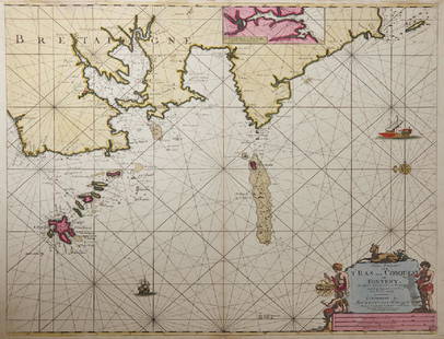
Sold2019Gerard Van Keulen (1654-1715, Amsterdam), "NieuweGerard Van Keulen (1654-1715, Amsterdam), "Nieuwe Paskaart Von T’Ras Van Conquest, on Foneny Behelsende de West Cust van Bretaignmet," hand colored, H. - 21 1/4 in., W. - 24 3/4 in.See Sold Price
Sold2020Antique Sea Chart of the Lesser AntillesAntique Sea Chart of the Lesser Antilles by Johannes Van Keule. Pas kaart Van de Caribes Tusschen I. Barbados en ts martin. Used condition. 31" x 28 1/2" tallSee Sold Price
Sold2022KEULEN, JOHANNES VAN Pas kaart van West Indien behelsende soo deszelffs vasie kusten als d' OnderKEULEN, JOHANNES VAN Pas kaart van West Indien behelsende soo deszelffs vasie kusten als d' Onder behoorende Eylanden aan de Noord Oçeaan. Amsterdam: Johannes van Keulen, [1735]. Engraved map, haSee Sold Price
Sold2023De Eylanden van Pehou' by VAN KEULEN. Penghu Islands Taiwan. VOC chart 1753 mapTitle: De Eylanden van Pehou' by VAN KEULEN. Penghu Islands Taiwan. VOC chart 1753 map Description: De Eylanden van Pehou' by Johannes van Keulen (1753). Early 18th century Dutch sea chart with old coSee Sold Price
Sold20221687 Keulen Map of North and South America's Mostly Atlantic Coastal Areas -- Pas Kaart van WestTitle: 1687 Keulen Map of North and South America's Mostly Atlantic Coastal Areas -- Pas Kaart van West Indien Behelsende soo Deszelffs Vaste Kusten als d'Onder Behoorende Eylanden aan de Noord OceaanSee Sold Price
Sold2022(NETHERLANDS.) Heyman van Dyck. Voorne Caart-boeck van alle de Dorpen, en Polders Gelegen Inden(NETHERLANDS.) Heyman van Dyck. Voorne Caart-boeck van alle de Dorpen, en Polders Gelegen Inden Lande van Oost, ende West Voorne. Elaborate double-page etched and engraved allegorical title by RomeynSee Sold Price
Sold20161666 Original Hand Colored Map of Virginiaapprox 21" X 17"...... Pas Caerte van Nieu Nederlandt en de Engelsche Virginies, van Cabo Cod tot Cabo Canrick. (Chart of New Netherland and the English Virginias from Cape Cod to Cape Canrick [i.e. HSee Sold Price
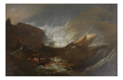
Sold2018Adriaen Van de Velde - Stormy Seas17th century oil on canvas, depicting men on ships in stormy seas. Dimensions: Art: 12" H x 18" W; Frame: 17.25" H x 23"&nbsSee Sold Price
Sold2016Willelm van de Velde the Younger (1633-1707Willelm van de Velde the Younger (1633-1707 )-attributed, Ships and boats at calm sea; oil on canvas, framed. Dimensions: 88x120cmSee Sold Price
Sold2015Willem Van De Velde Watercolor Stormy Ships at SeaWillem Van De Velde Grisaille watercolor depicting ships at sea during a storm. It is signed on back return to Mrs. Max Goldstein big collector of old masters watercolors and drawings, measures 10" xSee Sold Price
Sold2023An Oil on PanelDepicting sea scene, attributed to Hendrik van Anthonissen, (1605 - 1656), 61 x 46 cm.See Sold Price
Sold2015Insulae lavae Pars Occidentalis... (and) Insulae lavaeJohannes van Keulen (1645-1715) & Adriaan Reelant (1676-1718). 2 double page engraved maps with original hand-color in full. Amsterdam: G. van Keulen, 1728. 20 3/4 x 24 inches, 28 1/2 x 31 1/2 inchesSee Sold Price
Sold2022Jean Louis Ernest Meissonier(French, 1815-1891) Les Deux Van de Velde, the brothers Van de Velde, Willem (1633-1707) and his brother Adriaen (1636-1672), signed lower left conjoined "EMeissonier 1856", oil on panel, 10-5-8 x 8-3See Sold Price
417 Lots AwayZikorn Arts & History ObjectsPorto Rico (San Juan) 1671 Engraving by Arnoldus Montanus$400
2 days LeftTrillium Antique Prints & Rare BooksDe Jode, Rare, pub. 1593 - Map of Kingdom of Napoli, Italy (Neapolitani Regni exacta ac diligens$130(3 bids)
May 29BonhamsDALE CHIHULY (1941) Ensemble Sea Form, formé de deux pièces1995Edition Portland PressL...€1,600
2 days LeftTrillium Antique Prints & Rare BooksDe Jode, Rare, pub. 1593 - Map of Hainut, Belgium (Hannoniae Comitatus Descriptio)$100(1 bid)
May 29BonhamsLINO TAGLIAPIETRA (1934) Vase asymétriquePièce unique1987Signé et daté 'Lino...€800
May 28Carlo Bonte AuctionsPol Spilliaert (1935-2023), 'In 't midden van de tuin', polished bronze, 2010 56 x 63 x 27 cm. (22.0€3,000
May 28Carlo Bonte AuctionsPol Spilliaert (1935-2023), 'In 't midden van de tuin', patinated bronze, 2010 85 x 90 x 32 cm.€3,000
6 days LeftKinghams AuctioneersGerard van den Berg (Dutch, 1947), for Montis, a blue leather lounge chair and ottoman, on aluminium£150


![KEULEN, JOHANNES VAN Pas kaart Van de Boght van Florida Met de Canaal Tusschen Florida en Cuba Door.: KEULEN, JOHANNES VAN Pas kaart Van de Boght van Florida Met de Canaal Tusschen Florida en Cuba Door. Amsterdam: Gerard Van Keulen, [1734]. Fifth state. Engraved map, hand colored, framed; sheet measur](https://p1.liveauctioneers.com/292/250642/130213613_1_x.jpg?height=310&quality=70&version=1654271664)


![KEULEN, JOHANNES VAN Pas kaart van West Indien behelsende soo deszelffs vasie kusten als d' Onder: KEULEN, JOHANNES VAN Pas kaart van West Indien behelsende soo deszelffs vasie kusten als d' Onder behoorende Eylanden aan de Noord Oçeaan. Amsterdam: Johannes van Keulen, [1735]. Engraved map, ha](https://p1.liveauctioneers.com/292/250642/130213616_1_x.jpg?height=310&quality=70&version=1654271664)