Sold2018U.S. Coast Survey 1853 Map of Galveston Entrace, Texas"(Sketch I No. 3) Galveston Entrance Texas" Electrotype Map Published 1843-65, Washington for "Report of the Superintendent of the U.S. Coast Survey..." Published under the supervision and direction oSee Sold Price
Sold2023Highly collectible 1860 RR map of Texas, S. A. Mitchell, Jr.One of the most attractive atlas maps of Texas to appear in the mid-19th century. This authentic antique map (160 years old) was published when the Civil War was at its height. It shows the region froSee Sold Price
Sold2022Exceptional 1864 RR map of Texas, S. A. Mitchell, Jr.One of the most attractive atlas maps of Texas to appear in the mid-19th century. This nearly 160-year-old map--published during the height of the Civil War--shows the region from western New Mexico tSee Sold Price
Sold2022Asher & Adams' unique RR map of Texas, 1871County map of East Texas depicted in the unique Asher & Adams’ style, without roads to highlight the presence of railroads. Extends from Louisiana west to beyond San Antonio and features the raSee Sold Price
Sold2022Clean 1883 RR map of Texas, Geo. F. CramInteresting cerographic map of Texas from Cram’s Unrivaled Family Atlas of the World. Predates subdivision of Tom Green, Pecos, Crockett and Presidio Counties. Shows rail system throughout statSee Sold Price
Sold2022JOHN TALLIS (1817-1876) A 'GOLD RUSH' MAP, "Mexico,JOHN TALLIS (1817-1876) A 'GOLD RUSH' MAP, "Mexico, California and Texas," LONDON, EDINBURGH AND DUBLIN, CIRCA 1851, hand-colored lithograph on paper, "The Illustrations by H. Warren & Engraved by J.See Sold Price
Sold2020Williams & Rapkin 1857 Map of British IndiaSteel Engraved Map Published 1857, London for "England's Battles by Sea and Land..." by Lieut-Colonel Williams. Centre fold as published. Drawn and Engraved by J. Rapkin. Paper Size: 13.75 x 10.5 inchSee Sold Price
Sold2020Williams & Rapkin 1857 Map of Northern IndiaSteel Engraved Map Published 1857, London for "England's Battles by Sea and Land..." by Lieut-Colonel Williams. Centre fold as published. Drawn and Engraved by J. Rapkin. Paper Size: 13.75 x 10.5 inchSee Sold Price
Sold2021Rapkin, John 1857 Map of The Crimea. Ukraine RussiaSteel Engraved Map Published 1857, London for "England's Battles by Sea and Land..." by Lieut-Colonel Williams. Centre fold as issued. Drawn & Engraved by John Rapkin. Paper Size: 14 x 10.5 inch (36 xSee Sold Price
Sold2021Rapkin, John 1857 Map of The Crimea. Ukraine RussiaSteel Engraved Map Published 1857, London for "England's Battles by Sea and Land..." by Lieut-Colonel Williams. Centre fold as issued. Drawn & Engraved by John Rapkin. Paper Size: 14 x 10.5 inch (36 xSee Sold Price
Sold2021Rapkin, John 1857 HC Map of Siege of Sebastopol, CrimeaHand Colored Steel Engraved Map Published 1857, London for "England's Battles by Sea and Land..." by Lieut-Colonel Williams. Centre fold as issued. Drawn & Engraved by John Rapkin. Paper Size: 14 x 10See Sold Price
Sold2021Rapkin, John 1857 HC Map of Siege of Sebastopol, CrimeaHand Colored Steel Engraved Map Published 1857, London for "England's Battles by Sea and Land..." by Lieut-Colonel Williams. Centre fold as issued. Drawn & Engraved by John Rapkin. Paper Size: 14 x 10See Sold Price
Sold2020USA 1903 Pair of Maps - TexasLithograph Maps Published 1903 by Adam & Charles Black, Edinburgh & London for "Encyclopaedia Brittannica" Tenth Edition. Centre fold as published. Paper Size: 16 x 11.5 inch (41 x 29cm) Good ConditioSee Sold Price
Sold2023Encyclo. Brit. 1898 Lot of 38 USA State Maps. Texas, Florida etcState Maps plus Philadelphia Town Plan. Lithograph Maps Published 1898, Edinburgh & London for "Encyclopaedia Britannica" Ninth Edition. Paper Size: 11 x 8 inch (28 x 20cm) and a few larger with centrSee Sold Price
Sold2020AN ANTIQUE SURVEY MAP, "U.S. Coast Survey: PreliminaryAN ANTIQUE SURVEY MAP, "U.S. Coast Survey: Preliminary Sketch of Galveston Bay, Texas," SECOND EDITION, CIRCA 1852, lithograph on paper, map "I, No. 2," A.D. Bache, Superintendent, "Verified by I.I.See Sold Price
Sold2023SOCIETY FOR DIFFUSION OF USEFUL KNOWLEDGE, A REPUBLIC OF TEXAS MAP, "Central America II. IncludingSOCIETY FOR DIFFUSION OF USEFUL KNOWLEDGE, A REPUBLIC OF TEXAS MAP, "Central America II. Including Texas, California and the Northern States of Mexico," LONDON, CIRCA 1842, lithograph on paper, publisSee Sold Price
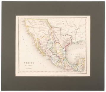
Sold2020Tallis map of Texas, California & Mexico 1851Heading: (Texas) Author: Tallis, John Title: Mexico, California and Texas Place Published: London & New York Publisher: Date Published: [1851] Description: Steel-engraved map, drSee Sold Price
Sold2017Galveston Bay & Texas Land Company Certificate withGalveston Bay & Texas Land Company, Scrip No. 1070 for One Sitio, containing 4428 102/1000 English Acres. New York. October 16, 1830. 8 x 12.5 in. Featuring a map of the company's Texas land holdings,See Sold Price
Sold2022Uncommon Texas/Indian Territory RR map, 1890Unusual map of Texas and Indian Territory by McNally showing highly detailed picture of Native American tribe locations in Indian Territory. Presents a thorough overview of railroad lines in the regioSee Sold Price
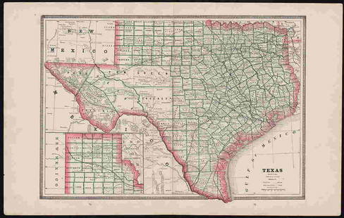
Sold2023Eight Antique Maps of TexasEight Antique Maps of Texas , incl. "Map of the United States and Texas Boundary Line...", 1857-1860 (1902); "Map of a Tour from Independence...by A. Wislizenus, in 1846 and 1847"; "N.W. Corner & Pan-See Sold Price
Sold2017Mitchell: County Map of Texas, 1862County Map of Texas, S. Augustus Mitchell, 1862. 10.75 x 13.375 inches. Steel engraved map, with hand colored wash and outlines. Inset map of Galveston Bay, and Vicinity. Colored by county and territoSee Sold Price
Sold2018A NEWSPRINT FRAGMENT FROM THE ILLUSTRATED LONDON NEWS,A NEWSPRINT FRAGMENT FROM THE ILLUSTRATED LONDON NEWS, "REVIEW OF TEXAS TROOPS, PORT OF GALVESTON AND CITY OF HOUSTON CAPITAL OF TEXAS," JANUARY 4, 1845, three engravings of important, early Texas panSee Sold Price
Sold2023Flemming - Map of Texas with Inset of Galveston BayThis historic map of Texas is by Carl Flemming and titled "Texas." The map was published c1850 by the author. The map took inspiration from John Arrowsmith's Republic of Texas Map. There is an inset oSee Sold Price
Sold2020Mexico with a large independent Texas, c.1845 mapHeading: Author: Gilbert, James Title: Mexico & Texas Place Published: London Publisher:Grattan & Gilbert Date Published: c.1845 Description: Engraved map, hand-colored in outliSee Sold Price
5 days LeftRail & Road AuctionsEleven Army Corps of Engineers Port Series No. 1 Through No. 8 Books with Fold Out Maps$35(2 bids)
4 days LeftRail & Road AuctionsTwo US Letters Patents for Railroad Weed Burners and Locomotive Circulating Exhaust Attachments$30
2 hrs LeftTremont Auctions18th century map of New Jersey. "A New and Accurate Map of New Jersey". W. Long, London. Map size 13$100
May 16Potter & Potter AuctionsSTORM, Mark. Official Texas Brags Map of North America. 194...$200(1 bid)
4 days LeftRail & Road AuctionsTwenty-One Pieces of Railroad Paper - Post Cards, Photographs, and Passenger's Check Stub$20
May 15University ArchivesFeb. 1777 Issue of The Gentleman's Magazine with Superb Map of Philadelphia$140(1 bid)
10 hrs LeftCurated Gallery AuctionsDawson Dawson-Watson (1864-1939) Antique American Impressionist Texas Seascape Original Painting$20(2 bids)
May 12Schilb Antiquarian Rare Books1844 Siege of Gibraltar American Revolution SPAIN France Drinkwater MAP History$1(1 bid)
May 15University ArchivesDeclaration of Independence, Very Early British Publ. in Gentleman's Magazine & Rare Map$1,000
May 16Zikorn Arts & History ObjectsWest Indies, Providence, Windward, Cuba 1834 British Admiralty Map$100(1 bid)
3 days LeftJasper521775-1780 Southwest (Arizona, New Mexico, Texas, with most of Mexico) by Bonne & Raynal$160(1 bid)
4 days LeftSTAIRRobert Hackett (1830-1858): Isamabard Kingdom Brunel by the Launching Chains of the Great Eastern$200


![[MAP]. GALVESTON RR. Texas. London, [1857] First Image](https://p1.liveauctioneers.com/514/38480/16487196_1_x.jpg?height=300&quality=1&version=1363614971&width=300)
![[MAP]. GALVESTON RR. Texas. London, [1857] First Image](https://p1.liveauctioneers.com/514/38480/16487196_1_x.jpg?height=300&quality=95&version=1363614971&width=300)


![Tallis map of Texas, California & Mexico 1851: Heading: (Texas) Author: Tallis, John Title: Mexico, California and Texas Place Published: London & New York Publisher: Date Published: [1851] Description: Steel-engraved map, dr](https://p1.liveauctioneers.com/642/174090/87617796_1_x.jpg?height=310&quality=70&version=1595023143)


![[SLAVERY] Texas Legal Docket re: Slave Sale (1 of 3)](https://p1.liveauctioneers.com/7226/322253/173251507_1_x.jpg?height=282&quality=70&version=1710004847)


